What it's like to live in Stirling
Stirling is a compact city in central Scotland, home to around 37,900 people, with a castle on the crag above and the Ochils and Wallace Monument filling the skyline. It suits people who want city conveniences within a short walk but countryside close by. The King's Knot gardens and the Thistles Shopping Centre sit almost side by side, which tells you a lot.
"I'd move here" adds Stirling to the areas on your listing, so homes here are matched to you first.
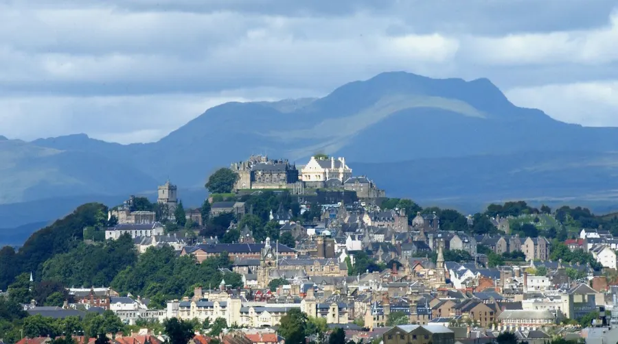
Stirling sits in the middle of Scotland's central belt, head of the Stirling council area, with Bridge of Allan just up the road and Bannockburn and Cambusbarron on its edges. Glasgow and Edinburgh are both reachable from here, which is a big part of why people look at it.
It is a city by title but a town by size, with roughly 37,900 residents in the city itself and about 94,000 across the wider council area. That mix of small-scale living and city-level services, shops, hospitals, a railway station and a bus station, is the main draw for families thinking about a move.
The other pull is setting. Stirling is where the Lowlands meet the Highlands, and the hills, the river and the castle rock are part of daily life rather than a day trip. Tenants moving here usually want somewhere they can manage without a car if they need to, but with open country a short journey away. It is a popular area, so a swap can take patience, and it helps to be clear about which part of the city would suit you.
Swapping to Stirling: key facts
Can I swap my council or housing association home to Stirling?
Yes, if you are already a council or housing association tenant. Mutual exchange means swapping homes with another social tenant, so it does not depend on the council waiting list: you need a tenant in or near Stirling who wants your area, and both landlords must agree. Landlords have 42 days to decide and can only refuse on set legal grounds.
How much social housing is there in Stirling and who owns it?
16.5% of homes in the Stirling council area are social housing (council %, housing association %), against 23.1% across England, according to the 2021 Census. The biggest social landlords there are Stirling Council (6,188 homes), Forth Housing Association Ltd (1,023 homes) and Rural Stirling Housing Association Ltd (696 homes).
How Busy Is The Swap Market In Stirling?
Figures as of 21 October 2026, updated every night.
Which homes are available to swap near Stirling?
Homes are shown near their address, not on it. Contains OS data © Crown copyright and database right. Source: Office for National Statistics, Open Government Licence.
No homes listed within 5 miles at the moment. New homes are listed every week: see homes across Scotland, use the alert form below, or list your own home so tenants here can find you.
What is housing like in Stirling and who lives there?
Social renting is less common here than nationally. In the Stirling council area, 16.5% of homes are socially rented against 23.1% across Scotland, while 67.8% are owned outright or with a mortgage and 15.5% are privately rented. In plain terms, there is less social housing to go round, so swaps can take time and flexibility helps.
Stirling Council is by far the biggest social landlord with around 6,188 homes. Forth Housing Association has about 1,023, Rural Stirling Housing Association 696, Castle Rock Edinvar 227 and Paragon 159. Between them they cover the city and the villages around it, so check who your potential swap partner's landlord is early on, as both landlords must agree.
The people living here span all ages. Across the council area, 22.8% are aged 25 to 44, 27.3% are 45 to 64 and 21.6% are 65 or over, slightly older than Scotland overall in the middle-age bracket. It feels like a settled place rather than one that turns over quickly.
Biggest social landlords in the council area
- Stirling Council6,188 homes
- Forth Housing Association Ltd1,023 homes
- Rural Stirling Housing Association Ltd696 homes
- Castle Rock Edinvar Housing Association Ltd227 homes
- Paragon Housing Association Ltd159 homes
- Link Group Ltd135 homes
- Bield Housing & Care105 homes
- Hanover (Scotland) Housing Association Ltd93 homes
What is it like to live in Stirling?
Everyday life happens in a small area. The city centre has M&S Foodhall and Waitrose almost on the doorstep, with Lidl, Aldi and Tesco all within half a mile, so a big shop or a quick top-up is easy whether you drive or not. Stirling Arcade and the Thistles cover the rest.
Green space is never far. Victoria Square, Beechwood Park, Drummond Pleasure Ground and Thistle Park are all within a mile, and the King's Knot below the castle is a fine spot for a wander. Stirling Library is a few minutes from the centre, with branches at Bannockburn and Bridge of Allan. For health, there's Stirling Health and Care Village just over half a mile away, plus BMI Kings Park Hospital and pharmacies at Cornton and Strathallan.
What are the schools and family life like in Stirling?
Families are well served for schools. Allan's Primary is about a third of a mile from the centre, with Riverside, Braehead, St Ninian's and Borestone Primary all within a mile and a half. Having several options close together is useful if you are swapping and need to think about catchment.
For older children there are four secondaries within three miles: Stirling High, St Modan's High, Bannockburn High and Wallace High. Most are walkable or a short bus ride, and with the bus station central, getting between home and school is rarely complicated.
Beyond school, there is plenty to fill weekends. Stirling Library is close in, Beechwood Park and Thistle Park give space to run about, and community centres at Mayfield, Cambusbarron and Cambuskenneth Village Hall host local activities. 1st Stirlingshire Scouts is nearby too. In the wider council area, under-16s make up 15.3% of the population, close to the Scottish figure of 15.8%, so this is a normal family mix rather than a city of students, despite the university nearby.
Primary schools
- Allan's Primary School0.3 mi
- Riverside Primary School0.7 mi
- Braehead Primary School0.8 mi
- St Ninian's Primary School0.9 mi
- Borestone Primary School1.4 mi
Secondary schools
- Stirling High School0.8 mi
- St Modan's High School1.1 mi
- Bannockburn High School1.4 mi
- Wallace High School1.8 mi
Parks
- Victoria Square0.5 mi
- King's Knot0.7 mi
- Beechwood Park0.7 mi
- Drummond Pleasure Ground0.7 mi
- Thistle Park1 mi
Libraries
- Stirling Library0.3 mi
- Bannockburn Library2 mi
- Bridge of Allan Library2.7 mi
What shops and everyday essentials are in Stirling?
Supermarkets
- M&S Foodhallnearby
- Waitrosenearby
- Lidlnearby
- Aldi0.3 mi
- Tesco0.6 mi
Pharmacies
- St Minivans Pharmacy1.1 mi
- Cornton Pharmacy1.5 mi
- rightmedicine Pharmacy1.9 mi
- Strathallan Pharmacy2.7 mi
Hospitals
- Stirling Health and Care Village0.6 mi
- BMI Kings Park Hospital1 mi
Shopping centres
- The Thistles Shopping Centrenearby
- Stirling Arcade0.3 mi
How do you get around Stirling?
Stirling is one of the easier Scottish places to manage without a car. Stirling railway station is about a third of a mile from the centre, and Bridge of Allan station is roughly three miles out, giving you a second option. The city's position in central Scotland means rail is the practical way to reach bigger cities for work or visits.
Stirling Bus Station is a two-minute walk from the shopping centre, so local and longer-distance bus services start right where the shops and services are. That matters if you don't drive or if there are teenagers in the house who need to get about on their own.
Walking is genuinely realistic here. Supermarkets, the library, the shopping centres, the cinema and several primary schools are all inside a mile of the centre, and the city is small enough to cross on foot. Drivers get good road links through the central belt, though the centre itself is tight and parking is the usual city compromise. Think about where in Stirling a home sits before you commit, as the hillier streets make some walks harder work than the map suggests.
Train stations
- Stirling0.3 mi
- Bridge of Allan3 mi
Bus stations
- Stirling Bus Stationnearby
What is there to do in Stirling?
For a small city, Stirling packs a lot in. Vue cinema is a couple of minutes from the centre, and the McRobert, around two miles out, gives a second screen and a different programme. The Thistles Shopping Centre and the older Stirling Arcade cover shopping without needing to travel.
Outdoors, the King's Knot sits below the castle and is the most striking green space here, with Victoria Square, Drummond Pleasure Ground, Beechwood Park and Thistle Park all within a mile or so. They are everyday parks rather than big country estates, but the real countryside starts just beyond the city edge.
Evenings are easy to fill. Slanj-A-Va, The City Walls, Number 2 Baker Street, Fubar and Dusk are all within a short walk of the centre, so there's a mix of quiet pints and later nights. If keeping fit is your thing, PureGym, Limitless Fitness and The Yoga Tree Stirling are all central. Bannockburn and Bridge of Allan libraries add a little more for those living out that way.
Gyms
- PureGymnearby
- The Yoga Tree Stirlingnearby
- Limitless Fitnessnearby
Cinemas
- Vuenearby
- McRobert2.2 mi
Pubs and bars
- Slanj-A-Vanearby
- The City Wallsnearby
- Fubar0.3 mi
- Dusk0.3 mi
- Number 2 Baker Street0.3 mi
Community centres
- 1st Stirlingshire Scouts0.6 mi
- Cambuskenneth Village Hall0.8 mi
- Mayfield Community Centre1 mi
- Cambusbarron Library1.3 mi
- Cambusbarron Community Centre1.3 mi
What is work and the local economy like in Stirling?
Across the Stirling council area, 73.9% of 16 to 64 year olds are in work, just under the Scottish rate of 74.6%. That is a fairly steady picture rather than a boom area, and it suggests a decent spread of local jobs.
The better sign is benefit claims. In September 2026, 2.3% of working-age people in the council area were claiming unemployment-related benefits, compared with 3.2% across Scotland. Fewer people out of work here than the national average, which points to a reasonably resilient local labour market.
Stirling's position is its strongest work asset. With a central railway station and a bus station in the middle of the city, commuting to jobs elsewhere in central Scotland is a realistic option, not just a theory. That widens your choices if the right local role doesn't come up straight away. The age profile tells a story too: 27.3% of the council area is aged 45 to 64 and 13.1% is 16 to 24, a mix of settled workers and younger people starting out.
Figures are for the Stirling council area, Annual Population Survey (Jul 2025-Jun 2026) and claimant count.
Is Stirling a good place for social housing tenants?
If Stirling looks like the right fit, the way forward is simple. Put your own home on Mutual Home Exchange, with honest photos and a clear description of the rooms, garden or balcony, parking and anything a swapper would want to know. A well-written advert gets far more interest than a thin one.
Then set Stirling as a desired area. That way you show up to tenants here who are looking to move out, and you get a nudge when something suitable appears. It is worth adding nearby places too, such as Bridge of Allan, Bannockburn or Cambusbarron, since they share the same schools, buses and shops but may come up more often.
Be patient and be specific. Say whether you need a ground floor, how many bedrooms you can offer, and whether school catchment matters to you. Social housing is a smaller share of homes here than the Scottish average, so the right match may not appear in week one. Keep your listing updated, reply quickly to messages, and remember both landlords must approve before any move goes ahead.
Tell me when a home appears near Stirling
One email, the first time a council or housing association home is listed within your chosen distance. No newsletter, no spam.
Live in Stirling? Add a photo
Tenants' own photos help other people picture the place. Approved photos are credited to you. Submit a photo.
Nearby place guides
Thinking of moving a little further? Compare homes to swap, rents and local landlords in places near Stirling.