What it's like to live in Maltby
Maltby is a former mining town of around 16,470 people on the eastern edge of Rotherham, in South Yorkshire. It is a down-to-earth, settled sort of place where most things sit close together and people tend to stay put. It suits families and anyone who wants a proper town centre on the doorstep, with Coronation Park and open countryside close by.
"I'd move here" adds Maltby to the areas on your listing, so homes here are matched to you first.
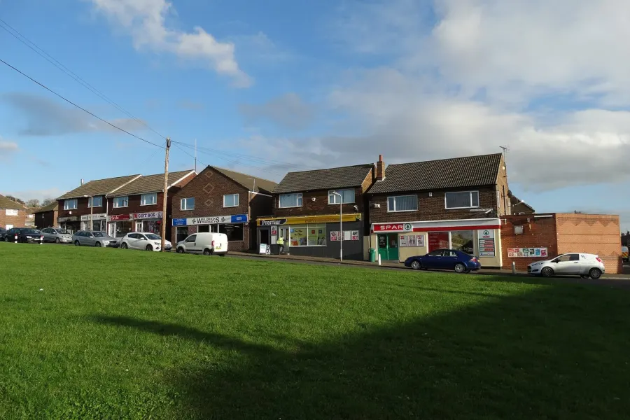
Maltby lies in the Rotherham borough of South Yorkshire, in the Yorkshire and the Humber region, with the postcode district S66. Rotherham itself is the nearest big town to the west, and Sheffield and Doncaster are the larger cities within reach of the area.
People move here for the combination of a self-contained town and lower housing costs than you find in the bigger cities. It is a place with its own schools, its own shops and its own centre, rather than a commuter estate tacked onto somewhere else. Wickersley and Bramley sit between Maltby and Rotherham, so you are not isolated.
The other draw is space. Maltby sits on the edge of the built-up part of the borough, with Sandbeck Park a couple of miles out and countryside beyond. If you are swapping from a dense inner-city estate, the change of pace is the thing most people notice first. It is a practical, unflashy choice, and that is exactly why many tenants are happy here.
Swapping to Maltby: key facts
Can I swap my council or housing association home to Maltby?
Yes, if you are already a council or housing association tenant. Mutual exchange means swapping homes with another social tenant, so it does not depend on the council waiting list: you need a tenant in or near Maltby who wants your area, and both landlords must agree. Landlords have 42 days to decide and can only refuse on set legal grounds. In 2024 to 2025, 57 council homes in Rotherham changed tenants by mutual exchange.
How long is the council housing waiting list in Maltby?
7,033 households were on the Rotherham housing register on 31 March 2025, down 2% on a year earlier. 1,539 social homes were let through the council in 2024 to 2025, roughly 4.6 households for every home let. Source: Local Authority Housing Statistics, Ministry of Housing, Communities and Local Government.
How much is social rent in Maltby?
Average weekly social rents in the Rotherham council area in 2024/25: 1 bed £83 council, £86 housing association; 2 bed £91 council, £101 housing association; 3 bed £98 council, £112 housing association. Affordable rent homes cost more, typically 60 to 80% of market rent. Source: Regulator of Social Housing.
How much social housing is there in Maltby and who owns it?
20.7% of homes in the Rotherham council area are social housing (council 16.7%, housing association 4%), against 17.1% across England, according to the 2021 Census. The biggest social landlords there are Rotherham Metropolitan Borough Council (20,076 homes), South Yorkshire Housing Association Limited (1,176 homes) and The Guinness Partnership Limited (760 homes).
How Busy Is The Swap Market In Maltby?
Figures as of 23 October 2026, updated every night. The waiting list figure is from 2024 to 2025 government data.
Which homes are available to swap near Maltby?
Homes are shown near their address, not on it. Contains OS data © Crown copyright and database right. Source: Office for National Statistics, Open Government Licence.
No homes listed within 5 miles at the moment. New homes are listed every week: see homes across South Yorkshire, use the alert form below, or list your own home so tenants here can find you.
What is housing like in Maltby and who lives there?
Across the Rotherham council area, 20.7% of homes are social rented, above the England figure of 17.1%. Most of that is council stock at 16.7%, with housing associations making up 4%. Owner occupation is high at 63.6% and private renting relatively low at 15%, which gives neighbourhoods a stable, long-settled feel.
Rotherham Metropolitan Borough Council is by far the biggest landlord with around 20,076 homes. South Yorkshire Housing Association has about 1,176, The Guinness Partnership 760, Sanctuary Housing Association 730 and Together Housing Association 568. Average weekly social rents in the borough in 2024/25 were £84 for a one bed, £93 for two beds and £100 for three.
The age profile is close to the national picture, with 26.8% aged 45 to 64 and 19.6% aged 65 and over, both a shade above England. Demand for social housing is real: 7,033 households were on the council's register at March 2025, and 1,539 homes were let in 2024-25. A register is not a simple queue, which is one reason mutual exchange is worth considering.
Council waiting list and lettings
Households on the register by the size of home they need.
That is roughly 4.6 households waiting for every social home let in a year. Mutual exchange doesn't use the waiting list: if you already have a council or housing association home, swapping with another tenant can be a quicker way to move to Maltby.
A register counts households who have applied, so it isn't a simple queue: some are already social tenants hoping to transfer, and people can be on more than one council's list.
Typical weekly social rents in the Rotherham council area
| Size | Council | Housing association |
|---|---|---|
| Bedsit | £63 | £72 |
| 1 bed | £83 | £86 |
| 2 bed | £91 | £101 |
| 3 bed | £98 | £112 |
| 4 bed | £110 | £126 |
Social rent averages for 2024/25. Affordable rent homes cost more, typically 60 to 80% of market rent.
Biggest social landlords in the council area
- Rotherham Metropolitan Borough Council20,076 homes
- South Yorkshire Housing Association Limited1,176 homes
- The Guinness Partnership Limited760 homes
- Sanctuary Housing Association730 homes
- Together Housing Association Limited568 homes
- Great Places Housing Association503 homes
- Arches Housing Limited382 homes
- Places for People Homes Limited207 homes
What is it like to live in Maltby?
Day-to-day life is easy here because the basics are all within a short walk of the middle of town. There is a Tesco right in the centre, Heron Foods a minute away and an Aldi just up the road, with Weldricks Pharmacy nearby. A Morrisons sits a little over two miles out for a bigger shop.
The streets are a mix of older terraces and estate housing, much of it built around the pit years, with plenty of social housing among it. Community life matters: the Wesley Centre, St Bartholemews Church Rooms, Edward Dunn Memorial Hall and the Bevan Crescent Neighbourhood Centre all sit within half a mile, and the Maltby Customer Service Centre is handy for council business.
What are the schools and family life like in Maltby?
Families are well served for schools. Maltby Manor Academy is about a third of a mile away, with Maltby Crags Junior & Infant Schools, St Mary's Catholic Primary School and Maltby Lilly Hall Academy all within about half a mile. That is five primaries inside a ten-minute walk of the middle of town, which gives real choice.
For older children, Maltby Academy is right in the town, under half a mile out. Hilltop School, a specialist setting, is under a mile away, Abbeywood School is around 1.8 miles and Wickersley School and Sports College is just under three miles, so there are options beyond the nearest school if you need them.
Outside the school gates, Coronation Park is the main local green space for younger children, a short walk from the centre. The community centres dotted around town are the places to look for groups and activities. Across the Rotherham council area, 18.8% of residents are under 16, slightly above the England figure, so this is an area used to children.
Primary schools
- Maltby Manor Academy0.3 mi
- Maltby Crags Junior & Infant Schools0.5 mi
- St Mary's Catholic Primary School (Maltby)0.5 mi
- Saint Mary's Catholic Primary School0.5 mi
- Maltby Lilly Hall Academy0.6 mi
Secondary schools
- Maltby Academy0.3 mi
- Hilltop School0.9 mi
- Abbeywood School1.8 mi
- Wickersley School and Sports College2.9 mi
Parks
- Coronation Park0.3 mi
- view park0.9 mi
- Sandbeck Park2.2 mi
- Bramley Park2.7 mi
What shops and everyday essentials are in Maltby?
Supermarkets
- Tesconearby
- Heron Foodsnearby
- Aldi0.4 mi
- Morrisons2.3 mi
- The Co-operative Food2.9 mi
Pharmacies
- Weldricks Pharmacynearby
How do you get around Maltby?
The honest answer is that Maltby is a walking town first. The shops, the pharmacy, the community centres, Coronation Park, the primary schools and Maltby Academy are all within roughly half a mile of the centre, so a lot of daily life can be done on foot without needing a car or a bus fare.
For anything further, you will want wheels or public transport. Rotherham, Wickersley and the wider borough lie to the west, and Maltby sits near the main east-west routes across this part of South Yorkshire, which is what makes driving to work in Rotherham, Sheffield or Doncaster realistic for many households.
We do not have detailed bus or rail information for Maltby to pass on, and there is no station in the town itself, so if you rely on public transport it is worth checking current timetables and journey times for your own route before you commit to a swap. Ask whoever you are swapping with: local tenants usually know which services are reliable.
What is there to do in Maltby?
Green space is the easy win. Coronation Park sits about a third of a mile from the centre, with a smaller view park under a mile away. Sandbeck Park is a little over two miles out and Bramley Park around 2.7 miles, so a change of scenery is a short drive or a decent walk.
Maltby has kept a proper pub scene for a town its size. The Don John and Drinks & Ink are a minute from the centre, with The Queens Hotel just along from them and The Sheppey and Manor Hotel about half a mile out. They are local pubs rather than destination bars, which is rather the point.
For organised exercise, Bannatyne's Health Club is the nearest gym at around 2.2 miles. Community life leans on halls and centres such as the Wesley Centre and Edward Dunn Memorial Hall, which tend to host the groups, clubs and events that keep a town like this ticking over.
Gyms
- Bannatyne's Health Club2.2 mi
Pubs and bars
- Don Johnnearby
- Drinks & Inknearby
- The Queens Hotelnearby
- The Sheppey0.5 mi
- Manor Hotel0.5 mi
Community centres
- Maltby Customer Service Centrenearby
- The Wesley Centrenearby
- St Bartholemews Church Roomsnearby
- Edward Dunn Memorial Hall0.3 mi
- Bevan Crescent Neighbourhood Centre.0.4 mi
What is work and the local economy like in Maltby?
Figures here cover the wider Rotherham council area rather than Maltby alone. Among adults, 54.6% are in work, a little below the England average of 57.4%, and unemployment stands at 3.2%, slightly under the 3.5% recorded for England.
More recent benefit figures put unemployment-related claimants at 3.7% of 16 to 64 year olds across the borough, against 4% nationally. So the local labour market is not booming, but it is not an outlier either. Rotherham has a long industrial history and the job market still reflects that mix of manufacturing, logistics, retail, care and public services.
In practice, many Maltby households travel out for work. Rotherham town centre, Wickersley and the bigger employment areas towards Sheffield and Doncaster are the usual directions. If you are moving for a specific job, check the commute carefully, especially if you will be doing it without a car or on shift patterns.
Figures are for the Rotherham council area, Census 2021 and ONS claimant count.
How safe is Maltby?
Like every town centre, Maltby has police incidents logged each month. In August 2026 there were 144 within about a mile of the centre, made up of:
- Anti-social behaviour reports21
- Vehicle crime10
- Shoplifting13
- Other theft2
- Theft from the person1
- Criminal damage12
Source: data.police.uk street-level crime. Counts cover a fixed one-mile radius around the centre, so busy high streets and stations always record far more than the residential streets around them, and most incidents are minor. Compare like with like: a similar-sized town centre, not a village.
Is Maltby a good place for social housing tenants?
If Maltby looks like the right fit, the next step is simple. Put your own home on Mutual Home Exchange with clear photos and an honest description, then add Maltby, or the S66 postcode district, to your list of desired areas. Swaps happen when the right match comes along, and you cannot be matched if you are not listed.
It is worth being specific about what you need and what you can offer: number of bedrooms, floor level, garden, parking, adaptations. Tenants looking at your advert will want the same straight answers you want from them. Mention the things you like about your current home as well as the reasons you are moving.
Mutual exchange is a well-used route in this borough: 57 council homes were swapped this way in 2024-25. Keep an eye on new listings, message people whose homes suit you rather than waiting to be approached, and remember your landlord will need to approve any exchange before it goes ahead. Patience and a good advert go a long way.
Tell me when a home appears near Maltby
One email, the first time a council or housing association home is listed within your chosen distance. No newsletter, no spam.
Live in Maltby? Add a photo
Tenants' own photos help other people picture the place. Approved photos are credited to you. Submit a photo.
Nearby place guides
Thinking of moving a little further? Compare homes to swap, rents and local landlords in places near Maltby.
All place guides in South Yorkshire → · All place guides in Yorkshire & Humber → · All regions →