What it's like to live in Dorking
Dorking is a small Surrey market town of around 11,000 people, tucked under the Surrey Hills in the Mole Valley district. It feels like a proper town rather than a commuter dormitory: a working high street, independent shops and pubs, and countryside starting almost at the back of the houses. It suits families and anyone who wants green space and a station close by.
"I'd move here" adds Dorking to the areas on your listing, so homes here are matched to you first.
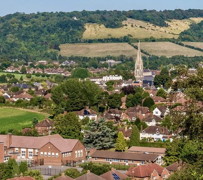
Dorking sits in the Mole Valley district of Surrey, in the gap where the River Mole cuts through the North Downs. Leatherhead and Reigate are the nearest sizeable towns, Guildford and Crawley are within reach, and London lies to the north. The wider council area has a population of about 87,000, but Dorking itself is a town of roughly 11,000.
People move here for the setting. The Surrey Hills wrap around the town on almost every side, with Box Hill just up the road, and yet three railway stations serve the town itself. That mix of countryside and connections is rare, and it is the main reason Dorking holds its appeal for families and older movers alike.
For a social tenant, the trade-off is supply. Mole Valley has a smaller social housing sector than England as a whole, so a mutual exchange is often the most realistic route in. If you want a quieter, greener base that still has a town centre and trains, Dorking is worth setting as a desired area and waiting for the right match.
Swapping to Dorking: key facts
Can I swap my council or housing association home to Dorking?
Yes, if you are already a council or housing association tenant. Mutual exchange means swapping homes with another social tenant, so it does not depend on the council waiting list: you need a tenant in or near Dorking who wants your area, and both landlords must agree. Landlords have 42 days to decide and can only refuse on set legal grounds.
How long is the council housing waiting list in Dorking?
653 households were on the Mole Valley housing register on 31 March 2025, down 4% on a year earlier. 205 social homes were let through the council in 2024 to 2025, roughly 3.2 households for every home let. Source: Local Authority Housing Statistics, Ministry of Housing, Communities and Local Government.
How much is social rent in Dorking?
Average weekly social rents in the Mole Valley council area in 2024/25: 1 bed £0 council, £119 housing association; 2 bed £0 council, £141 housing association; 3 bed £0 council, £157 housing association. Affordable rent homes cost more, typically 60 to 80% of market rent. Source: Regulator of Social Housing.
How much social housing is there in Dorking and who owns it?
11.7% of homes in the Mole Valley council area are social housing (council 1.5%, housing association 10.1%), against 17.1% across England, according to the 2021 Census. The biggest social landlords there are Clarion Housing Association Limited (3,619 homes), Mount Green Housing Association Limited (450 homes) and Southern Housing (104 homes).
How Busy Is The Swap Market In Dorking?
Figures as of 21 October 2026, updated every night. The waiting list figure is from 2024 to 2025 government data.
Which homes are available to swap near Dorking?
Homes are shown near their address, not on it. Contains OS data © Crown copyright and database right. Source: Office for National Statistics, Open Government Licence.
No homes listed within 5 miles at the moment. New homes are listed every week: see homes across Surrey, use the alert form below, or list your own home so tenants here can find you.
What is housing like in Dorking and who lives there?
Mole Valley is dominated by owner-occupiers. Across the council area 73.2% of homes are owned outright or with a mortgage, 14.1% are privately rented and just 11.7% are social rented, below the England figure of 17.1%. Only 1.5% is council housing, with 10.1% held by housing associations, so most social tenants here have an association as their landlord.
Clarion Housing Association is much the biggest, with around 3,619 homes in the area, followed by Mount Green Housing Association with 450, Southern Housing with 104, Metropolitan Housing Trust with 70 and The Grange Centre for People with Disabilities with 62. Average weekly social rents in 2024/25 were about £119 for a one bed, £141 for two beds and £157 for three.
The area skews older than England: 23.8% of residents are 65 or over against 18.4% nationally, while 25 to 44 year olds are under-represented. At 31 March 2025 there were 653 households on the council's housing register and 205 social homes were let in the year, which gives a sense of how tightly held homes are here.
Council waiting list and lettings
Households on the register by the size of home they need.
That is roughly 3.2 households waiting for every social home let in a year. Mutual exchange doesn't use the waiting list: if you already have a council or housing association home, swapping with another tenant can be a quicker way to move to Dorking.
A register counts households who have applied, so it isn't a simple queue: some are already social tenants hoping to transfer, and people can be on more than one council's list.
Typical weekly social rents in the Mole Valley council area
| Size | Council | Housing association |
|---|---|---|
| Bedsit | £0 | £121 |
| 1 bed | £0 | £119 |
| 2 bed | £0 | £141 |
| 3 bed | £0 | £157 |
| 4 bed | £0 | £177 |
Social rent averages for 2024/25. Affordable rent homes cost more, typically 60 to 80% of market rent.
Biggest social landlords in the council area
- Clarion Housing Association Limited3,619 homes
- Mount Green Housing Association Limited450 homes
- Southern Housing104 homes
- Metropolitan Housing Trust Limited70 homes
- The Grange Centre for People with Disabilities62 homes
- A2Dominion South Limited62 homes
- Transform Housing & Support61 homes
- Raven Housing Trust Limited41 homes
What is it like to live in Dorking?
Day to day, most things sit within a short walk of the centre. There is a Sainsbury's and a Waitrose a few minutes from the high street and a Lidl a little further out, plus a cluster of pharmacies including Boots, Superdrug, South Street Pharmacy and Medwyn Pharmacy. Dorking Library is right in the middle of town.
Green space is the town's strong suit. Cotmandene and Meadowbank Park are both a couple of minutes from the centre, with Dorking Rec and Fraser Gardens nearby too. Dorking Community Hospital is around half a mile out. Community life runs through places like the Malthouse, Oddfellow's Hall and Crossways Community Centre. Be honest with yourself about cost: this is an expensive part of Surrey, and shops and eating out reflect that.
What are the schools and family life like in Dorking?
Dorking is a good fit for families who want schools close to home. Within half a mile of the centre you have St Joseph's Catholic Primary, St Paul's CofE Primary and St Martin's CofE Primary, with Powell Corderoy Primary a little under a mile away and Starhurst School nearby.
For older children, The Ashcombe School is about 0.4 miles from the centre and The Priory Church of England School roughly 0.7 miles, so plenty of teenagers walk or cycle. RGS Surrey Hills is around 2.5 miles out. Always check current admission rules and catchments with Surrey County Council before you commit to a swap, as places change year to year.
Outside school, there is plenty to fill a weekend. Meadowbank Park and the Dorking Rec give space for football and running about, Cotmandene is a short walk from the centre, and Dorking Library is handy for younger readers. Community centres including Crossways and the Malthouse host local groups. Dorking Community Hospital is close by for routine appointments.
Primary schools
- St Joseph's Catholic Primary School0.4 mi
- St Paul's CofE Primary School0.4 mi
- St Martin's CofE Primary School0.5 mi
- Powell Corderoy Primary School0.8 mi
- Starhurst School0.9 mi
Secondary schools
- The Ashcombe School0.4 mi
- The Priory Church of England School0.7 mi
- RGS Surrey Hills2.5 mi
Parks
- Cotmandenenearby
- Meadowbank Parknearby
- Dorking Rec - Meadowbank Recreation Ground0.3 mi
- Fraser Gardens0.4 mi
- Donkey Green1.4 mi
Libraries
- Dorking Librarynearby
- County Library Sub-Headquarters0.4 mi
What shops and everyday essentials are in Dorking?
Supermarkets
- Sainsbury'snearby
- Waitrosenearby
- Lidl0.4 mi
Pharmacies
- Superdrugnearby
- Bootsnearby
- Michael Frith Pharmacynearby
- South Street Pharmacy0.3 mi
- Medwyn Pharmacy0.3 mi
Hospitals
- Priory Pelham Woods0.5 mi
- Dorking Community Hospital0.5 mi
How do you get around Dorking?
Dorking is unusually well served by rail for a town its size. Dorking station is about 0.6 miles from the centre, with Dorking Deepdene and Dorking West both around half a mile out. Box Hill & Westhumble is 1.5 miles away and Betchworth under three miles. Between them they give you options in several directions, which helps if you commute or travel for appointments.
On foot, the town centre works well. The library, supermarkets, pharmacies and several parks are all within half a mile of the middle, and the schools are close too. The hills mean some streets are steep, so think about that if walking is harder for you.
By car, Dorking sits on main routes through the Mole gap towards Leatherhead and the M25 to the north, and Reigate and Horsham beyond. Local buses link the town with surrounding villages and nearby towns. Parking in the centre is limited at busy times, and the roads through the gap can be slow in the rush hour, so allow extra time.
Train stations
- Dorking West0.5 mi
- Dorking Deepdene0.5 mi
- Dorking0.6 mi
- Box Hill & Westhumble1.5 mi
- Betchworth2.9 mi
What is there to do in Dorking?
The countryside is the headline. The Surrey Hills reach right up to the town, and closer in you have Cotmandene, Meadowbank Park, Fraser Gardens, the Dorking Rec and Donkey Green about 1.4 miles out. For many people here, a walk is the default weekend plan, and it costs nothing.
In town, the pub scene is strong for a place this size. The White Horse, The White Hart, the Surrey Yeoman, Red Bar & Lounge and the Deepdene are all in or near the centre. There are independent shops along the high street alongside the bigger names, which gives the town more character than most Surrey commuter stops.
If you like to train, Studio 224 and Anytime Fitness are both within a quarter of a mile of the centre. Dorking Library is a free, warm place to spend time, and the Malthouse, Oddfellow's Hall and the Christian Community Centre host local groups and events. It is a town where community activity matters more than big attractions.
Gyms
- Studio 224nearby
- Anytime Fitnessnearby
Pubs and bars
- The White Horsenearby
- Surrey Yeomannearby
- The White Hartnearby
- Red Bar & Loungenearby
- Deepdenenearby
Community centres
- Oddfellow's Hallnearby
- The Malthousenearby
- Christian Community Centrenearby
- Resource Centrenearby
- Crossways Community Centre0.3 mi
What is work and the local economy like in Dorking?
Across the Mole Valley council area, 58.5% of adults are in work, a shade above the England figure of 57.4%. Unemployment is low at 2.3% against 3.5% for England, and unemployment-related benefit claims stood at 1.9% of working-age people in September 2026, compared with 4% nationally. In short, this is an area where work is relatively easy to come by, though wages and costs both sit at Surrey levels.
Plenty of residents commute. With three stations in the town, Dorking works for people travelling to Guildford, Reigate, Redhill, Horsham or London, and the road links north towards the M25 open up more options.
Locally, jobs tend to sit in town centre retail and hospitality, health and care, including Dorking Community Hospital, schools, and services across the surrounding villages. If you drive, your realistic job market stretches well beyond the town itself.
Figures are for the Mole Valley council area, Census 2021 and ONS claimant count.
How safe is Dorking?
Like every town centre, Dorking has police incidents logged each month. In August 2026 there were 80 within about a mile of the centre, made up of:
- Anti-social behaviour reports24
- Vehicle crime1
- Shoplifting11
- Other theft5
- Criminal damage4
- Burglary3
Source: data.police.uk street-level crime. Counts cover a fixed one-mile radius around the centre, so busy high streets and stations always record far more than the residential streets around them, and most incidents are minor. Compare like with like: a similar-sized town centre, not a village.
Is Dorking a good place for social housing tenants?
If Dorking appeals, the practical step is to get your own home listed and add Dorking as a desired area. Mutual exchange works on matches, and matches only happen when both sides can see each other, so a clear, honest listing does more for you than waiting quietly.
Take decent photos in daylight, be straight about the number of bedrooms, the floor you are on, heating, parking and any steps or stairs. Say what is good about your area too, because someone out there is looking for exactly what you have. Then set your preferences and check back regularly rather than once a month.
When an offer comes in, visit if you can, and ask about running costs, the state of the building and anything the photos do not show. Both landlords must approve the swap before anything is agreed, so start those conversations early. Dorking homes do not come up often, so patience helps, but with your listing live and your preferences set you are in the best position to catch one when it does.
Tell me when a home appears near Dorking
One email, the first time a council or housing association home is listed within your chosen distance. No newsletter, no spam.
Live in Dorking? Add a photo
Tenants' own photos help other people picture the place. Approved photos are credited to you. Submit a photo.
Nearby place guides
Thinking of moving a little further? Compare homes to swap, rents and local landlords in places near Dorking.
All place guides in Surrey → · All place guides in the South East → · All regions →