What it's like to live in Marple
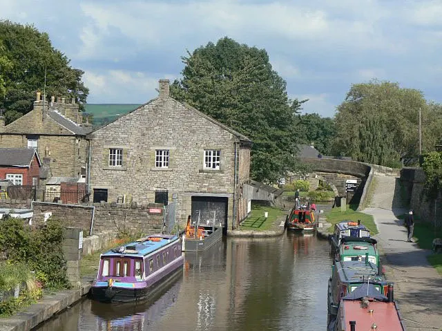
Marple is a green, canal-side town of around 12,970 people on the eastern edge of Stockport, where Greater Manchester starts to turn into Peak District countryside. It suits families and anyone who wants a proper town centre with hills and water on the doorstep. Etherow Country Park and Brabyns Park are both close, and the little Regent cinema is a local favourite.
"I'd move here" adds Marple to the areas on your listing, so homes here are matched to you first.
Marple sits in the south-east corner of the Stockport borough, in Greater Manchester's North West. Stockport town centre is the nearest big centre, with Romiley, Bredbury and High Lane all just a short hop away, and the Cheshire and Derbyshire countryside beginning more or less where the houses end.
People move here for the combination: a small town with its own identity and train stations, but with bigger places within easy reach. The SK6 postcode covers Marple and its neighbours, and the town is big enough to feel self-contained at around 12,970 residents without being a sprawl.
For tenants considering a swap, the draw is usually space and setting. Marple is a long way in feel from inner-city Manchester, yet still firmly inside a large borough of nearly 295,000 people with the services that brings. It tends to appeal to households looking for somewhere settled, with countryside walks, canals and a steady, familiar high street rather than constant change.
Swapping to Marple: key facts
Can I swap my council or housing association home to Marple?
Yes, if you are already a council or housing association tenant. Mutual exchange means swapping homes with another social tenant, so it does not depend on the council waiting list: you need a tenant in or near Marple who wants your area, and both landlords must agree. Landlords have 42 days to decide and can only refuse on set legal grounds. In 2024 to 2025, 191 council homes in Stockport changed tenants by mutual exchange.
How long is the council housing waiting list in Marple?
8,208 households were on the Stockport housing register on 31 March 2025, up 29% on a year earlier. 921 social homes were let through the council in 2024 to 2025, roughly 8.9 households for every home let. Source: Local Authority Housing Statistics, Ministry of Housing, Communities and Local Government.
How much is social rent in Marple?
Average weekly social rents in the Stockport council area in 2024/25: 1 bed £81 council, £95 housing association; 2 bed £92 council, £105 housing association; 3 bed £103 council, £115 housing association. Affordable rent homes cost more, typically 60 to 80% of market rent. Source: Regulator of Social Housing.
How much social housing is there in Marple and who owns it?
13.3% of homes in the Stockport council area are social housing (council 7.8%, housing association 5.5%), against 17.1% across England, according to the 2021 Census. The biggest social landlords there are Stockport Metropolitan Borough Council (10,953 homes), Great Places Housing Association (1,670 homes) and The Guinness Partnership Limited (1,206 homes).
How Busy Is The Swap Market In Marple?
Figures as of 24 October 2026, updated every night. The waiting list figure is from 2024 to 2025 government data.
Which homes are available to swap near Marple?
Homes are shown near their address, not on it. Contains OS data © Crown copyright and database right. Source: Office for National Statistics, Open Government Licence.
No homes listed within 5 miles at the moment. New homes are listed every week: see homes across Greater Manchester, use the alert form below, or list your own home so tenants here can find you.
What is housing like in Marple and who lives there?
Stockport is mostly an owner-occupier borough. Around 71.1% of homes are owned, 14.4% are privately rented and 13.3% are social rented, which is below the England average of 17.1%. Social housing splits roughly 7.8% council and 5.5% housing association, so socially rented homes are in demand.
Average weekly social rents in the borough for 2024/25 were about £85 for a one bed, £97 for two beds and £106 for three beds. Stockport Metropolitan Borough Council is by far the biggest social landlord with 10,953 homes, followed by Great Places with 1,670, The Guinness Partnership with 1,206, Mosscare St. Vincent's with 1,163 and Your Housing with 1,007.
The borough's age profile is close to the national picture, though with slightly more people aged 65 and over at 20.1%. At 31 March 2025 there were 8,208 households on Stockport's housing register, and a register is not a simple queue. In 2024-25, 921 social homes were let through the council and 191 council homes changed hands through mutual exchange.
Who owns the homes
Share of homes in the Stockport council area, Census 2021.
Ages
Share of people in each age group, Census 2021.
Council waiting list and lettings
Households on the register by the size of home they need.
That is roughly 8.9 households waiting for every social home let in a year. Mutual exchange doesn't use the waiting list: if you already have a council or housing association home, swapping with another tenant can be a quicker way to move to Marple.
A register counts households who have applied, so it isn't a simple queue: some are already social tenants hoping to transfer, and people can be on more than one council's list.
Typical weekly social rents in the Stockport council area
Social rent averages for 2024/25. Affordable rent homes cost more, typically 60 to 80% of market rent.
Biggest social landlords in the council area
- Stockport Metropolitan Borough Council10,953 homes
- Great Places Housing Association1,670 homes
- The Guinness Partnership Limited1,206 homes
- Mosscare St. Vincent's Housing Group Limited1,163 homes
- Your Housing Limited1,007 homes
- Onward Homes Limited847 homes
- Sanctuary Housing Association793 homes
- Stockport Homes Limited546 homes
What is it like to live in Marple?
Day to day, life centres on the main street and Memorial Park, which sits right in the middle of town, barely a few minutes from the shops. There is an Asda on the doorstep, a Co-op and Aldi within a couple of miles, plus Superdrug and Well Pharmacy for prescriptions and everyday bits.
The streets rise and fall, so expect a few slopes, but that is part of the appeal: canal towpaths, playing fields at Hawk Green and Brabyns Park, and Romiley Park a little further out. Marple Cottage Surgery is close by for GP appointments. Clubs matter here too, with the Social and Forces Club, the Con Club and Brabyns Recreation Centre all within walking distance of the centre.
What are the schools and family life like in Marple?
Families are well covered for schools. Rose Hill Primary School is 0.4 miles away, with All Saints Church of England Primary at 0.5 miles, and St Mary's Catholic Voluntary Academy and Ludworth Primary both around 0.6 miles. Brabyns Preparatory School is a private option on the doorstep at 0.3 miles.
For older children, Marple Hall School is just over a mile from the centre. Harrytown Catholic High School, Werneth School and Castle Hill High School are all within about 2.3 miles, and Acorns School, a specialist setting, is 0.4 miles away. There is also a sixth form college in the town. Always check catchment and admissions directly, as places change year to year.
For days out, Marple Memorial Park is a hundred yards or so from the centre, with Brabyns Park, Hawk Green and Etherow Country Park nearby for bigger runarounds. Scouts and community groups meet locally, and Stepping Hill Hospital is three miles away. Nearly 19% of the Stockport borough is under 16, in line with England.
Primary schools
- Brabyns Preparatory School0.3 mi
- Rose Hill Primary School0.4 mi
- All Saints Church of England Primary School0.5 mi
- St Mary's Catholic Voluntary Academy0.6 mi
- Ludworth Primary School0.6 mi
Secondary schools
- Acorns School0.4 mi
- Marple Hall School1.1 mi
- Harrytown Catholic High School2 mi
- Werneth School2.2 mi
- Castle Hill High School2.3 mi
Parks
- Marple Memorial Parknearby
- Brabyns Park0.6 mi
- Hawk Green1 mi
- Etherow Country Park1.3 mi
- Romiley Park1.5 mi
Libraries
- Bredbury Library2.1 mi
- High Lane Library2.3 mi
- Hazel Grove Library2.5 mi
- Disley Library2.9 mi
- Great Moor Library3 mi
What shops and everyday essentials are in Marple?
Supermarkets
- Asdanearby
- Aldi1.8 mi
- Co-op Food1.9 mi
- Costcutter1.9 mi
- The Co-operative Food2.1 mi
Pharmacies
- Superdrugnearby
- Well Pharmacy0.5 mi
- Lilley's1.8 mi
- Cohens Chemist2.2 mi
- Medichem Pharmacy2.5 mi
Hospitals
- Marple Cottage Surgery0.3 mi
- Park Lodge Independent Hospital1.6 mi
- The Meadows2.4 mi
- Devonshire Neurorehabilitation Centre2.8 mi
- Stepping Hill Hospital3 mi
Shopping centres
- Bredbury Shops2.8 mi
How do you get around Marple?
Marple is unusually well served by rail for a town its size. Marple station is about half a mile from the centre, and Rose Hill Marple is a similar distance, giving two separate routes. Romiley is 1.6 miles away, with Strines at 2 miles and Woodley at 2.5 miles if you live towards those edges.
Buses run from stands at Marple Sixth Form College, around 0.6 miles from the centre, linking the town with its neighbours. It is worth checking exact routes and times for the journeys you make most, as services vary across the day.
By car you are close to Stockport and the wider Greater Manchester road network, though the roads through the centre can be busy at school run times and parking near the shops fills up. On foot, the centre itself is compact and most everyday errands are walkable, with canal towpaths giving traffic-free routes out towards the parks. Bear in mind the hills if you push a buggy or use a wheelchair.
Train stations
- Marple0.4 mi
- Rose Hill Marple0.5 mi
- Romiley1.6 mi
- Strines2 mi
- Woodley2.5 mi
Bus stations
- Marple Sixth Form College Stand 10.6 mi
- Marple Sixth Form College Stand 30.6 mi
- Marple Sixth Form College Stand 20.6 mi
- Marple Sixth Form College Stand 40.6 mi
- Marple Sixth Form College Stand 50.6 mi
What is there to do in Marple?
For a town of this size, Marple does well. The Regent cinema is about 0.2 miles from the centre, which is a rare thing locally. Pubs and bars cluster in the same few streets, including the Bull's Head, The Navigation, the Samuel Oldknow, Dig Inn and Bevi, so a night out does not need a bus.
The outdoors is the main event. Marple Memorial Park is the everyday one, Brabyns Park and Hawk Green give you more room, and Etherow Country Park, 1.3 miles away, is where people head for proper woodland and water walks. Romiley Park adds another option at 1.5 miles.
For indoor exercise, Life Leisure is 1.9 miles away and PureGym 2.6 miles. Libraries sit in the surrounding towns rather than the centre, with Bredbury 2.1 miles away and High Lane 2.3 miles. Community life runs through the Social and Forces Club, the Con Club, Brabyns Recreation Centre and the local Women's Institute.
Gyms
- Life Leisure1.9 mi
- PureGym2.6 mi
Cinemas
- Regentnearby
Pubs and bars
- Bull's Headnearby
- The Navigationnearby
- Dig Innnearby
- Samuel Oldknownearby
- Bevinearby
Nightlife
- Bedbury Hall2.8 mi
Community centres
- Marple Social and Forces Club0.4 mi
- Marple Con Club0.4 mi
- Brabyns Recreation Centre0.6 mi
- Ludworth & Mellor Women's Institute0.7 mi
- The Scout Association1.3 mi
What is work and the local economy like in Marple?
Across the Stockport council area, 58.5% of adults are in work, slightly above the England figure of 57.4%, and unemployment sits at 2.8% against 3.5% nationally. Benefit claimants related to unemployment were around 3% of 16 to 64 year olds in August 2026, compared with 4% across England. On paper, that is a steadier than average local jobs picture.
Marple itself is a small town, so many residents commute. Stockport town centre and the wider Greater Manchester employment areas are the usual destinations, and the two train stations make that practical without a car.
Closer to home, work tends to be in shops, schools, pubs, care and health services. Stepping Hill Hospital is three miles away and is one of the larger employers within reach, alongside the schools and the supermarkets in and around the town. If you are moving for work, it is worth mapping your commute carefully, as journey times across the borough can vary a lot depending on the route.
Figures are for the Stockport council area, Census 2021 and ONS claimant count.
Is Marple a good place for social housing tenants?
If Marple sounds like the right fit, the practical next step is to get your own home listed. A mutual exchange only works when other tenants can see what you have, so take clear photos, be honest about the number of bedrooms, the floor you are on, any stairs or garden, and your rent.
Then set Marple, or the wider SK6 area, as a desired area. You can add nearby places too, such as Romiley, Bredbury or High Lane, which widens your chances while keeping you close to the same schools, stations and parks. Swaps often happen through a chain rather than a straight one-for-one match, so being open to neighbouring areas genuinely helps.
Before you commit, visit at different times of day, walk the route to the station or bus stand you would actually use, and check the hills if that matters to you. Both landlords have to agree the exchange, so start that conversation early and keep your paperwork handy.
Tell me when a home appears near Marple
One email, the first time a council or housing association home is listed within your chosen distance. No newsletter, no spam.
Live in Marple? Add a photo
Tenants' own photos help other people picture the place. Approved photos are credited to you. Submit a photo.
Nearby place guides
Thinking of moving a little further? Compare homes to swap, rents and local landlords in places near Marple.
All place guides in Greater Manchester → · All place guides in the North West → · All regions →