What it's like to live in Westerham
What is it like to live in Westerham? It is a small, handsome Kentish town on the edge of the North Downs, with a green at its heart, pubs facing it and open country starting almost immediately. It feels settled and village-like rather than busy, and it suits families and older people who like quiet. Farley Common and The Long Pond are both a short walk away.
"I'd move here" adds Westerham to the areas on your listing, so homes here are matched to you first.
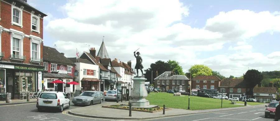
Westerham is a small town of around 4,500 people, tucked under the North Downs in the Sevenoaks district of Kent, close to the Surrey border. It is the kind of place where the green at the centre does a lot of the work: pubs around the edge, a Co-op a minute away, a pharmacy on the doorstep and a hall that doubles as a cinema club.
It is green, quiet and well kept, and it suits people who want a slower pace with countryside on all sides. Farley Common and The Long Pond are both within half a mile, and the lanes out towards Crockham Hill and Toy's Hill are proper walking country.
Be honest with yourself about the trade-offs before you swap. This is a town without its own railway station, with one supermarket and a short parade of shops rather than a high street full of chains. If you want big-town choice on your doorstep, Westerham will feel small. If you want air, space and neighbours who know each other, it may be exactly right.
Swapping to Westerham: key facts
Can I swap my council or housing association home to Westerham?
Yes, if you are already a council or housing association tenant. Mutual exchange means swapping homes with another social tenant, so it does not depend on the council waiting list: you need a tenant in or near Westerham who wants your area, and both landlords must agree. Landlords have 42 days to decide and can only refuse on set legal grounds.
How long is the council housing waiting list in Westerham?
1,016 households were on the Sevenoaks housing register on 31 March 2025, up 4% on a year earlier. 270 social homes were let through the council in 2024 to 2025, roughly 3.8 households for every home let. Source: Local Authority Housing Statistics, Ministry of Housing, Communities and Local Government.
How much is social rent in Westerham?
Average weekly social rents in the Sevenoaks council area in 2024/25: 1 bed £0 council, £112 housing association; 2 bed £0 council, £130 housing association; 3 bed £0 council, £143 housing association. Affordable rent homes cost more, typically 60 to 80% of market rent. Source: Regulator of Social Housing.
How much social housing is there in Westerham and who owns it?
13.2% of homes in the Sevenoaks council area are social housing (council 2%, housing association 11.2%), against 17.1% across England, according to the 2021 Census. The biggest social landlords there are West Kent Housing Association (5,793 homes), Moat Homes Limited (983 homes) and Places for People Homes Limited (164 homes).
How Busy Is The Swap Market In Westerham?
Figures as of 21 October 2026, updated every night. The waiting list figure is from 2024 to 2025 government data.
Which homes are available to swap near Westerham?
Homes are shown near their address, not on it. Contains OS data © Crown copyright and database right. Source: Office for National Statistics, Open Government Licence.
No homes listed within 5 miles at the moment. New homes are listed every week: see homes across Kent, use the alert form below, or list your own home so tenants here can find you.
What is housing like in Westerham and who lives there?
Westerham is largely a home-owning town in a home-owning district. Across the Sevenoaks area, 71.5% of homes are owned outright or with a mortgage, 13.4% are privately rented, and 13.2% are social rented, which is below the England figure of 17.1%. Only 2% is council-owned, with 11.2% held by housing associations.
That makes the housing associations the main social landlords here. West Kent Housing Association is by far the biggest with 5,793 homes in the district, followed by Moat Homes with 983, Places for People Homes with 164, Rockdale Housing Association with 124 and Orbit with 96.
Social rents in the Sevenoaks area averaged £112 a week for a one bed, £130 for two beds and £143 for three beds in 2024/25, which is good value for this part of Kent. Social housing is not plentiful locally: 1,016 households were on the council's register at 31 March 2025 and 270 homes were let through the council in 2024-25. A register is not a simple queue, and a mutual exchange is a separate route.
Council waiting list and lettings
Households on the register by the size of home they need.
That is roughly 3.8 households waiting for every social home let in a year. Mutual exchange doesn't use the waiting list: if you already have a council or housing association home, swapping with another tenant can be a quicker way to move to Westerham.
A register counts households who have applied, so it isn't a simple queue: some are already social tenants hoping to transfer, and people can be on more than one council's list.
Typical weekly social rents in the Sevenoaks council area
| Size | Council | Housing association |
|---|---|---|
| Bedsit | £0 | £0 |
| 1 bed | £0 | £112 |
| 2 bed | £0 | £130 |
| 3 bed | £0 | £143 |
| 4 bed | £0 | £160 |
Social rent averages for 2024/25. Affordable rent homes cost more, typically 60 to 80% of market rent.
Biggest social landlords in the council area
- West Kent Housing Association5,793 homes
- Moat Homes Limited983 homes
- Places for People Homes Limited164 homes
- Rockdale Housing Association Limited124 homes
- Orbit Housing Association Limited96 homes
- Orbit Group Limited92 homes
- Anchor Hanover Group83 homes
- The Riverside Group Limited37 homes
What is it like to live in Westerham?
Day to day, life is compact. The Co-op is about a minute from the green, the Day Lewis Pharmacy is right in the centre, and Westerham Hall hosts the Fleapit Cinema Club as well as community events. Everything else tends to mean a bus or a car.
The wider Sevenoaks area skews a little older than England as a whole: 21.5% are 65 or over and 27.5% are between 45 and 64, with slightly fewer young adults. In Westerham itself that shows in the pace of things. It is friendly, but it is not lively after dark beyond the pubs.
What are the schools and family life like in Westerham?
Families are reasonably well served for a town this size. Churchill Church of England Voluntary Controlled Primary School is only about 0.3 miles away, so it is a walk for most of the town. Further out there are Crockham Hill CofE Primary at 2.1 miles, Sundridge and Brasted CofE Primary at 2.4 miles, Limpsfield CofE Infant School at 2.4 miles and Tatsfield Primary at 2.7 miles.
Secondary choice nearby is more limited and specialised. Valence School is 0.9 miles away, Limpsfield Grange School is 2.7 miles, and Radnor House Sevenoaks at 2.3 miles and Hazelwood School at 3 miles are independent. For most children, secondary school is likely to mean a journey out of the town, so check catchments, admissions and school transport carefully before swapping.
For younger children, the green, The Long Pond and Farley Common are easy free days out, and Westerham Hall and nearby village halls at Crockham Hill and Toy's Hill host community activities. Across the Sevenoaks area, 19.6% of residents are under 16, a shade above the England figure.
Primary schools
- Churchill Church of England Voluntary Controlled Primary School0.3 mi
- Crockham Hill Church of England Voluntary Controlled Primary School2.1 mi
- Sundridge and Brasted Church of England Voluntary Controlled Primary School2.4 mi
- Limpsfield CofE Infant School2.4 mi
- Tatsfield Primary School2.7 mi
Secondary schools
- Valence School0.9 mi
- Radnor House Sevenoaks2.3 mi
- Limpsfield Grange School2.7 mi
- Hazelwood School3 mi
Parks
- The Long Pond0.3 mi
- Farley Common0.5 mi
- Tatsfield Green2.4 mi
- Westmore Green2.8 mi
What shops and everyday essentials are in Westerham?
Supermarkets
- Co-op Foodnearby
Pharmacies
- Day Lewis Pharmacynearby
How do you get around Westerham?
Westerham Green is the local bus hub, right in the middle of town, and it is the main public transport option here. Buses connect the town with the surrounding area, so check the exact routes and times for the places you need regularly, especially for evenings and Sundays, before you commit to a swap.
There is no railway station in Westerham itself, so train journeys mean travelling to a station elsewhere first, usually by bus or car. That is the single biggest thing to plan around if you commute by rail.
On foot, the centre works well. The Co-op, pharmacy, pubs, Westerham Hall and the nearest primary school are all within half a mile, and footpaths lead straight out onto Farley Common and the surrounding hills. A car makes life considerably easier for bigger shops, hospital trips and work outside the town, and many households here rely on one. If you do not drive, build your week around the bus timetable and be realistic about it.
Bus stations
- Westerham Greennearby
What is there to do in Westerham?
Westerham's social life revolves around the green and the pubs. The George and Dragon and Grasshopper On The Green are right there, the General Wolfe is 0.3 miles away, and the Grasshopper Inn and Stanhope Arms are a short drive out at 1.1 and 1.6 miles.
The Fleapit Cinema Club at Westerham Hall is a genuine local treat: a proper community cinema a minute from the centre, rather than a multiplex trip. The hall itself is the hub for groups and events, and there are more village halls at Crockham Hill, Toy's Hill and Ide within about three miles, plus 1st Tatsfield Scouts for children.
Outdoors is the real draw. The Long Pond and Farley Common are both under half a mile, and Tatsfield Green and Westmore Green sit a couple of miles out. The countryside between them is laced with footpaths and hills, which makes walking, running and dog-walking the default local hobby. If you want shopping centres, gyms and nightlife, you will be travelling for them.
Cinemas
- Fleapit Cinema Club (at Westerham Hall)nearby
Pubs and bars
- The George and Dragonnearby
- Grasshopper On The Greennearby
- General Wolfe0.3 mi
- The Grasshopper Inn1.1 mi
- Stanhope Arms1.6 mi
Community centres
- Westerham Hallnearby
- Crockham Hill Village Hall2.1 mi
- Toy's Hill Hall2.2 mi
- 1st Tatsfield Scouts2.8 mi
- Ide Village Hall3 mi
What is work and the local economy like in Westerham?
The Sevenoaks area is a relatively prosperous corner of the South East and the employment figures reflect it. Around 58.4% of adults are in work, slightly above the England average of 57.4%, while unemployment sits at 2.4% against 3.5% nationally. In August 2026, 2.3% of 16 to 64 year olds were claiming unemployment-related benefits, compared with 4% across England.
In Westerham itself, local jobs are mostly small-scale: shops, pubs, the pharmacy, schools, care and services for the surrounding villages. It is not a town with one big employer.
So most working people here commute. With no station in town, that usually means driving, or a bus to a larger centre and a train on from there. If you work shifts or unsociable hours, check what is actually running at those times rather than assuming. Working from home suits Westerham well, and plenty do it, but confirm broadband speed at the specific address before you agree to a swap.
Figures are for the Sevenoaks council area, Census 2021 and ONS claimant count.
How safe is Westerham?
Like every town centre, Westerham has police incidents logged each month. In August 2026 there were 56 within about a mile of the centre, made up of:
- Anti-social behaviour reports16
- Vehicle crime5
- Shoplifting2
- Other theft10
- Criminal damage2
- Burglary1
Source: data.police.uk street-level crime. Counts cover a fixed one-mile radius around the centre, so busy high streets and stations always record far more than the residential streets around them, and most incidents are minor. Compare like with like: a similar-sized town centre, not a village.
Is Westerham a good place for social housing tenants?
If Westerham sounds like your sort of place, a mutual exchange is often the most realistic way in. Social homes do not come up here in great numbers, so swapping directly with another tenant puts you in control rather than waiting on a list.
The practical step is simple. List your own home on Mutual Home Exchange, free, with clear photos and an honest description of the rooms, garden, parking and any repairs. Then set Westerham, or the TN16 area, as a desired area so tenants there can find you. Add the nearby villages too if you would consider them, as that widens your chances a lot.
Before you commit, visit on a weekday and a weekend. Walk from the property to the Co-op, the pharmacy and the bus stop at Westerham Green, and time the journeys you would make every week. Check school places and transport for your children. Both landlords have to approve the swap, so talk to yours early. Take your time: a good match is worth waiting for.
Tell me when a home appears near Westerham
One email, the first time a council or housing association home is listed within your chosen distance. No newsletter, no spam.
Live in Westerham? Add a photo
Tenants' own photos help other people picture the place. Approved photos are credited to you. Submit a photo.
Nearby place guides
Thinking of moving a little further? Compare homes to swap, rents and local landlords in places near Westerham.
All place guides in Kent → · All place guides in the South East → · All regions →