What it's like to live in Thetford
Thetford is a busy market town of around 25,000 people in the Breckland district of Norfolk, with a compact centre, plenty of post-war housing estates and forest and common land on the doorstep. It suits families and anyone who wants town amenities without big-city prices. Castle Park and Abbey Meadows are both a short stroll from the middle of town.
"I'd move here" adds Thetford to the areas on your listing, so homes here are matched to you first.
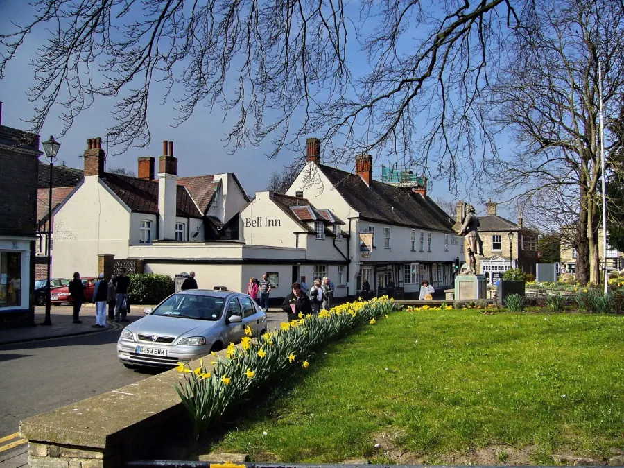
Thetford sits in south Norfolk, in the Breckland district, close to the Suffolk border. Norwich, Bury St Edmunds and Cambridge are the larger centres people look to for work, shopping and hospitals, and Thetford is one of the few towns of its size in the area with its own railway station.
People move here for space and value. Social rents across Breckland are modest compared with much of the East of England, and the town has a good spread of two and three bedroom family homes. It has long taken in households from London and from bigger East Anglian cities, which has given it a mixed, friendly population.
The other big draw is the setting. Thetford Forest and the Brecks heathland wrap around the town, so open country is minutes away even though you are in a place with a cinema, a bus interchange, several supermarkets and a decent run of schools. If you want a town that feels manageable but not cut off, Thetford is worth a serious look.
Swapping to Thetford: key facts
Can I swap my council or housing association home to Thetford?
Yes, if you are already a council or housing association tenant. Mutual exchange means swapping homes with another social tenant, so it does not depend on the council waiting list: you need a tenant in or near Thetford who wants your area, and both landlords must agree. Landlords have 42 days to decide and can only refuse on set legal grounds.
How long is the council housing waiting list in Thetford?
1,089 households were on the Breckland housing register on 31 March 2025, down 25% on a year earlier. 637 social homes were let through the council in 2024 to 2025, roughly 1.7 households for every home let. Source: Local Authority Housing Statistics, Ministry of Housing, Communities and Local Government.
How much is social rent in Thetford?
Average weekly social rents in the Breckland council area in 2024/25: 1 bed £181 council, £92 housing association; 2 bed £131 council, £107 housing association; 3 bed £181 council, £115 housing association. Affordable rent homes cost more, typically 60 to 80% of market rent. Source: Regulator of Social Housing.
How much social housing is there in Thetford and who owns it?
14.1% of homes in the Breckland council area are social housing (council 2.7%, housing association 11.4%), against 17.1% across England, according to the 2021 Census. The biggest social landlords there are Flagship Housing Limited (6,749 homes), Broadland Housing Association Limited (619 homes) and Orbit Housing Association Limited (499 homes).
How Busy Is The Swap Market In Thetford?
Figures as of 23 October 2026, updated every night. The waiting list figure is from 2024 to 2025 government data.
Which homes are available to swap near Thetford?
Homes are shown near their address, not on it. Contains OS data © Crown copyright and database right. Source: Office for National Statistics, Open Government Licence.
No homes listed within 5 miles at the moment. New homes are listed every week: see homes across Norfolk, use the alert form below, or list your own home so tenants here can find you.
What is housing like in Thetford and who lives there?
Breckland has a smaller social rented sector than England as a whole: 14.1% of homes, made up of 2.7% council and 11.4% housing association, against 17.1% nationally. Owner-occupation is high at 67%, with 18.1% privately rented. Thetford itself, with its large post-war estates, holds a bigger share of the district's social housing than the villages do.
Rents are among the attractions. Average weekly social rents across the council area in 2024/25 were about £92 for a one bed, £107 for two beds and £116 for three beds.
Flagship Housing is far and away the largest social landlord locally with around 6,749 homes, followed by Broadland Housing Association, Orbit, Saffron Housing Trust and Clarion. Breckland's council housing register held 1,089 households at the end of March 2025, with 637 social homes let through the council in 2024-25; a register is not a simple queue. The age profile skews older than England's, though Thetford's estates tend to be younger and more family-heavy than the surrounding countryside.
Council waiting list and lettings
Households on the register by the size of home they need.
That is roughly 1.7 households waiting for every social home let in a year. Mutual exchange doesn't use the waiting list: if you already have a council or housing association home, swapping with another tenant can be a quicker way to move to Thetford.
A register counts households who have applied, so it isn't a simple queue: some are already social tenants hoping to transfer, and people can be on more than one council's list.
Typical weekly social rents in the Breckland council area
| Size | Council | Housing association |
|---|---|---|
| Bedsit | £183 | £78 |
| 1 bed | £181 | £92 |
| 2 bed | £131 | £107 |
| 3 bed | £181 | £115 |
| 4 bed | £132 | £126 |
Social rent averages for 2024/25. Affordable rent homes cost more, typically 60 to 80% of market rent.
Biggest social landlords in the council area
- Flagship Housing Limited6,749 homes
- Broadland Housing Association Limited619 homes
- Orbit Housing Association Limited499 homes
- Saffron Housing Trust Limited410 homes
- Clarion Housing Association Limited196 homes
- Places for People Living+ Limited195 homes
- Havebury Homes193 homes
- Places for People Homes Limited158 homes
What is it like to live in Thetford?
Day to day, most of what you need sits close together. The town centre has Roys and Aldi, smaller independents like Biedronka Supermarket and Monte Cristo, and a cluster of pharmacies on and around Tanner Street and School Lane. A bigger Tesco sits about a mile out. Thetford Library is right in the centre.
The town is a mix of old and new. Streets near the centre are walkable and flat, while estates such as Redcastle Furze and Abbey have their own neighbourhood centres. Green space is never far: Boudicca Pocket Park, Castle Park, and the Upper and Lower Melford Commons are all within half a mile of the middle. It is a working town rather than a picture-postcard one, and people who settle here tend to like that.
What are the schools and family life like in Thetford?
For a town of 25,000, Thetford is well served for schools. Within a short distance of the centre you will find Norwich Road Academy, Queensway Infant and Junior Academies, Drake Primary School and Redcastle Family School, so most estates have a primary within pram-pushing range. Check current admissions and Ofsted reports for yourself, as catchments and places change year to year.
At secondary level there is The Thetford Academy about a mile out, plus The Damara School, The Pinetree School and Compass Community School Eld Park closer in. Between them the town covers mainstream and specialist provision without a long bus journey.
Family life leans on the outdoors and on community buildings. Castle Park, Abbey Meadows and the two Melford Commons give children somewhere to run, and Thetford Library is a short walk from the centre for story times and free activities. Redcastle Furze Community Centre, Abbey Neighbourhood Centre, Magdalen Street Centre and the Charles Burrell Centre host local groups. Across Breckland, 16.6% of residents are under 16, a little below the England average.
Primary schools
- Norwich Road Academynearby
- Queensway Junior Academy0.5 mi
- Queensway Infant Academy0.6 mi
- Drake Primary School0.6 mi
- Redcastle Family School0.6 mi
Secondary schools
- The Damara Schoolnearby
- The Pinetree School0.7 mi
- Compass Community School Eld Park0.7 mi
- The Thetford Academy1.1 mi
Parks
- Boudicca Pocket Parknearby
- Castle Parknearby
- Upper Melford Common0.3 mi
- Lower Melford Common0.4 mi
- Abbey Meadows0.5 mi
Libraries
- Thetford Librarynearby
What shops and everyday essentials are in Thetford?
Supermarkets
- Biedronka Supermarket Ltdnearby
- Roysnearby
- Aldinearby
- Monte Cristonearby
- Tesco1 mi
Pharmacies
- Tanner Street Pharmacynearby
- Lime Pharmacynearby
- School Lane Pharmacynearby
- Healthy Living Pharmacy0.5 mi
- Tesco Pharmacy1 mi
How do you get around Thetford?
Thetford station is about a third of a mile from the centre, which is a real advantage for a town this size. It puts Norwich, Ely and Cambridge within reach without a car, and makes commuting or visiting family far easier than in most Breckland villages.
Buses run from Thetford Bus Interchange, roughly a quarter of a mile from the middle of town, linking local estates with the centre and with surrounding towns. Check specific routes and evening times before you commit, as rural services vary and some run less often at weekends.
By car, Thetford sits on the main road corridor between Norwich and the Midlands, so getting out of town is straightforward, though the through-traffic can be heavy at peak times. On foot, the central area is flat and compact: library, pharmacies, supermarkets, cinema and parks are mostly within half a mile of each other. Outlying estates are a longer but walkable trip in, and cycling is popular given the level ground and the forest tracks nearby.
Train stations
- Thetford0.4 mi
Bus stations
- Thetford Bus Interchange0.3 mi
What is there to do in Thetford?
Thetford punches above its weight for a town this size. The Light cinema is right in the centre, a couple of minutes from the shops, and there is a good choice of gyms including New Revolution, Snap Fitness, CBC Fitness Studio, Tiger Fitness and RFA Gym within about a mile.
For a drink or a meal out, the older pubs cluster in and around the centre: The Red Lion, Green Dragon, Black Horse, The Bell Inn and The Albion are all within a few minutes' walk. Ice provides a late-night option if you want one.
Green space is the town's strongest card. Castle Park, Boudicca Pocket Park, Abbey Meadows and the Upper and Lower Melford Commons are all close to the centre, and the wider Brecks countryside surrounds the town for longer walks and bike rides. Thetford Library and the community centres dotted around the estates carry much of the town's cultural and club life, from groups and classes to community events.
Gyms
- New Revolutionnearby
- Snap Fitnessnearby
- CBC Fitness Studio0.7 mi
- Tiger Fitness0.7 mi
- RFA Gym1 mi
Cinemas
- The Lightnearby
Pubs and bars
- The Red Lionnearby
- Green Dragonnearby
- Black Horsenearby
- The Bell Innnearby
- The Albionnearby
Nightlife
- Icenearby
Community centres
- Thetford Islamic Centernearby
- Magdalen Street Centre0.3 mi
- Redcastle Furze Community Centre0.6 mi
- Abbey Neighbourhood Centre0.8 mi
- Charles Burrell Centre0.8 mi
What is work and the local economy like in Thetford?
Employment figures cover the wider Breckland council area rather than Thetford alone. Here, 55.7% of adults are in work, just under the England figure of 57.4%, while unemployment stands at 2.4% against 3.5% nationally. Unemployment-related benefit claims were 2.6% of working-age residents in September 2026, below the England rate of 4%.
That suggests a steady local jobs picture, though Breckland's older age profile, with a quarter of residents aged 65 and over, pulls the employment rate down a little. Many working households combine local jobs with commuting.
Thetford's own economy mixes retail and services in the town centre with industrial and distribution work on the edges of town. The railway station and the main road links widen the options considerably: Norwich, Bury St Edmunds, Ely and Cambridge are all realistic commutes by train or car. If your job can be done from home some of the week, the combination of low rents and reasonable connections is one of the practical reasons people choose Thetford.
Figures are for the Breckland council area, Census 2021 and ONS claimant count.
How safe is Thetford?
Like every town centre, Thetford has police incidents logged each month. In August 2026 there were 211 within about a mile of the centre, made up of:
- Anti-social behaviour reports27
- Bicycle theft2
- Shoplifting10
- Other theft6
- Criminal damage24
- Burglary6
Source: data.police.uk street-level crime. Counts cover a fixed one-mile radius around the centre, so busy high streets and stations always record far more than the residential streets around them, and most incidents are minor. Compare like with like: a similar-sized town centre, not a village.
Is Thetford a good place for social housing tenants?
If Thetford sounds like it could work for you, the practical next step is to get your own home listed. A clear advert with honest photos, the number of bedrooms, the floor or house type, your rent and anything a swapper would want to know about the area does far more than a short one-liner.
Then set Thetford as a desired area on your profile. You can add nearby places too, and it is worth being specific about what matters: a particular school run, a ground-floor flat, or being within walking distance of the station or the bus interchange.
After that, keep an eye on new listings and message people yourself rather than waiting. Swaps often come together because someone made the first approach. Before you agree anything, visit the property, walk the streets at different times of day, and check with both landlords that they will approve the exchange. Thetford rewards a bit of homework: the estates differ in feel, and seeing them for yourself is the only way to know which one suits your household.
Tell me when a home appears near Thetford
One email, the first time a council or housing association home is listed within your chosen distance. No newsletter, no spam.
Live in Thetford? Add a photo
Tenants' own photos help other people picture the place. Approved photos are credited to you. Submit a photo.
Nearby place guides
Thinking of moving a little further? Compare homes to swap, rents and local landlords in places near Thetford.
All place guides in Norfolk → · All place guides in the East of England → · All regions →