What it's like to live in Cromer
Cromer is a small seaside town on the North Norfolk coast, home to around 7,500 people, with cliffs, a pier and a compact centre of narrow streets. It suits people who want a slower pace, sea air and a proper town centre within walking distance. Cromer and District Hospital and the Regal Movieplex are both close by, which is rare for a town this size.
"I'd move here" adds Cromer to the areas on your listing, so homes here are matched to you first.
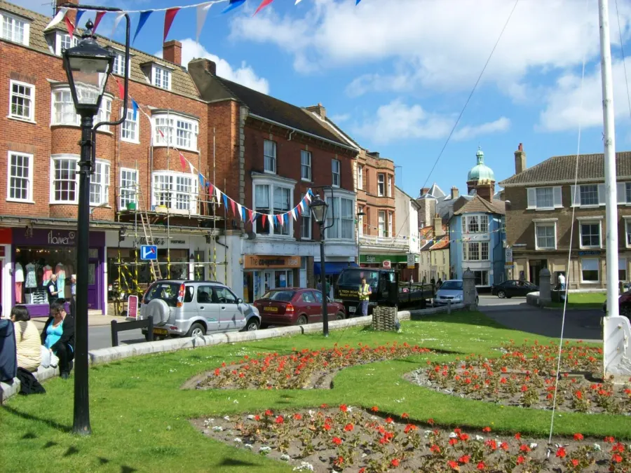
Cromer sits on the north Norfolk coast, in the North Norfolk district. It is one of the larger coastal towns on this stretch, with smaller villages such as East Runton, West Runton, Northrepps and Roughton scattered around it. Norwich is the nearest big city, and the town's postcode district is NR27.
People move here for the coast and for the fact that Cromer is a working town rather than just a holiday spot. It has its own hospital, library, cinema, bus hub and railway station, which means you are not reliant on travelling elsewhere for the basics. That combination is what tends to pull tenants towards a swap here.
It is worth being honest about the trade-off. North Norfolk is a rural district with an older population than England as a whole, and Cromer is a small town, not a city. If you want a wide choice of jobs, nightlife and large shopping centres on your doorstep, this is not that place. If you want sea, space and a tight-knit town, it may suit you very well.
Swapping to Cromer: key facts
Can I swap my council or housing association home to Cromer?
Yes, if you are already a council or housing association tenant. Mutual exchange means swapping homes with another social tenant, so it does not depend on the council waiting list: you need a tenant in or near Cromer who wants your area, and both landlords must agree. Landlords have 42 days to decide and can only refuse on set legal grounds.
How long is the council housing waiting list in Cromer?
2,199 households were on the North Norfolk housing register on 31 March 2025, down 11% on a year earlier. 284 social homes were let through the council in 2024 to 2025, roughly 7.7 households for every home let. Source: Local Authority Housing Statistics, Ministry of Housing, Communities and Local Government.
How much is social rent in Cromer?
Average weekly social rents in the North Norfolk council area in 2024/25: 1 bed £0 council, £92 housing association; 2 bed £0 council, £107 housing association; 3 bed £0 council, £115 housing association. Affordable rent homes cost more, typically 60 to 80% of market rent. Source: Regulator of Social Housing.
How much social housing is there in Cromer and who owns it?
13% of homes in the North Norfolk council area are social housing (council 2.1%, housing association 10.9%), against 17.1% across England, according to the 2021 Census. The biggest social landlords there are Flagship Housing Limited (5,052 homes), Broadland Housing Association Limited (541 homes) and Clarion Housing Association Limited (234 homes).
How Busy Is The Swap Market In Cromer?
Figures as of 23 October 2026, updated every night. The waiting list figure is from 2024 to 2025 government data.
Which homes are available to swap near Cromer?
Homes are shown near their address, not on it. Contains OS data © Crown copyright and database right. Source: Office for National Statistics, Open Government Licence.
No homes listed within 5 miles at the moment. New homes are listed every week: see homes across Norfolk, use the alert form below, or list your own home so tenants here can find you.
What is housing like in Cromer and who lives there?
North Norfolk has a smaller social housing sector than England as a whole: 13% of homes are socially rented against 17.1% nationally, split between 2.1% council and 10.9% housing association. Owner occupation is high at 68.7%, and 17.6% of homes are privately rented, which is above average and reflects the coastal location.
Flagship Housing Limited is by far the biggest social landlord in the district with over 5,000 homes, followed by Broadland Housing Association with 541, then Clarion, Orbit and Places for People. Average weekly social rents in the council area for 2024/25 were £92 for a one bed, £107 for a two bed and £115 for a three bed, which is modest by national standards.
The district's age profile shapes who your neighbours will be: 33.5% are 65 or over and only 13.4% are under 16, so there are fewer children about than in most of England. North Norfolk's housing register held 2,199 households at March 2025, with 284 social homes let through the council in 2024-25, so a mutual exchange is often the more realistic route.
Council waiting list and lettings
Households on the register by the size of home they need.
That is roughly 7.7 households waiting for every social home let in a year. Mutual exchange doesn't use the waiting list: if you already have a council or housing association home, swapping with another tenant can be a quicker way to move to Cromer.
A register counts households who have applied, so it isn't a simple queue: some are already social tenants hoping to transfer, and people can be on more than one council's list.
Typical weekly social rents in the North Norfolk council area
| Size | Council | Housing association |
|---|---|---|
| Bedsit | £0 | £91 |
| 1 bed | £0 | £92 |
| 2 bed | £0 | £107 |
| 3 bed | £0 | £115 |
| 4 bed | £0 | £126 |
Social rent averages for 2024/25. Affordable rent homes cost more, typically 60 to 80% of market rent.
Biggest social landlords in the council area
- Flagship Housing Limited5,052 homes
- Broadland Housing Association Limited541 homes
- Clarion Housing Association Limited234 homes
- Orbit Housing Association Limited207 homes
- Places for People Homes Limited109 homes
- Housing 2193 homes
- Places for People Living+ Limited90 homes
- Saffron Housing Trust Limited42 homes
What is it like to live in Cromer?
Day to day, most things sit tightly together. There is a Co-op Food and Church Street Pharmacy in the centre, with Morrisons, Sainsbury's and Lidl all within half a mile, so a weekly shop does not need a long trip. Boots is right in the middle of town and Cromer Library is a couple of minutes' walk away.
The Cromer Hall Sculpture Walk is the main green space within a few miles, and Cromer Community Centre sits in the town itself. Nearby villages have their own halls, including East Runton, West Runton, Aylmerton and Roughton. Winter is quieter than summer here, and some people love that while others find it too still.
What are the schools and family life like in Cromer?
For primary age, Suffield Park Infant and Nursery School and Cromer Junior School are both about three quarters of a mile from the centre, with Argyll House School a little over a mile away. Slightly further out you have The Belfry Church of England Voluntary Aided Primary School and Northrepps Primary School, both within two and a half miles.
For older children, Cromer Academy is the main secondary school and is roughly half a mile away. Beeston Hall School and Sidestrand Hall School are also within three miles. Suffield Park includes nursery provision, which helps if you have younger children as well.
Family life here leans on the outdoors and on community spaces. Cromer Community Centre is in the town, and the village halls at East Runton, West Runton, Aylmerton and Roughton often host local activities. Cromer Library is a short walk from the centre and is a useful free indoor option in winter. Cromer and District Hospital being under a mile away is reassuring with children in tow.
Primary schools
- Suffield Park Infant and Nursery School0.7 mi
- Cromer Junior School0.7 mi
- Argyll House School1.1 mi
- The Belfry Church of England Voluntary Aided Primary School1.8 mi
- Northrepps Primary School2.4 mi
Secondary schools
- Cromer Academy0.6 mi
- Beeston Hall School2.7 mi
- Sidestrand Hall School2.9 mi
Parks
- Cromer Hall Sculpture Walk0.8 mi
Libraries
- Cromer Librarynearby
What shops and everyday essentials are in Cromer?
Supermarkets
- Co-op Foodnearby
- Morrisons0.3 mi
- Sainsbury's0.5 mi
- Lidl0.6 mi
Pharmacies
- Bootsnearby
- Church Street Pharmacynearby
- Cromer Pharmacy0.6 mi
Hospitals
- Cromer and District Hospital0.7 mi
How do you get around Cromer?
Cromer station is about a third of a mile from the centre, with Roughton Road station under a mile away and West Runton a couple of miles along the coast. Having two stations inside a mile is unusual for a town this size and gives you a rail option without needing a car.
Cromer Travel Hub sits right in the town centre, around a tenth of a mile from the main shops, so buses are easy to pick up for trips to surrounding villages and further afield. As with most of rural Norfolk, services thin out in the evenings and on Sundays, so check the timetable for the journeys you make regularly before you commit to a swap.
On foot, Cromer is genuinely walkable. The supermarkets, pharmacies, library, cinema and hospital are all within a mile of the centre. Roads here are mostly A and B routes rather than motorways, so driving to Norwich or inland takes longer than the mileage suggests, especially in summer when visitors arrive.
Train stations
- Cromer0.3 mi
- Roughton Road0.9 mi
- West Runton2.2 mi
Bus stations
- Cromer Travel Hubnearby
What is there to do in Cromer?
The coast is the main draw, and the Cromer Hall Sculpture Walk, under a mile out, gives you a green space to stretch your legs away from the seafront. Beyond that, formal parks are thin on the ground, so most outdoor time here means beaches, cliff paths and the surrounding countryside.
For a town of this size, the indoor options are decent. The Regal Movieplex cinema is in the centre, and Cromer Library is almost next door. Both are walkable from most of the town, which matters on a wet February evening.
There is a solid cluster of pubs in the middle of town, including The Albion, The White Horse, The Wellington Freehouse and the Kings Head, plus Cromer Social Club. They are all within a few minutes' walk of each other and of the bus hub. Cromer Community Centre and the village halls nearby round out the picture for clubs, groups and one-off events. It is a town where you make your own entertainment and get to know faces quickly.
Cinemas
- Regal Movieplexnearby
Pubs and bars
- The Albionnearby
- The White Horsenearby
- The Wellington Freehousenearby
- Cromer Social Clubnearby
- Kings Headnearby
Community centres
- Cromer Community Centrenearby
- East Runton Village Hall1.3 mi
- West Runton Church Hall2.3 mi
- Aylmerton Village Hall2.7 mi
- Roughton Village Hall2.7 mi
What is work and the local economy like in Cromer?
Be realistic about work before you swap. Across the North Norfolk council area, 46.7% of adults are in work, well below the England figure of 57.4%. That is largely down to the age profile rather than a jobs crisis: a third of residents are 65 or over, so many are retired.
Unemployment in the district is actually lower than average, at 2.2% against 3.5% for England, and unemployment-related benefit claims stood at 2.7% of working-age people in September 2026, compared with 4% nationally. So people who want work generally find it, but the choice of roles is narrower than in a city.
Locally, the big visible employers in Cromer itself are the sorts you would expect in a coastal town with a hospital, schools, supermarkets, pubs and a cinema: health, education, retail and hospitality. Seasonal work is a real feature of the coast, which can mean busy summers and quieter winters. If your job is specialist, check what the commute to Norwich looks like by train or car first.
Figures are for the North Norfolk council area, Census 2021 and ONS claimant count.
How safe is Cromer?
Like every town centre, Cromer has police incidents logged each month. In August 2026 there were 62 within about a mile of the centre, made up of:
- Anti-social behaviour reports8
- Shoplifting4
- Other theft6
- Criminal damage8
- Burglary1
- Drug offences3
Source: data.police.uk street-level crime. Counts cover a fixed one-mile radius around the centre, so busy high streets and stations always record far more than the residential streets around them, and most incidents are minor. Compare like with like: a similar-sized town centre, not a village.
Is Cromer a good place for social housing tenants?
If Cromer sounds like the right fit, the practical next step is to list your own home on Mutual Home Exchange and set Cromer, or the NR27 postcode district, as a desired area. Listing is free for council and housing association tenants, and a clear, honest advert with good photos does most of the work for you.
It helps to be flexible about the surrounding area too. Adding nearby villages such as East Runton, West Runton, Northrepps or Roughton widens your options, and several of them are still within a short bus or car journey of Cromer's shops, station and hospital.
Before you agree anything, visit at different times of year if you can. A coastal town in August feels very different from the same town in January, and it is worth knowing which version you are signing up for. Check the bus and train times for your own regular journeys, look at school places, and speak to your landlord early about their exchange process so there are no surprises later.
Tell me when a home appears near Cromer
One email, the first time a council or housing association home is listed within your chosen distance. No newsletter, no spam.
Live in Cromer? Add a photo
Tenants' own photos help other people picture the place. Approved photos are credited to you. Submit a photo.
Nearby place guides
Thinking of moving a little further? Compare homes to swap, rents and local landlords in places near Cromer.
All place guides in Norfolk → · All place guides in the East of England → · All regions →