What it's like to live in Leatherhead
Leatherhead is a small Surrey town of around 11,300 people in Mole Valley, with a compact centre, the River Mole running through and the North Downs on the doorstep. It suits families and anyone who wants town shops and a train station close by without living in a city. Mansion Gardens and the wide open space of Ashtead Common are both nearby plus points.
"I'd move here" adds Leatherhead to the areas on your listing, so homes here are matched to you first.
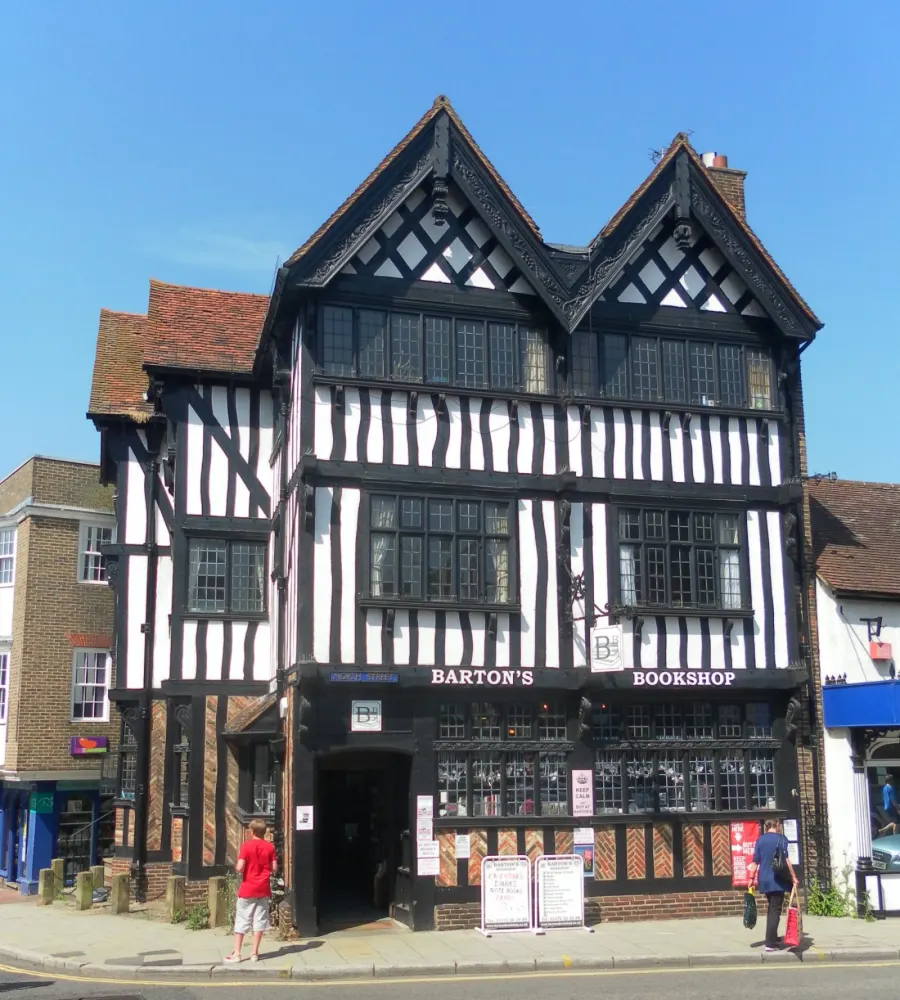
Leatherhead sits in the Mole Valley district of Surrey, tucked between the North Downs and the commuter belt south of London. Ashtead is under two miles away, Bookham a little over two, and Cobham and Dorking are both within easy reach. The wider Mole Valley council area has a population of about 87,400, so this is a district of towns and villages rather than a big urban sprawl.
People move here for the combination of a working town centre, fast rail links and countryside that starts almost at the edge of the built-up area. Box Hill & Westhumble station is within three miles, which gives you a sense of how close the Downs are.
For tenants, the draw is usually practical: a decent choice of schools nearby, a hospital and clinic in the town, and the chance to be in Surrey without being miles from shops. Social housing is less common here than in England as a whole, so swaps are worth planning for rather than rushing.
Swapping to Leatherhead: key facts
Can I swap my council or housing association home to Leatherhead?
Yes, if you are already a council or housing association tenant. Mutual exchange means swapping homes with another social tenant, so it does not depend on the council waiting list: you need a tenant in or near Leatherhead who wants your area, and both landlords must agree. Landlords have 42 days to decide and can only refuse on set legal grounds.
How long is the council housing waiting list in Leatherhead?
653 households were on the Mole Valley housing register on 31 March 2025, down 4% on a year earlier. 205 social homes were let through the council in 2024 to 2025, roughly 3.2 households for every home let. Source: Local Authority Housing Statistics, Ministry of Housing, Communities and Local Government.
How much is social rent in Leatherhead?
Average weekly social rents in the Mole Valley council area in 2024/25: 1 bed £0 council, £119 housing association; 2 bed £0 council, £141 housing association; 3 bed £0 council, £157 housing association. Affordable rent homes cost more, typically 60 to 80% of market rent. Source: Regulator of Social Housing.
How much social housing is there in Leatherhead and who owns it?
11.7% of homes in the Mole Valley council area are social housing (council 1.5%, housing association 10.1%), against 17.1% across England, according to the 2021 Census. The biggest social landlords there are Clarion Housing Association Limited (3,619 homes), Mount Green Housing Association Limited (450 homes) and Southern Housing (104 homes).
How Busy Is The Swap Market In Leatherhead?
Figures as of 23 October 2026, updated every night. The waiting list figure is from 2024 to 2025 government data.
Which homes are available to swap near Leatherhead?
Homes are shown near their address, not on it. Contains OS data © Crown copyright and database right. Source: Office for National Statistics, Open Government Licence.
No homes listed within 5 miles at the moment. New homes are listed every week: see homes across Surrey, use the alert form below, or list your own home so tenants here can find you.
What is housing like in Leatherhead and who lives there?
Leatherhead sits in a district where owning is the norm. Across Mole Valley, 73.2% of homes are owned outright or with a mortgage, 14.1% are privately rented, and 11.7% are social rented, below the England figure of 17.1%. Of that social housing, most is housing association rather than council: 10.1% against 1.5%.
Clarion Housing Association is by far the biggest social landlord in the area with around 3,619 homes, followed by Mount Green Housing Association with 450, Southern Housing with 104, Metropolitan Housing Trust with 70 and The Grange Centre for People with Disabilities with 62. Average weekly social rents in 2024/25 were £119 for a one bed, £141 for two and £157 for three.
The age profile skews older than England's: 23.8% of Mole Valley residents are 65 or over, against 18.4% nationally, with fewer people aged 25 to 44. Mole Valley's housing register held 653 households at March 2025 and the council let 205 social homes in 2024-25, so a mutual exchange is often the more direct route.
Council waiting list and lettings
Households on the register by the size of home they need.
That is roughly 3.2 households waiting for every social home let in a year. Mutual exchange doesn't use the waiting list: if you already have a council or housing association home, swapping with another tenant can be a quicker way to move to Leatherhead.
A register counts households who have applied, so it isn't a simple queue: some are already social tenants hoping to transfer, and people can be on more than one council's list.
Typical weekly social rents in the Mole Valley council area
| Size | Council | Housing association |
|---|---|---|
| Bedsit | £0 | £121 |
| 1 bed | £0 | £119 |
| 2 bed | £0 | £141 |
| 3 bed | £0 | £157 |
| 4 bed | £0 | £177 |
Social rent averages for 2024/25. Affordable rent homes cost more, typically 60 to 80% of market rent.
Biggest social landlords in the council area
- Clarion Housing Association Limited3,619 homes
- Mount Green Housing Association Limited450 homes
- Southern Housing104 homes
- Metropolitan Housing Trust Limited70 homes
- The Grange Centre for People with Disabilities62 homes
- A2Dominion South Limited62 homes
- Transform Housing & Support61 homes
- Raven Housing Trust Limited41 homes
What is it like to live in Leatherhead?
Day to day, most of what you need sits in a tight cluster. The Swan Centre is the heart of the shopping, with a Lidl, Sainsbury's and Waitrose all within a few minutes of the centre and a Tesco about a mile out. Boots is on the high street and there are more pharmacies dotted around Fetcham and Ashtead.
The town has a proper local feel. Leatherhead Library is a short walk from the centre, the Fairfield Centre and several church and village halls host community groups, and Leatherhead Community Hospital and Leatherhead Clinic are both around half a mile away. Beyond the centre, streets quickly turn greener and quieter as you head towards Fetcham and Ashtead.
What are the schools and family life like in Leatherhead?
There is a good spread of schools close to the centre. Leatherhead Trinity School and Nursery is only 0.3 miles away, with Little Downsend Leatherhead at 0.5 miles, and St Peter's Catholic Primary School, St Andrews and West Hill School all within a mile.
For older children, St John's School is 0.3 miles from the centre, Woodlands School 0.6 miles, and Downsend School, St Andrew's Catholic School and Therfield School all around 0.8 miles. Having several secondaries within walking or short bus distance is a real advantage if you have more than one child at different stages. Check admissions and catchment carefully before committing to a swap.
Family life beyond school is easy to arrange. Mansion Gardens and Common Meadow are both close for after-school runs about, Leatherhead Library is a short walk, and the Fairfield Centre, Fortyfoot Hall and Fetcham Village Hall host local groups. A scout group meets in Ashtead. Across Mole Valley, 17.1% of residents are under 16, slightly below the England figure of 18.6%.
Primary schools
- Leatherhead Trinity School and Nursery0.3 mi
- Little Downsend Leatherhead0.5 mi
- St Peter's Catholic Primary School0.8 mi
- St Andrews0.8 mi
- West Hill School1 mi
Secondary schools
- St John's School0.3 mi
- Woodlands School0.6 mi
- Downsend School0.8 mi
- St Andrew's Catholic School0.8 mi
- Therfield School0.8 mi
Parks
- Mansion Gardensnearby
- Common Meadow0.5 mi
- Beaverbrook1.6 mi
- Ashtead Common1.7 mi
- Chalk Grassland1.8 mi
Libraries
- Leatherhead Librarynearby
- Ashtead Library1.7 mi
- Bookham Library2.3 mi
What shops and everyday essentials are in Leatherhead?
Supermarkets
- Lidlnearby
- Sainsbury'snearby
- Waitrosenearby
- Tesco1.1 mi
- M&S Foodhall1.7 mi
Pharmacies
- Bootsnearby
- Day Lewis Pharmacy0.8 mi
- Buckleys1.5 mi
- LLoyds1.8 mi
- Grove Pharmacy2.3 mi
Hospitals
- Leatherhead Clinic0.5 mi
- Leatherhead Community Hospital0.5 mi
- Ashtead Hospital1.3 mi
- Ashtead Clinic1.7 mi
Shopping centres
- The Swan Centrenearby
How do you get around Leatherhead?
Leatherhead station is about a quarter of a mile from the town centre, which makes rail a realistic option whether or not you drive. Ashtead station is 1.8 miles away, Bookham 2.3 miles, and Cobham & Stoke d'Abernon and Box Hill & Westhumble both sit around 2.9 miles out, so there is more than one way onto the network.
The town centre itself is walkable. Supermarkets, the library, Boots and The Swan Centre are all within a few hundred metres of each other, and Mansion Gardens is a two-minute walk away. If you live in the middle of town, a lot of errands can be done on foot.
By car, Leatherhead is well placed for the wider Surrey road network and for reaching Ashtead, Fetcham, Bookham and Dorking. Parking and traffic in a small town centre can be fiddly at busy times. Bus services link the town with surrounding villages, though timetables are worth checking for the specific route you would rely on.
Train stations
- Leatherheadnearby
- Ashtead1.8 mi
- Bookham2.3 mi
- Cobham & Stoke d'Abernon2.9 mi
- Box Hill & Westhumble2.9 mi
What is there to do in Leatherhead?
Green space is the strongest card here. Mansion Gardens is on the town's doorstep and Common Meadow half a mile out, while Ashtead Common and the chalk grassland of the Downs are under two miles away for longer walks. Beaverbrook, about 1.6 miles out, adds to the open country on this side of town.
In town, The Swan Centre covers the shopping, and there is a cluster of pubs and bars in the centre including The Running Horse, The Penny Black, The Edmund Tylney, Gossip and Beluga. That gives you a decent choice for an evening out without travelling.
For indoor activity, Nuffield Health Fitness & Wellbeing is a short walk from the centre, and Leatherhead Library is handy for free things to do with children. Ashtead and Bookham libraries are both within three miles if you want a change of scene. It is a town where most leisure is local and low-key rather than flashy.
Gyms
- Nuffield Health Fitness & Wellbeingnearby
Pubs and bars
- Gossipnearby
- Beluganearby
- The Penny Blacknearby
- The Running Horsenearby
- The Edmund Tylneynearby
Community centres
- Fairfield Centrenearby
- Church Hall0.3 mi
- Fortyfoot Hall0.6 mi
- Fetcham Village Hall1.1 mi
- First Ashtead Pelham Scout Group1.6 mi
What is work and the local economy like in Leatherhead?
Mole Valley is a working district with low unemployment. Across the council area, 58.5% of adults are in work, a little above the England figure of 57.4%, while unemployment sits at 2.3% against 3.5% for England. Unemployment-related benefit claimants were 1.9% of working-age residents in September 2026, well under the England rate of 4%.
Those numbers suggest a steady local jobs market, though they cover the whole district rather than Leatherhead alone. Town-centre retail, the hospital and clinics, schools and local services are visible employers in the town itself.
Plenty of residents commute. With Leatherhead station close to the centre and several other stations within three miles, travelling to work elsewhere in Surrey or towards London is a normal pattern here. If your job is tied to a particular area, it is worth testing the journey before you agree a swap, because a short map distance does not always mean a short commute.
Figures are for the Mole Valley council area, Census 2021 and ONS claimant count.
How safe is Leatherhead?
Like every town centre, Leatherhead has police incidents logged each month. In August 2026 there were 101 within about a mile of the centre, made up of:
- Anti-social behaviour reports35
- Vehicle crime2
- Shoplifting9
- Other theft6
- Criminal damage6
- Burglary3
Source: data.police.uk street-level crime. Counts cover a fixed one-mile radius around the centre, so busy high streets and stations always record far more than the residential streets around them, and most incidents are minor. Compare like with like: a similar-sized town centre, not a village.
Is Leatherhead a good place for social housing tenants?
If Leatherhead looks like the right fit, the practical next step is to get your own home listed. A clear, honest advert with good photos, the number of bedrooms, the floor and any garden or parking does more work than anything else. Tenants looking to move out of Leatherhead want to picture your place quickly.
Then set Leatherhead as a desired area. Because social housing makes up a smaller share of homes here than in England as a whole, matches may take time, and it is sensible to add nearby options too. Ashtead, Fetcham and Bookham are all within a few miles and share the same stations, schools and open countryside.
Check in regularly, reply to messages promptly and be upfront about what your home is and is not. When a possible match appears, visit in person, ask about rent and service charges, and get written permission from both landlords before anything is agreed. Patience and a well-written listing are what turn an interest in Leatherhead into an actual move.
Tell me when a home appears near Leatherhead
One email, the first time a council or housing association home is listed within your chosen distance. No newsletter, no spam.
Live in Leatherhead? Add a photo
Tenants' own photos help other people picture the place. Approved photos are credited to you. Submit a photo.
Nearby place guides
Thinking of moving a little further? Compare homes to swap, rents and local landlords in places near Leatherhead.
All place guides in Surrey → · All place guides in the South East → · All regions →