What it's like to live in Ashford
2 council and housing association homes available to swap within 15 miles of Ashford.
"I'd move here" adds Ashford to the areas on your listing, so homes here are matched to you first.
Ashford sits in the borough of Spelthorne, in the north-east corner of Surrey, close to the Middlesex border it once belonged to. About 27,000 people live here, in a town built around a high street, a railway station and rows of interwar and postwar housing.
It is not a picture-postcard Surrey town, and it does not pretend to be. What Ashford offers is practicality: a station with trains towards London, Heathrow a couple of miles up the road, a recreation ground, a library in the middle of town and enough small shops, pharmacies and GP surgeries to get through a normal week without a long journey.
For council and housing association tenants thinking about a swap, that mix matters. You get greater London's job market within reach while paying Spelthorne social rents, and you get a town where most errands are short. This guide walks through what living here is really like, the good and the ordinary.
Swapping to Ashford: key facts
Can I swap my council or housing association home to Ashford?
Yes, if you are already a council or housing association tenant. Mutual exchange means swapping homes with another social tenant, so it does not depend on the council waiting list: you need a tenant in or near Ashford who wants your area, and both landlords must agree. Landlords have 42 days to decide and can only refuse on set legal grounds. On 6 October 2026, 2 homes were listed to swap within 15 miles on Mutual Home Exchange.
How long is the council housing waiting list in Ashford?
2,584 households were on the Spelthorne housing register on 31 March 2025, up 26% on a year earlier. 148 social homes were let through the council in 2024 to 2025, roughly 17.5 households for every home let. Source: Local Authority Housing Statistics, Ministry of Housing, Communities and Local Government.
How much is social rent in Ashford?
Average weekly social rents in the Spelthorne council area in 2024/25: 1 bed £0 council, £122 housing association; 2 bed £0 council, £145 housing association; 3 bed £0 council, £163 housing association. Affordable rent homes cost more, typically 60 to 80% of market rent. Source: Regulator of Social Housing.
How much social housing is there in Ashford and who owns it?
12.7% of homes in the Spelthorne council area are social housing (council 1.8%, housing association 10.8%), against 17.1% across England, according to the 2021 Census. The biggest social landlords there are A2Dominion South Limited (4,995 homes), A2Dominion Housing Options Limited (319 homes) and Metropolitan Housing Trust Limited (311 homes).
Which homes are available to swap near Ashford?
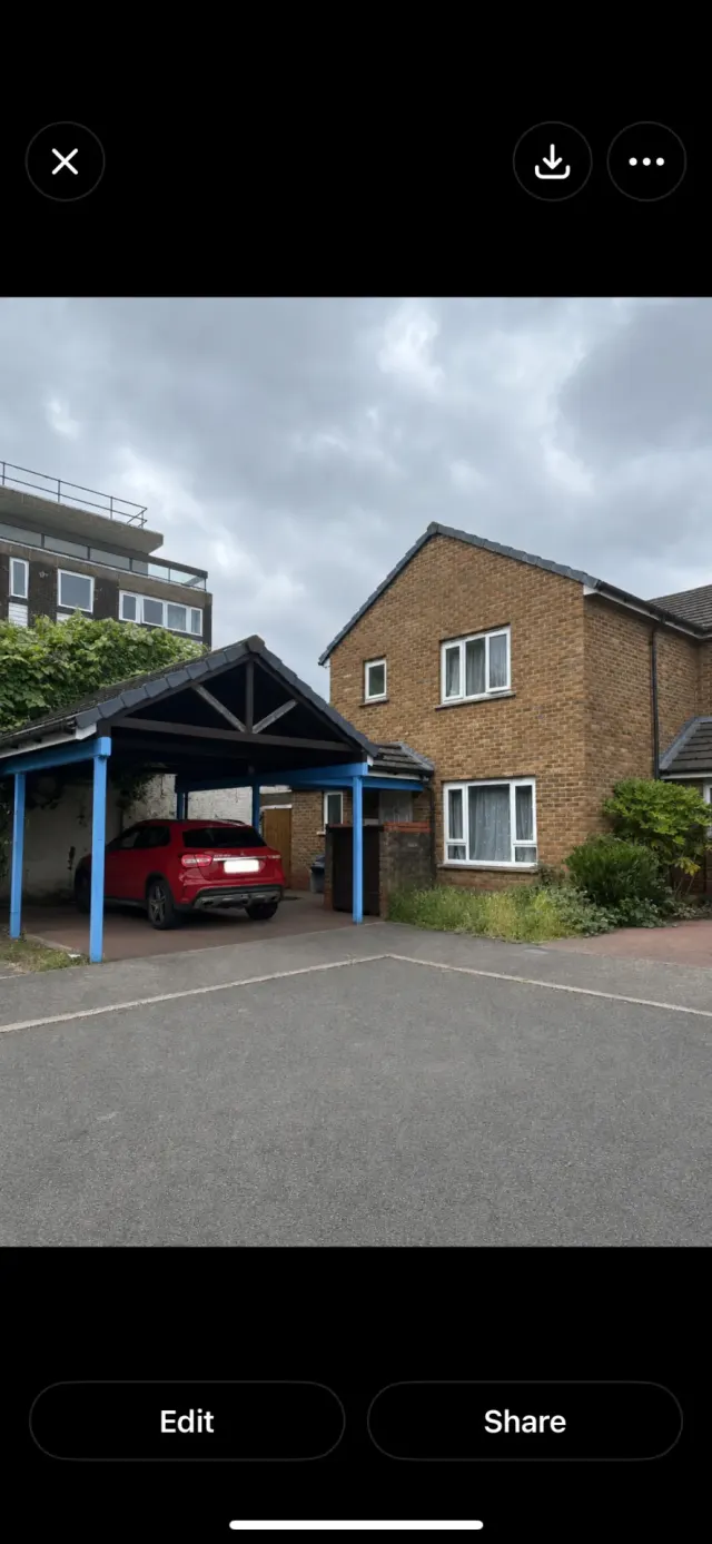
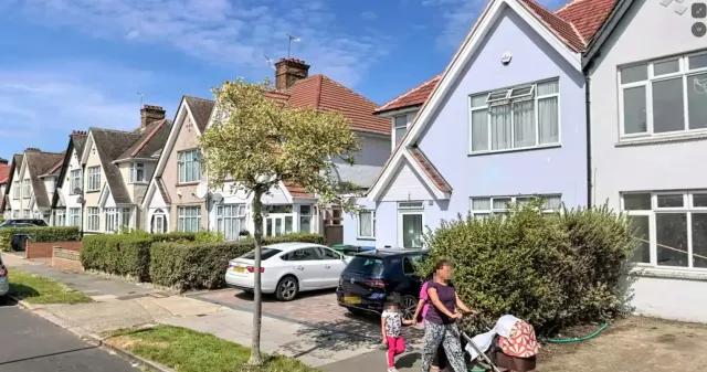
What is housing like in Ashford and who lives there?
Ashford's housing is mostly suburban family homes, and the wider picture explains the trade-offs. In Spelthorne, 68.1% of homes are owner-occupied and 17.9% are privately rented, while social renting accounts for 12.7%, below the England figure of 17.1%. Only 1.8% is council-owned; most social housing here is with housing associations.
A2Dominion South is by far the biggest landlord in the borough with close to 5,000 homes, followed by A2Dominion Housing Options, Metropolitan Housing Trust, Paragon Asra and Richmond Housing Partnership. Average weekly social rents in 2024/25 were £122 for a one bed, £145 for two and £163 for three.
The age profile is close to the national average, with a slightly larger share of 25 to 44 year olds and a good number of children, so this feels like a mixed town rather than one age group. Social housing is in demand: Spelthorne's register held 2,584 households at the end of March 2025, with 148 homes let through the council that year. That is why swapping is often the quicker route.
Council waiting list and lettings
Households on the register by the size of home they need.
That is roughly 17.5 households waiting for every social home let in a year. Mutual exchange doesn't use the waiting list: if you already have a council or housing association home, swapping with another tenant can be a quicker way to move to Ashford.
A register counts households who have applied, so it isn't a simple queue: some are already social tenants hoping to transfer, and people can be on more than one council's list.
Typical weekly social rents in the Spelthorne council area
| Size | Council | Housing association |
|---|---|---|
| Bedsit | £0 | £105 |
| 1 bed | £0 | £122 |
| 2 bed | £0 | £145 |
| 3 bed | £0 | £163 |
| 4 bed | £0 | £178 |
Social rent averages for 2024/25. Affordable rent homes cost more, typically 60 to 80% of market rent.
Biggest social landlords in the council area
- A2Dominion South Limited4,995 homes
- A2Dominion Housing Options Limited319 homes
- Metropolitan Housing Trust Limited311 homes
- Paragon Asra Housing Limited152 homes
- Richmond Housing Partnership Limited104 homes
- Clarion Housing Association Limited103 homes
- Transform Housing & Support68 homes
- Peabody Trust59 homes
What are the schools and family life like in Ashford?
Families are well served for primary schools. St Michael Primary and Clarendon Primary are both within a third of a mile of the town centre, with The Echelford Primary School and Ashford Primary School around half a mile out. Fordway Centre SSS is also nearby for specialist provision.
For older children, The Matthew Arnold School is just over a mile away, and St James Senior Boys School is closer still. Within a couple of miles you also have Space Studio West London, The Bishop Wand School and The Marjory Kinnon School, which broadens the choice more than you might expect for a town this size. As always, check catchment and admissions for the year you are moving.
Day to day, Ashford Recreation Ground is the main green space within easy reach, with Fordbridge Park and Echelforde Recreation Ground under a mile away. Ashford Library is right in the centre, and the Fordbridge Centre and Town Tree Hall run community activities close by.
Primary schools
- St Michael Primary Schoolnearby
- Clarendon Primary School0.3 mi
- Fordway Centre SSS0.5 mi
- The Echelford Primary School0.6 mi
- Ashford Primary School0.6 mi
Secondary schools
- StJamesseniorboysschool0.6 mi
- The Matthew Arnold School1.1 mi
- Space Studio West London2.2 mi
- The Bishop Wand School2.2 mi
- The Marjory Kinnon School2.2 mi
Parks
- Ashford Recreation Ground0.3 mi
- Garden Delights Services0.7 mi
- Bedfont Lakes (Clockhouse Lane) Parking0.7 mi
- Fordbridge Park0.7 mi
- Echelforde Recreation Ground0.8 mi
Libraries
- Ashford Librarynearby
- Stanwell Library and Room Hire1.5 mi
- School Library Service1.7 mi
- Bedfont Community Hub & Library1.8 mi
- Sunbury Library2 mi
What shops and everyday essentials are in Ashford?
Supermarkets
- Ashford Halal Market (halal meat)nearby
- Porto Madeira Supermarketnearby
- Desiee Stylesnearby
- Sainsbury's Localnearby
- Tesco Expressnearby
Pharmacies
- Boots Pharmacynearby
- Pyramid Pharmacy + Travel & Weightloss clinicnearby
- NHS Pharmacynearby
- Breakspearnearby
- Superdrug Pharmacy0.3 mi
Hospitals
- Foot Cornernearby
- Studholme Medical Centrenearby
- Fordbridge Medical Centrenearby
- Stanwell Road Surgery0.5 mi
- Ashford Hospital0.9 mi
Shopping centres
- Sunglass Hut2 mi
- Sunbury Cross Park & Shop2 mi
- Sunbury Cross Shopping Centre2 mi
- The Elmsleigh Centre2.1 mi
- Manor Retail Park2.2 mi
How do you get around Ashford?
Ashford station is about a quarter of a mile from the middle of town, with services towards London and out through Surrey. Staines station is under two miles away if you want more options, and Upper Halliford and Sunbury are both within three miles. Heathrow Terminal 4 station sits around two miles away, which is a genuine plus if you or a family member works at the airport.
Buses run from stops on Dudley Road, Station Crescent and by the railway station, linking Ashford with neighbouring towns. Services are useful rather than constant, so it pays to check times for your own route before you commit.
On foot, the town centre is flat and compact. Shops, the library, pharmacies and the recreation ground are all within half a mile of the centre, which makes life easier if you do not drive. By car, you are close to the roads feeding Heathrow and the motorway network, though that traffic is also the price you pay at rush hour.
Train stations
- Ashford0.4 mi
- Staines1.8 mi
- Upper Halliford1.9 mi
- Heathrow Terminal 42 mi
- Sunbury2.2 mi
Bus stations
- Dudley Roadnearby
- Ashford Railway Station0.3 mi
- Ashford Railway Station0.4 mi
- Station Crescent0.5 mi
- Station Crescent0.5 mi
What is there to do in Ashford?
Ashford is a town for everyday things rather than big attractions, and it is honest about that. The recreation ground, Fordbridge Park and the green space around Bedfont Lakes give you somewhere to walk, run or take the children. Energie Fitness sits in the town centre, there is an outdoor gym at Hengrove Park, and a couple of smaller training studios within a mile or so.
For a drink, the Kings Head, Elle & Fee, The King's Fairway and the Freeman Arms are all within half a mile, so a local is never far. Ashford Library is a short walk from most of the town centre.
When you want more, Staines is the place you go. The Elmsleigh Centre and a Vue cinema are around two miles away, with Sunbury Cross Shopping Centre and Manor Retail Park a similar distance, and Cineworld at Feltham a little further. Between them they cover shopping, films and chain restaurants without a trip into London.
Gyms
- Energie Fitness Ashfordnearby
- Hengrove Park Outdoor Gym0.9 mi
- BUILT Training1.2 mi
- Lifestyle Fitness Matthew Arnold1.2 mi
- The Pole Hub Staines1.2 mi
Cinemas
- Vue Cinema Staines2.2 mi
- Cineworld - Feltham2.6 mi
Pubs and bars
- Kings Headnearby
- Elle & Fee0.3 mi
- The King's Fairway0.4 mi
- Freeman Arms0.5 mi
- The District Arms0.7 mi
Nightlife
- Soul Disco1 mi
- Blush Lounge by Plaza Premium Group1.8 mi
- Qatar Airways' lounge1.9 mi
- Malaysia Airlines Golden Lounge1.9 mi
- Falcon Gold1.9 mi
Community centres
- Fordbridge Centrenearby
- Town Tree Hall0.3 mi
- The Salvation Army - Staines0.6 mi
- Ashford (Middlesex) Community Association0.8 mi
- A2Dominion | Stanwell Rose Community Centre1.1 mi
What is work and the local economy like in Ashford?
Spelthorne is a working borough. Across the council area, 61.8% of adults are in work, above the England figure of 57.4%, and unemployment sits at 3.6%, close to the national 3.5%. Benefit claimant figures follow the same pattern, at 3.6% of working-age people against 4% for England.
The obvious reason is Heathrow. With Terminal 4 around two miles away and good road and rail links to it, airport and airport-related work, from ground handling to logistics, hotels and catering, shapes a lot of local employment. Staines, two miles off, adds office and retail jobs.
Locally in Ashford itself, the jobs are the ones you would expect in a town centre: shops, supermarkets, pharmacies, care and medical work at the surgeries and Ashford Hospital, and schools. Commuting into London by train is realistic from Ashford station if your work is in the capital. Shift workers in particular tend to find the location here does a lot of the heavy lifting.
Figures are for the Spelthorne council area, Census 2021 and ONS claimant count.
How safe is Ashford?
Like every town centre, Ashford has police incidents logged each month. In July 2026 there were 196 within about a mile of the centre, made up of:
- Anti-social behaviour reports29
- Vehicle crime11
- Shoplifting35
- Other theft11
- Criminal damage14
- Burglary3
Source: data.police.uk street-level crime. Counts cover a fixed one-mile radius around the centre, so busy high streets and stations always record far more than the residential streets around them, and most incidents are minor. Compare like with like: a similar-sized town centre, not a village.
Is Ashford a good place for council and housing association tenants?
Right now: 2 homes to swap within 15 miles of Ashford.
If Ashford sounds like it would suit you, the next step is simple. Put your own home on Mutual Home Exchange, add clear photos and an honest description, and set Ashford or the TW15 area as somewhere you want to move to. Swaps happen when the right pair of people find each other, so being visible matters more than anything else.
Be specific in your listing about what you have: number of bedrooms, floor level, garden or not, parking, and your landlord. Say why you are moving too. Tenants here often care about being near the station, the schools or Heathrow shifts, so mention those things if your own home offers something similar.
It is worth widening your search to nearby areas like Staines, Sunbury and Stanwell as well, since they share many of the same links and landlords. Listing is free, and both landlords have to agree any exchange before it goes ahead, so take your time and view before you decide.
Good luck with the move.
ad
Tell me when a home appears near Ashford
One email, the first time a council or housing association home is listed within your chosen distance. No newsletter, no spam.
Live in Ashford? Add a photo
Tenants' own photos help other people picture the place. Approved photos are credited to you. Submit a photo.
Nearby place guides
Thinking of moving a little further? Compare homes to swap, rents and local landlords in places near Ashford.
All place guides in Surrey → · All place guides in the South East → · All regions →