What it's like to live in Bexleyheath
Bexleyheath is a busy suburban town of around 15,600 people in the London Borough of Bexley, on the south-east edge of the capital. It has a proper town centre with a shopping mall and cinema, plus quiet residential streets of houses with gardens. It suits families and anyone who wants London on hand without living in the thick of it, with Bursted Woods and King George's Field close by.
"I'd move here" adds Bexleyheath to the areas on your listing, so homes here are matched to you first.
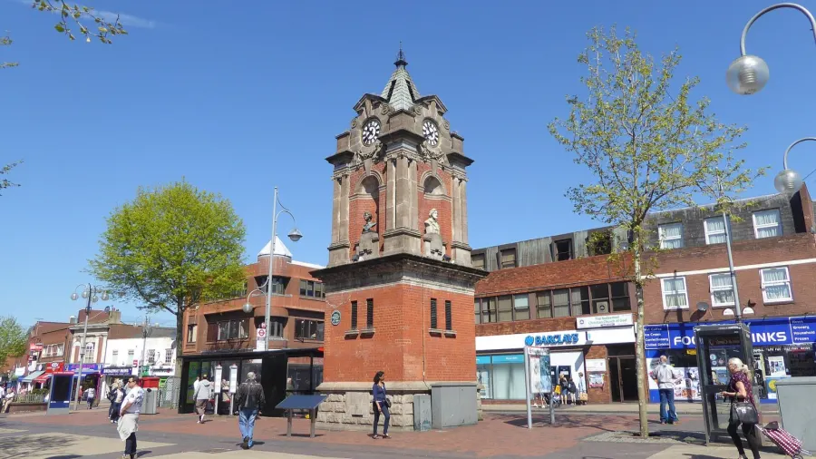
Bexleyheath sits in the London Borough of Bexley, in the outer south-east of London, between Welling to the west and Barnehurst and Erith to the east. Dartford and the Kent border are a short hop away, and central London is a direct train ride north-west. It is firmly London, but it looks and feels like a Kent commuter town.
People move here for the mix. You get a real town centre with a shopping mall, cinema and gyms, a station on your doorstep and a choice of well-regarded secondary schools, but the housing is suburban rather than high-density. For tenants coming from inner London, the trade is usually more space, more green and a slower pace, without losing the commute.
It is also a handy base for the wider area. Erith and District Hospital is within a mile and a half, the A2 and A207 put the Kent coast and the M25 in reach by car, and neighbouring Bexley towns are close enough that work, family and friends across the borough stay easy to reach.
Swapping to Bexleyheath: key facts
Can I swap my council or housing association home to Bexleyheath?
Yes, if you are already a council or housing association tenant. Mutual exchange means swapping homes with another social tenant, so it does not depend on the council waiting list: you need a tenant in or near Bexleyheath who wants your area, and both landlords must agree. Landlords have 42 days to decide and can only refuse on set legal grounds.
How long is the council housing waiting list in Bexleyheath?
1,640 households were on the Bexley housing register on 31 March 2025, up 11% on a year earlier. 371 social homes were let through the council in 2024 to 2025, roughly 4.4 households for every home let. Source: Local Authority Housing Statistics, Ministry of Housing, Communities and Local Government.
How much is social rent in Bexleyheath?
Average weekly social rents in the Bexley council area in 2024/25: 1 bed £0 council, £111 housing association; 2 bed £0 council, £130 housing association; 3 bed £159 council, £156 housing association. Affordable rent homes cost more, typically 60 to 80% of market rent. Source: Regulator of Social Housing.
How much social housing is there in Bexleyheath and who owns it?
14.7% of homes in the Bexley council area are social housing (council 2.6%, housing association 12.1%), against 17.1% across England, according to the 2021 Census. The biggest social landlords there are London & Quadrant Housing Trust (5,044 homes), Orbit Housing Association Limited (3,965 homes) and Peabody Trust (2,859 homes).
How Busy Is The Swap Market In Bexleyheath?
Figures as of 1 November 2026, updated every night. The waiting list figure is from 2024 to 2025 government data.
Which homes are available to swap near Bexleyheath?
Homes are shown near their address, not on it. Contains OS data © Crown copyright and database right. Source: Office for National Statistics, Open Government Licence.
No homes listed within 2 miles at the moment. New homes are listed every week: see homes across London, use the alert form below, or list your own home so tenants here can find you.
What is housing like in Bexleyheath and who lives there?
Bexley is an owner-occupier borough: 68.6% of homes are owned outright or with a mortgage, 15.3% are privately rented and 14.7% are social rented, slightly below the England figure of 17.1%. Only 2.6% is council stock, with 12.1% held by housing associations, so most social tenants here have a housing association landlord.
The largest social landlords across the borough are London & Quadrant Housing Trust with just over 5,000 homes, Orbit Housing Association with nearly 4,000, Peabody Trust with around 2,860, and smaller holdings from Hyde Housing Association and Moat Homes.
Average weekly social rents in the Bexley area for 2024/25 were about £111 for a one-bed, £130 for a two-bed and £156 for a three-bed. The age profile is close to the national picture, with slightly more children and slightly fewer over-65s. For context on demand, 1,640 households were on the council's housing register at 31 March 2025 and 371 social homes were let through the council in 2024-25 — a register is not a simple queue, which is why mutual exchange is worth pursuing.
Who owns the homes
Share of homes in the Bexley council area, Census 2021.
Ages
Share of people in each age group, Census 2021.
Council waiting list and lettings
Households on the register by the size of home they need.
That is roughly 4.4 households waiting for every social home let in a year. Mutual exchange doesn't use the waiting list: if you already have a council or housing association home, swapping with another tenant can be a quicker way to move to Bexleyheath.
A register counts households who have applied, so it isn't a simple queue: some are already social tenants hoping to transfer, and people can be on more than one council's list.
Typical weekly social rents in the Bexley council area
Social rent averages for 2024/25. Affordable rent homes cost more, typically 60 to 80% of market rent.
Biggest social landlords in the council area
- London & Quadrant Housing Trust5,044 homes
- Orbit Housing Association Limited3,965 homes
- Peabody Trust2,859 homes
- Hyde Housing Association Limited644 homes
- Moat Homes Limited625 homes
- Hexagon Housing Association Limited454 homes
- Orbit Group Limited327 homes
- Penge Churches Housing Association Limited143 homes
What is it like to live in Bexleyheath?
Day to day, the Broadway is the heart of it. The Broadway Shopping Centre sits a short walk from most of the town, and for food shopping there's an Asda, a Sainsbury's, a Lidl, a Co-op and a Londis all within a mile or so. Pharmacies are easy to find, with Praise, Broadway and Crooklog among the nearest.
Step off the main roads and it calms down quickly. Streets are mainly low-rise, with front gardens and parked cars. King George's Field, Russell Park, Bursted Woods, The Warren and Stevens Park give you five green spaces inside a mile and a half, so most homes have somewhere to walk the dog or let children run. Libraryplus Central Library is close in, with Welling, Bexley Village and Upper Belvedere community libraries a little further out.
What are the schools and family life like in Bexleyheath?
Families are well served for schools. Upland Primary School and St Thomas More Catholic Primary School are both around a quarter of a mile away, with Pelham Primary School and Brampton Primary Academy within a mile. At secondary level, Townley Grammar School is just under a mile, with St Columba's Catholic Boys' School and St Catherine's Catholic School about a mile out, plus Lift Bexleyheath and the Learning & Enterprise College Bexley for alternative and post-16 study. Always check current admissions and catchments before you commit to a swap.
The wider borough skews young: 20.5% of Bexley residents are under 16, above the England figure of 18.6%. You notice it in the parks and at the school gates.
For children outside school hours, King George's Field and Russell Park are the handiest open spaces, with Bursted Woods for proper tree cover. Bexleyheath Scout Group, Dandon Youth and Community Centre, Parkside Community Centre and All Saints Church Hall host local activities, and Libraryplus Central Library is the usual stop for free indoor time.
Primary schools
- Upland Primary Schoolnearby
- St Thomas More Catholic Primary Schoolnearby
- art K Art school0.3 mi
- Pelham Primary School0.5 mi
- Brampton Primary Academy0.6 mi
Secondary schools
- Lift Bexleyheathnearby
- Learning & Enterprise College Bexley0.6 mi
- Townley Grammar School0.9 mi
- St Columba's Catholic Boys' School1 mi
- St Catherine's Catholic School1 mi
Parks
- King George's Field0.3 mi
- Russell Park0.4 mi
- Bursted Woods0.7 mi
- The Warren0.9 mi
- Stevens Park1 mi
Libraries
- Libraryplus Central Library0.5 mi
- Upper Belvedere Community Library1.4 mi
- Bexley Village Community Library1.5 mi
- Welling Library1.5 mi
What shops and everyday essentials are in Bexleyheath?
Supermarkets
- The Co-operative Food0.3 mi
- Asda0.4 mi
- Sainsbury's0.6 mi
- Lidl0.7 mi
- Londis0.7 mi
Pharmacies
- Praise Pharmacy0.3 mi
- Broadway Pharmacy0.4 mi
- Crooklog Pharmacy0.5 mi
- Day Lewis Pharmacy0.7 mi
- Pharmacy Hut0.8 mi
Hospitals
- Erith and District Hospital1.5 mi
Shopping centres
- Broadway Shopping Centre0.6 mi
How do you get around Bexleyheath?
Bexleyheath station is about a third of a mile from the town centre, on the line running into London Bridge, Charing Cross and Cannon Street via Lewisham. Barnehurst station is under a mile away and gives a second option if you live on the eastern side. Trains are the main reason a lot of people choose this part of Bexley, and you can live here comfortably without a car.
Buses run through the Broadway and link Bexleyheath with Welling, Erith, Sidcup, Woolwich and Dartford, which matters if your work or school run doesn't follow the rail line. The town centre is a natural interchange, so most journeys within the borough start there.
On foot, the centre is flat and compact: shops, library, cinema and station are all within roughly half a mile of each other, and the residential streets around them are walkable. Drivers have the A2 and A207 nearby for Kent, the Blackwall Tunnel and the M25. Parking is easier than inner London, though the centre gets busy on Saturdays.
Train stations
- Bexleyheath0.3 mi
- Barnehurst0.9 mi
What is there to do in Bexleyheath?
For a town this size, there's plenty. Cineworld is under a mile from the centre, and the Broadway Shopping Centre covers most high street shopping without a trip into London. If you train, The Gym and Better Gym Bexleyheath are both around half a mile from the middle of town, with Novo Gym further out.
Pubs are a strength. The William Camden, The Kentish Belle, The Yacht, The Volunteer and Long Haul are all within a short walk of the centre, so there's a range from traditional to micropub. Pure Lounge Club is the main late-night option locally; for anything bigger, the train into town does the job.
Green space is the other draw. Bursted Woods is the one to know for a proper walk among trees, while The Warren and Stevens Park give you more open ground a mile or so out. King George's Field and Russell Park are closer in for a quick hour. Bexley Football Club and the local community centres run grassroots sport and clubs.
Gyms
- The Gym0.5 mi
- Better Gym Bexleyheath0.5 mi
- Novo Gym1.4 mi
Cinemas
- Cineworld0.7 mi
Pubs and bars
- Long Haul0.3 mi
- William Camden0.3 mi
- The Kentish Belle0.3 mi
- The Yacht0.3 mi
- The Volunteer0.3 mi
Nightlife
- Pure Lounge Club0.4 mi
Community centres
- Bexleyheath Scout Group0.4 mi
- Dandon Youth and Community Centre0.6 mi
- Bexley Football Club1.4 mi
- Parkside Community Centre1.4 mi
- All Saints Church Hall1.4 mi
What is work and the local economy like in Bexleyheath?
Figures here are for the Bexley council area rather than Bexleyheath alone, but they paint a steady picture. Around 60.2% of adults are in work, a little above the England average of 57.4%, and unemployment sits at 3.8% against 3.5% nationally. Benefit claimants related to unemployment were 3.4% of working-age residents in August 2026, below the England figure of 4%.
In practice, a lot of Bexley residents commute. The direct trains into London Bridge, Charing Cross and Cannon Street make central and south-east London jobs realistic, and Canary Wharf is reachable via Lewisham.
Closer to home, work is concentrated in retail and services around the Broadway and the shopping centre, health and care including Erith and District Hospital, and schools and colleges across the borough. Supermarkets, gyms, the cinema and pubs are all local employers too. It's a borough where plenty of people work locally and plenty travel, so a swap here doesn't tie you to one commute.
Figures are for the Bexley council area, Census 2021 and ONS claimant count.
How safe is Bexleyheath?
Like every town centre, Bexleyheath has police incidents logged each month. In August 2026 there were 401 within about a mile of the centre, made up of:
Source: data.police.uk street-level crime. Counts cover a fixed one-mile radius around the centre, so busy high streets and stations always record far more than the residential streets around them, and most incidents are minor. Compare like with like: a similar-sized town centre, not a village.
Is Bexleyheath a good place for social housing tenants?
If Bexleyheath looks like the right fit, the practical step is to get your own home listed properly. Clear photos, honest room sizes, your landlord's name and a straight description of what the property is and isn't will get you far more genuine replies than a rushed advert.
Then set Bexleyheath, or the DA7 postcode district, as a desired area. You can add nearby places too — Barnehurst, Welling and the rest of the borough are all close — which widens your options without moving you far from the schools and station you're aiming for.
Before you agree anything, visit at different times of day, walk from the property to the station and the nearest school, and check your landlord's mutual exchange rules. Both landlords have to approve a swap, so start those conversations early. Keep your listing up to date and reply to messages promptly: matches often come from people you contact first rather than people who find you.
Tell me when a home appears near Bexleyheath
One email, the first time a council or housing association home is listed within your chosen distance. No newsletter, no spam.
Live in Bexleyheath? Add a photo
Tenants' own photos help other people picture the place. Approved photos are credited to you. Submit a photo.
Nearby place guides
Thinking of moving a little further? Compare homes to swap, rents and local landlords in places near Bexleyheath.
On X: Homes Near Bexleyheath
Home to swap: 2-bed flat in London. Looking to move to Biggin hill, Gravesend and more.
#London #BigginHill #ClarionHousingAssociation