What it's like to live in Storrington
Storrington is a good-sized village in the Horsham district of West Sussex, with a proper village centre rather than just a row of shops. It suits people who want quiet surroundings, familiar faces and space for children, and who don't mind a slower pace. A Waitrose, a library and a scatter of country pubs sit within a short stroll of the middle.
"I'd move here" adds Storrington to the areas on your listing, so homes here are matched to you first.
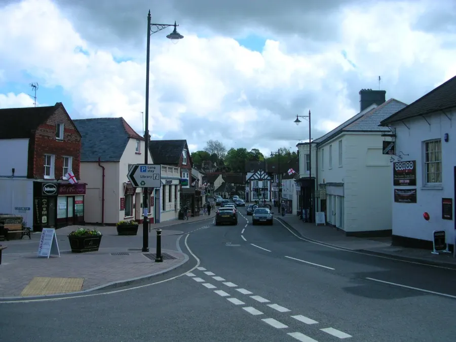
Storrington lies in the Horsham district of West Sussex, in the South East of England, with the RH20 postcode. It is a village rather than a town, set among smaller settlements like Thakeham, Sullington, Washington and West Chiltington, and it looks to Horsham itself as the main centre of the district.
People move here for the countryside setting and for a village that still has its own shops, library, bus station and schools, rather than relying entirely on somewhere bigger. For tenants used to a busy estate or a town centre flat, the change of pace is the main draw.
It is worth being clear-eyed about it. Storrington is in a part of West Sussex where owner occupation dominates, so social housing is thinner on the ground than in many towns. That makes a mutual exchange a realistic way in, and it also means it pays to be patient and flexible about the exact street. If you want green surroundings and a village you can walk across, it is a strong candidate.
Swapping to Storrington: key facts
Can I swap my council or housing association home to Storrington?
Yes, if you are already a council or housing association tenant. Mutual exchange means swapping homes with another social tenant, so it does not depend on the council waiting list: you need a tenant in or near Storrington who wants your area, and both landlords must agree. Landlords have 42 days to decide and can only refuse on set legal grounds.
How long is the council housing waiting list in Storrington?
716 households were on the Horsham housing register on 31 March 2025, down 5% on a year earlier. 276 social homes were let through the council in 2024 to 2025, roughly 2.6 households for every home let. Source: Local Authority Housing Statistics, Ministry of Housing, Communities and Local Government.
How much is social rent in Storrington?
Average weekly social rents in the Horsham council area in 2024/25: 1 bed £0 council, £115 housing association; 2 bed £0 council, £135 housing association; 3 bed £0 council, £155 housing association. Affordable rent homes cost more, typically 60 to 80% of market rent. Source: Regulator of Social Housing.
How much social housing is there in Storrington and who owns it?
11.5% of homes in the Horsham council area are social housing (council 1.2%, housing association 10.2%), against 17.1% across England, according to the 2021 Census. The biggest social landlords there are Saxon Weald (4,799 homes), Southern Housing (1,176 homes) and Moat Homes Limited (457 homes).
How Busy Is The Swap Market In Storrington?
Figures as of 21 October 2026, updated every night. The waiting list figure is from 2024 to 2025 government data.
Which homes are available to swap near Storrington?
Homes are shown near their address, not on it. Contains OS data © Crown copyright and database right. Source: Office for National Statistics, Open Government Licence.
No homes listed within 5 miles at the moment. New homes are listed every week: see homes across West Sussex, use the alert form below, or list your own home so tenants here can find you.
What is housing like in Storrington and who lives there?
Housing in the Horsham district is dominated by owner occupiers, who make up 72.3% of households. Social renting accounts for 11.5%, below the England figure of 17.1%, and most of that is housing association rather than council stock, at 10.2% against just 1.2%. Private renting takes 14.5%.
Saxon Weald is comfortably the largest social landlord locally with around 4,799 homes, followed by Southern Housing with 1,176, then Moat Homes, Clarion and Hyde, each with a few hundred. Average weekly social rents across the district in 2024/25 were about £115 for a one bed, £135 for two beds and £155 for three.
The age profile leans older than England as a whole: 22.8% of residents in the council area are 65 or over, compared with 18.4% nationally, while the 25 to 44 group is smaller. Storrington's village setting tends to reflect that. For context, 716 households were on the Horsham council housing register at March 2025 and 276 social homes were let through the council that year, which is one reason an exchange is worth exploring.
Council waiting list and lettings
Households on the register by the size of home they need.
That is roughly 2.6 households waiting for every social home let in a year. Mutual exchange doesn't use the waiting list: if you already have a council or housing association home, swapping with another tenant can be a quicker way to move to Storrington.
A register counts households who have applied, so it isn't a simple queue: some are already social tenants hoping to transfer, and people can be on more than one council's list.
Typical weekly social rents in the Horsham council area
| Size | Council | Housing association |
|---|---|---|
| Bedsit | £0 | £98 |
| 1 bed | £0 | £115 |
| 2 bed | £0 | £135 |
| 3 bed | £0 | £155 |
| 4 bed | £0 | £172 |
Social rent averages for 2024/25. Affordable rent homes cost more, typically 60 to 80% of market rent.
Biggest social landlords in the council area
- Saxon Weald4,799 homes
- Southern Housing1,176 homes
- Moat Homes Limited457 homes
- Clarion Housing Association Limited436 homes
- Hyde Housing Association Limited431 homes
- Raven Housing Trust Limited159 homes
- Stonewater Limited118 homes
- Orbit Housing Association Limited115 homes
What is it like to live in Storrington?
Day to day, most of what you need is close together. The supermarket, a Nisa Local, Lloyds Pharmacy and Boots are all within a few minutes of the centre, and Storrington Library is right there too. That makes a big difference if you'd rather not drive for every loaf of bread.
Green space is easy to reach. Sullington Parish Hall Park is about half a mile out, with Hamper's Green and Millford Grange Country Park a little over a mile away. Storrington Village Hall and the Ravenscroft Guide & Community Centre keep village life ticking along, and there are more halls in Thakeham, Washington and West Chiltington nearby. It is a settled, countryside sort of place, and that is both its charm and its limit.
What are the schools and family life like in Storrington?
Families are well served for schools. Storrington Primary School is about a third of a mile from the centre, with Thakeham Primary School under a mile away. A little further out you'll find St Mary's C.E. Primary School at around two miles, West Chiltington Community Primary School and Ashington CofE Primary School both under three.
For older children, Steyning Grammar School's Rock Road Campus is less than a mile away, which is a short journey by village standards. Windlesham House School sits about two and a half miles out. As always, check current admissions and catchment details with West Sussex County Council before you plan around a particular school.
Outside school hours, Storrington Library is on the doorstep, and there are three parks within a mile and a half: Sullington Parish Hall Park, Hamper's Green and Millford Grange Country Park. Village halls in Storrington, Thakeham, Washington and West Chiltington, plus the Ravenscroft Guide & Community Centre, tend to be where clubs and children's groups meet. In the wider Horsham area, 17.7% of residents are under 16, slightly below the England figure.
Primary schools
- Storrington Primary School0.3 mi
- Thakeham Primary School0.9 mi
- St Mary's C.E. Primary School2.2 mi
- West Chiltington Community Primary School2.6 mi
- Ashington CofE Primary School2.7 mi
Secondary schools
- Steyning Grammar School (Rock Road Campus)0.9 mi
- Windlesham House School2.5 mi
Parks
- Sullington Parish Hall Park0.5 mi
- Hamper's Green1.3 mi
- Millford Grange Country Park1.4 mi
Libraries
- Storrington Librarynearby
What shops and everyday essentials are in Storrington?
Supermarkets
- Waitrosenearby
- Nisa Localnearby
Pharmacies
- Lloyds Pharmacynearby
- Bootsnearby
How do you get around Storrington?
Storrington has its own bus station, right in the middle of the village about a tenth of a mile from the shops. That is unusual for a village this size and it matters a great deal if you don't drive, since buses are the main public transport link to surrounding towns.
There is no railway station within three miles, so rail travel means getting to a station further afield, usually by bus or car first. If trains are part of your daily routine, check timetables and journey times carefully before you commit to a swap.
On foot, the centre works well. The library, both supermarkets, the pharmacies and The Moon pub are all within a few minutes' walk of each other, and the primary school is only about a third of a mile out. Further afield, country lanes connect the nearby villages, which is pleasant walking but not always well lit or pavemented.
A car gives you the most freedom here, particularly for evening trips, but plenty of day-to-day life can be done without one if you live near the centre.
Bus stations
- Storrington Bus Stationnearby
What is there to do in Storrington?
This is village leisure rather than city nightlife, and it helps to know that going in. The Moon sits in the centre of Storrington, with The Crown Inn under a mile out and The Five Bells and The White Lion Inn within a couple of miles. West Sussex Golf Club is about two miles away.
Green space is the real pull. Millford Grange Country Park, roughly a mile and a half out, is the biggest of the three nearby parks, with Hamper's Green and the smaller Sullington Parish Hall Park closer in. The surrounding lanes and countryside are made for walking and cycling.
For everything else, Storrington Library is a hub as well as a place to borrow books, and the village hall and community centre host the sort of local groups, fairs and classes that village life runs on. If you want cinemas, big shopping or a wide choice of restaurants, you will be travelling to a larger town, so factor that into your plans.
Pubs and bars
- The Moonnearby
- The Crown Inn0.8 mi
- The Five Bells1.7 mi
- West Sussex Golf Club1.9 mi
- The White Lion Inn2.3 mi
Community centres
- Ravenscroft Guide & Community Centrenearby
- Storrington Village Hallnearby
- Thakeham Village Hall1.9 mi
- Washington Village Memorial Hall2.2 mi
- West Chiltington Village Hall2.3 mi
What is work and the local economy like in Storrington?
The figures here cover the wider Horsham council area rather than Storrington alone, but they paint a healthy picture. Just under 60% of adults are in work, a shade above the England average of 57.4%, and unemployment sits at 2.4% against 3.5% nationally.
That pattern holds in more recent data too. In September 2026, 2% of 16 to 64 year olds in the Horsham area were claiming unemployment-related benefits, half the England figure of 4%. In short, this is a district where most working-age people are in a job.
What that doesn't tell you is where those jobs are. Storrington itself is a village, so local work tends to mean shops, schools, care, trades and services, while many residents travel to Horsham or other towns. If you have a job lined up or are job hunting, work out the commute before you accept a swap, especially if you rely on buses. A short trip on paper can be a long one in practice from a rural village.
Figures are for the Horsham council area, Census 2021 and ONS claimant count.
How safe is Storrington?
Like every town centre, Storrington has police incidents logged each month. In August 2026 there were 31 within about a mile of the centre, made up of:
- Anti-social behaviour reports11
- Vehicle crime2
- Other theft1
- Criminal damage2
- Burglary3
- Drug offences1
Source: data.police.uk street-level crime. Counts cover a fixed one-mile radius around the centre, so busy high streets and stations always record far more than the residential streets around them, and most incidents are minor. Compare like with like: a similar-sized town centre, not a village.
Is Storrington a good place for social housing tenants?
If Storrington looks like the right fit, the practical step is to put your own home on Mutual Home Exchange and add Storrington, or the wider RH20 area, to your list of desired areas. Listings are free for council and housing association tenants, and a clear, honest advert with good photos gets far more interest than a rushed one.
Because social housing is a smaller slice of the market in this part of West Sussex, it is worth widening your search to the nearby villages as well, such as Thakeham, Washington, West Chiltington and Ashington, all within a few miles. Keeping an open mind on the exact street usually gets you a match faster.
Before you agree anything, visit at the times you'd normally travel, check the bus options for your routine, and talk to your landlord about permission and the condition of both homes. Exchanges need sign-off on each side. Take your time, ask plenty of questions, and only move when the match genuinely works for your household.
Tell me when a home appears near Storrington
One email, the first time a council or housing association home is listed within your chosen distance. No newsletter, no spam.
Live in Storrington? Add a photo
Tenants' own photos help other people picture the place. Approved photos are credited to you. Submit a photo.
Nearby place guides
Thinking of moving a little further? Compare homes to swap, rents and local landlords in places near Storrington.
All place guides in West Sussex → · All place guides in the South East → · All regions →