What it's like to live in Tenterden
Tenterden is a small Kentish market town of around 8,200 people in the Ashford borough, with a broad tree-lined main street and open countryside on every side. It suits people who want a quieter, settled pace without being cut off from shops and services. Two supermarkets, a library and a town-centre hospital site are all close at hand.
"I'd move here" adds Tenterden to the areas on your listing, so homes here are matched to you first.
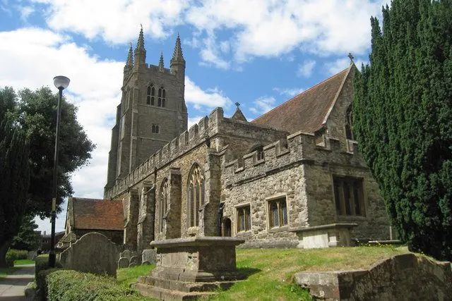
Tenterden sits in the Weald of Kent, in the south of the Ashford borough and close to the East Sussex border. Ashford is the main town for bigger shopping and services, with Rolvenden, Wittersham and High Halden among the villages scattered around it.
People move here for the scale of the place. With a population of roughly 8,200, it is a town rather than a village, but a small one, and it keeps a working high street with everyday shops and two supermarkets rather than relying entirely on a larger neighbour.
For tenants, the draw is usually a combination of countryside surroundings and a decent spread of local services: schools from infant through to sixth form, a library, pharmacies and a hospital site all within the town or a short distance of it. Social housing is less common here than in England as a whole, which makes a mutual exchange a realistic route in. It is worth being honest that a smaller town means fewer homes changing hands, so patience helps.
Swapping to Tenterden: key facts
Can I swap my council or housing association home to Tenterden?
Yes, if you are already a council or housing association tenant. Mutual exchange means swapping homes with another social tenant, so it does not depend on the council waiting list: you need a tenant in or near Tenterden who wants your area, and both landlords must agree. Landlords have 42 days to decide and can only refuse on set legal grounds. In 2024 to 2025, 75 council homes in Ashford changed tenants by mutual exchange.
How long is the council housing waiting list in Tenterden?
1,478 households were on the Ashford housing register on 31 March 2025, up 1% on a year earlier. 355 social homes were let through the council in 2024 to 2025, roughly 4.2 households for every home let. Source: Local Authority Housing Statistics, Ministry of Housing, Communities and Local Government.
How much is social rent in Tenterden?
Average weekly social rents in the Ashford council area in 2024/25: 1 bed £96 council, £107 housing association; 2 bed £109 council, £123 housing association; 3 bed £121 council, £137 housing association. Affordable rent homes cost more, typically 60 to 80% of market rent. Source: Regulator of Social Housing.
How much social housing is there in Tenterden and who owns it?
14% of homes in the Ashford council area are social housing (council 8.9%, housing association 5.1%), against 17.1% across England, according to the 2021 Census. The biggest social landlords there are Ashford Borough Council (5,157 homes), Moat Homes Limited (653 homes) and West Kent Housing Association (600 homes).
How Busy Is The Swap Market In Tenterden?
Figures as of 21 October 2026, updated every night. The waiting list figure is from 2024 to 2025 government data.
Which homes are available to swap near Tenterden?
Homes are shown near their address, not on it. Contains OS data © Crown copyright and database right. Source: Office for National Statistics, Open Government Licence.
No homes listed within 5 miles at the moment. New homes are listed every week: see homes across Kent, use the alert form below, or list your own home so tenants here can find you.
What is housing like in Tenterden and who lives there?
Across the Ashford borough, 14% of homes are socially rented, below the England figure of 17.1%. Council homes make up 8.9% and housing association homes 5.1%, while 66.4% are owner-occupied and 17.7% privately rented. Tenterden is a town where owning is the norm, so social homes are relatively scarce and tend to be held onto.
Ashford Borough Council is by far the biggest social landlord in the area with 5,157 homes, followed by Moat Homes Limited (653), West Kent Housing Association (600), Southern Housing (532) and Clarion Housing Association Limited (406). Average weekly social rents in 2024/25 were about £99 for one bed, £115 for two beds and £125 for three.
The borough's age profile is slightly older than England's, with 19.6% aged 65 and over and 26.5% aged 45 to 64. At the end of March 2025, 1,478 households were on Ashford's housing register, and 355 social homes were let through the council during the year.
Council waiting list and lettings
Households on the register by the size of home they need.
That is roughly 4.2 households waiting for every social home let in a year. Mutual exchange doesn't use the waiting list: if you already have a council or housing association home, swapping with another tenant can be a quicker way to move to Tenterden.
A register counts households who have applied, so it isn't a simple queue: some are already social tenants hoping to transfer, and people can be on more than one council's list.
Typical weekly social rents in the Ashford council area
| Size | Council | Housing association |
|---|---|---|
| Bedsit | £72 | £0 |
| 1 bed | £96 | £107 |
| 2 bed | £109 | £123 |
| 3 bed | £121 | £137 |
| 4 bed | £124 | £149 |
Social rent averages for 2024/25. Affordable rent homes cost more, typically 60 to 80% of market rent.
Biggest social landlords in the council area
- Ashford Borough Council5,157 homes
- Moat Homes Limited653 homes
- West Kent Housing Association600 homes
- Southern Housing532 homes
- Clarion Housing Association Limited406 homes
- English Rural Housing Association Limited188 homes
- Accent Housing Limited179 homes
- Hyde Housing Association Limited168 homes
What is it like to live in Tenterden?
Day to day, life revolves around the High Street. Tesco and Waitrose are both within a couple of hundred metres of the centre, with a Costcutter further out towards the villages. Paydens and Boots cover prescriptions, and West View Hospital sits about half a mile away. Tenterden Library is right in the town.
The town itself is compact, so most errands can be done on foot if you live centrally. Formal parkland is thin on the ground here: the nearest listed park, Hookstead Green, is around 2.6 miles away, so green space tends to mean footpaths, verges and the surrounding farmland rather than a big municipal park. Rolvenden and High Halden are the nearest villages, each a few minutes by road.
What are the schools and family life like in Tenterden?
Families are well served for schools. Tenterden Infant School and Tenterden Church of England Junior School are both about 0.3 miles from the centre, with St Michael's Church of England Primary School 1.3 miles away. Rolvenden Primary School and High Halden Church of England Primary School, each under three miles out, give options in the nearby villages.
For older children, Homewood School & Sixth Form Centre is around 0.8 miles away and keeps teenagers in the town through to 18, which matters in a rural area where long bus journeys to sixth form are common. Little Acorns School and Greenfields School are also within three miles.
Everyday family life leans on the town centre: the library, the two supermarkets and short walking distances. Dedicated parks are limited, with Hookstead Green the nearest at 2.6 miles, so weekends often mean countryside walks or a drive out. Across the wider Ashford borough, 19.5% of residents are under 16, a little above the England figure.
Primary schools
- Tenterden Infant School0.3 mi
- Tenterden Church of England Junior School0.3 mi
- St Michael's Church of England Primary School1.3 mi
- Rolvenden Primary School2.6 mi
- High Halden Church of England Primary School2.7 mi
Secondary schools
- Homewood School & Sixth Form Centre0.8 mi
- Little Acorns School1.9 mi
- Greenfields School2.5 mi
Parks
- Hookstead Green2.6 mi
Libraries
- Tenterden Librarynearby
What shops and everyday essentials are in Tenterden?
Supermarkets
- Tesconearby
- Waitrosenearby
- Costcutter1.2 mi
Pharmacies
- Paydensnearby
- Boots0.3 mi
Hospitals
- West View Hospital0.5 mi
How do you get around Tenterden?
Tenterden is an easy town to walk around if you live near the centre. The High Street, library, supermarkets and pharmacies are all clustered within a few hundred metres, and the infant and junior schools are about a third of a mile out. Pavements and short distances make the school run on foot realistic for many families here.
Three stations sit within three miles: Tenterden Town just off the High Street, Rolvenden a little over a mile away and Wittersham Road around 2.9 miles out. Check timetables and destinations carefully before you rely on them for commuting, as services from small rural stations can be limited.
For longer trips, most people here use the road network towards Ashford and the surrounding villages. Bus details are not covered in the information we hold, so it is worth looking up current routes and frequencies for your exact street before deciding. If you do not drive, visit at the time of day you would actually be travelling.
Train stations
- Tenterden Townnearby
- Rolvenden1.1 mi
- Wittersham Road2.9 mi
What is there to do in Tenterden?
Tenterden's social life is centred on its High Street and its pubs. The Print House Inn and the Woolpack Hotel are both in the heart of town, with the Fat Ox about a mile out, The Crown around 1.2 miles and the Ewe and Lamb at 2.5 miles towards the villages. That gives a decent spread for a town of this size.
Tenterden Library is in the town itself and is a useful free resource, particularly for families and anyone working or studying from home. Rolvenden Village Hall, about 2.5 miles away, is the nearest community centre listed and the sort of place local groups tend to use.
Outdoor space is more countryside than park. Hookstead Green, 2.6 miles away, is the only park in our records within three miles, so expect footpaths, lanes and open Wealden farmland rather than playing fields on your doorstep. If outdoor space for children matters to you, check what is within walking distance of the specific address.
Pubs and bars
- The Print House Innnearby
- Woolpack Hotelnearby
- Fat Ox1 mi
- The Crown1.2 mi
- Ewe and Lamb2.5 mi
Community centres
- Rolvenden Village Hall2.5 mi
What is work and the local economy like in Tenterden?
The employment picture for the wider Ashford borough is healthy. Among adults, 59.6% are in work, above the England average of 57.4%, and unemployment stands at 2.9% against 3.5% nationally. Unemployment-related benefit claims in August 2026 were 2.9% of 16 to 64 year olds, compared with 4% across England.
In Tenterden itself, local jobs tend to come from the things that keep a small town running: shops and supermarkets on and around the High Street, the schools, health services including West View Hospital, and hospitality in the pubs and hotels. That means a reasonable supply of part-time and shift work, but a narrower range than a city.
Many people here travel to Ashford or further for work, so think about your commute before you commit. If you rely on public transport, check the journey to your workplace at the hours you would actually need it. Those numbers above cover the whole borough, not Tenterden alone.
Figures are for the Ashford council area, Census 2021 and ONS claimant count.
How safe is Tenterden?
Like every town centre, Tenterden has police incidents logged each month. In August 2026 there were 47 within about a mile of the centre, made up of:
- Anti-social behaviour reports11
- Shoplifting1
- Other theft4
- Criminal damage9
- Burglary2
- Public order1
Source: data.police.uk street-level crime. Counts cover a fixed one-mile radius around the centre, so busy high streets and stations always record far more than the residential streets around them, and most incidents are minor. Compare like with like: a similar-sized town centre, not a village.
Is Tenterden a good place for social housing tenants?
If Tenterden appeals, the practical next step is to put your own home on Mutual Home Exchange and add Tenterden to your list of desired areas. Swaps happen when the right match appears, and you cannot be matched if your home is not visible to other tenants looking to move.
Write your advert with the person on the other end in mind. Say what your home has, honestly: bedrooms, floor level, garden or outside space, heating, parking, and anything that needs work. Clear photos of every room make a real difference. Mention why you want Tenterden, whether that is schools, countryside or being near family.
In a small town with limited social housing, matches can take time, so it is worth adding nearby villages and parts of the wider Ashford borough as well. Keep your listing up to date, reply to messages promptly, and in 2024-25 some 75 Ashford council homes changed hands through mutual exchange, so it does happen.
Tell me when a home appears near Tenterden
One email, the first time a council or housing association home is listed within your chosen distance. No newsletter, no spam.
Live in Tenterden? Add a photo
Tenants' own photos help other people picture the place. Approved photos are credited to you. Submit a photo.
Nearby place guides
Thinking of moving a little further? Compare homes to swap, rents and local landlords in places near Tenterden.
All place guides in Kent → · All place guides in the South East → · All regions →