What it's like to live in Haslingden
Haslingden is a stone-built former mill town in the Rossendale valley, Lancashire, with about 16,849 people and moorland rising behind the rooftops. It feels settled and down-to-earth rather than smart, and it suits families and anyone who wants a real town centre without big-city noise. The hills and a well-used library close to the middle are the standout pluses.
"I'd move here" adds Haslingden to the areas on your listing, so homes here are matched to you first.
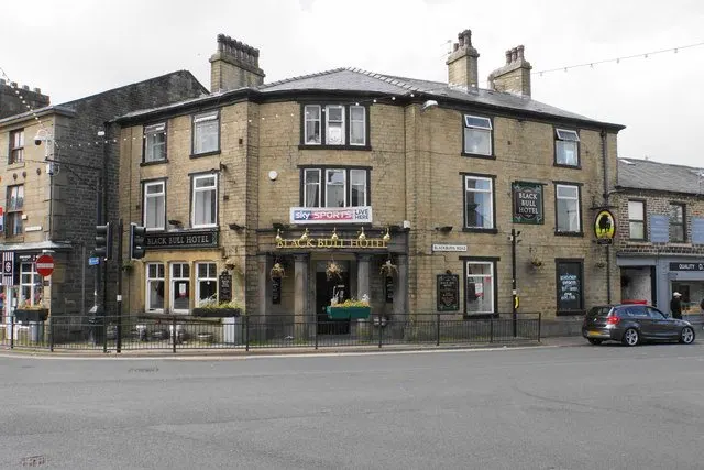
Haslingden sits in the Rossendale valley in Lancashire, a stone-built former mill town of around 16,849 people with moors on the doorstep and Rawtenstall just up the road. It is the sort of place where the centre is small enough to walk across, and where you will see the same faces in the Co-op most weeks.
For tenants thinking about a move, the appeal is straightforward. You get a proper town with its own library, shops, pubs and a good spread of schools, but you are never far from open hills. Prices for social rents across the Rossendale council area are modest by national standards, and the town is close enough to larger centres that work and bigger shopping are within reach.
This guide sets out what daily life here actually looks like: getting about by bus, car, foot or train, what families get out of the town, what there is to do, and who lives in the social homes here. It is not a sales pitch. If Haslingden suits you, it will suit you for sensible, everyday reasons.
Swapping to Haslingden: key facts
Can I swap my council or housing association home to Haslingden?
Yes, if you are already a council or housing association tenant. Mutual exchange means swapping homes with another social tenant, so it does not depend on the council waiting list: you need a tenant in or near Haslingden who wants your area, and both landlords must agree. Landlords have 42 days to decide and can only refuse on set legal grounds.
How long is the council housing waiting list in Haslingden?
1,643 households were on the Rossendale housing register on 31 March 2025, down 8% on a year earlier. Source: Local Authority Housing Statistics, Ministry of Housing, Communities and Local Government.
How much is social rent in Haslingden?
Average weekly social rents in the Rossendale council area in 2024/25: 1 bed £0 council, £83 housing association; 2 bed £0 council, £94 housing association; 3 bed £0 council, £105 housing association. Affordable rent homes cost more, typically 60 to 80% of market rent. Source: Regulator of Social Housing.
How much social housing is there in Haslingden and who owns it?
14.8% of homes in the Rossendale council area are social housing (council 3.9%, housing association 10.9%), against 17.1% across England, according to the 2021 Census. The biggest social landlords there are Together Housing Association Limited (3,669 homes), Places for People Homes Limited (189 homes) and Your Housing Limited (175 homes).
How Busy Is The Swap Market In Haslingden?
Figures as of 21 October 2026, updated every night. The waiting list figure is from 2024 to 2025 government data.
Which homes are available to swap near Haslingden?
Homes are shown near their address, not on it. Contains OS data © Crown copyright and database right. Source: Office for National Statistics, Open Government Licence.
No homes listed within 5 miles at the moment. New homes are listed every week: see homes across Lancashire, use the alert form below, or list your own home so tenants here can find you.
What is housing like in Haslingden and who lives there?
Housing here is dominated by owner-occupation. Across the Rossendale council area, 67.9% of homes are owned outright or with a mortgage, 17% are privately rented and 14.8% are social rented, below the England figure of 17.1%. Of that social stock, most is housing association rather than council: 10.9% against 3.9%.
Together Housing Association is by far the biggest landlord locally with around 3,669 homes, followed by Places for People Homes, Your Housing, Regenda and Calico Homes, each with a few hundred or fewer. If you are swapping in, there is a fair chance your new landlord will be Together.
Rents are reasonable. Average weekly social rents in the council area for 2024/25 were about £83 for a one-bed, £94 for two beds and £105 for three. The Rossendale housing register held 1,643 households at 31 March 2025, and no social homes were let through the council in 2024-25, which is a plain reminder that mutual exchange is often the realistic route in rather than waiting.
Council waiting list and lettings
Households on the register by the size of home they need.
A register counts households who have applied, so it isn't a simple queue: some are already social tenants hoping to transfer, and people can be on more than one council's list.
Typical weekly social rents in the Rossendale council area
| Size | Council | Housing association |
|---|---|---|
| Bedsit | £0 | £73 |
| 1 bed | £0 | £83 |
| 2 bed | £0 | £94 |
| 3 bed | £0 | £105 |
| 4 bed | £187 | £114 |
Social rent averages for 2024/25. Affordable rent homes cost more, typically 60 to 80% of market rent.
Biggest social landlords in the council area
- Together Housing Association Limited3,669 homes
- Places for People Homes Limited189 homes
- Your Housing Limited175 homes
- Regenda Limited175 homes
- Calico Homes Limited121 homes
- Housing 2199 homes
- Anchor Hanover Group71 homes
- The Guinness Partnership Limited68 homes
What is it like to live in Haslingden?
Daily life is small-scale and that is the charm. The centre is compact, so a loaf of bread, a prescription and a library book can be one short trip. Weather shapes the week more than you might expect: the valley catches wind and rain, and the slopes are steep in places, so think about hills if you or anyone in the house finds walking hard.
The mix of people is broad. Across the Rossendale council area, 28.3% are aged 45 to 64 and 19.3% are 65 or over, both a little above the England average, with 24.6% aged 25 to 44. In practice that means long-standing neighbours alongside younger families, and streets where people tend to know each other. If you want anonymity, this is not that sort of place. If you want to be recognised in the queue at the shop, it is.
What are the schools and family life like in Haslingden?
Families are well served for choice. Haslingden Primary School and St James' Church of England Primary School are both about 0.2 miles from the centre, with St Mary's Roman Catholic Primary School a little further at 0.4 miles and Haslingden Broadway Primary School around a mile out. For older children, Haslingden High School and Sixth Form and All Saints' Roman Catholic High School are both roughly a mile away, with Alder Grange School under two miles.
There is also specialist provision close by, including Rawtenstall Cribden House Community Special School, Tor View School and Belmont School, all within about 1.2 miles. That is unusual for a town this size and worth knowing if your child has additional needs.
Across the Rossendale council area, 19% of residents are under 16, a shade above the England figure, so this is a valley with plenty of young families in it. Green space helps: Greenfield Memorial Gardens and Pit Head Pocket Park are a couple of minutes from the centre, and Victoria Park is half a mile out.
Primary schools
- Haslingden Primary Schoolnearby
- St James' Church of England Primary Schoolnearby
- St Mary's Roman Catholic Primary School, Haslingden0.4 mi
- Haslingden Broadway Primary School1 mi
- Rawtenstall Cribden House Community Special School1 mi
Secondary schools
- All Saints' Roman Catholic High School1 mi
- Haslingden High School and Sixth Form1.1 mi
- Belmont School1.1 mi
- Tor View School1.2 mi
- Alder Grange School1.8 mi
Parks
- Greenfield Memorial Gardensnearby
- Pit Head Pocket Parknearby
- Victoria Park0.5 mi
- Worsley Park0.8 mi
- Whittaker Park West Entrance1.1 mi
Libraries
- Haslingden Librarynearby
- Rawtenstall Library1.6 mi
What shops and everyday essentials are in Haslingden?
Supermarkets
- Co-op Foodnearby
- Tesco0.8 mi
- M&S Foodhall1.3 mi
- Aldi1.4 mi
- Asda1.6 mi
Pharmacies
- Well Pharmacynearby
- Asda1.6 mi
- Boots1.6 mi
- Baxenden Pharmacy2.2 mi
How do you get around Haslingden?
Haslingden has no station of its own. The nearest are Rawtenstall, about 1.5 miles away, and Irwell Vale at around 2 miles, with Rawtenstall Bus Station roughly 1.7 miles off serving as the main interchange for the valley. If you rely on public transport, it is worth checking the specific routes and times from your street before you commit, because the valley's hills mean journeys can take longer than the map suggests.
In the town itself, a lot gets done on foot. The library, a Co-op, a pharmacy and several pubs all sit within a few hundred metres of the centre, and a Tesco is under a mile away. That matters on days when the weather is against you.
Driving opens up the valley quickly: Rawtenstall, Accrington and the wider Lancashire road network are all short hops. Parking varies street by street, and some of the older terraced rows have none off-road, so look at where you would actually leave a car.
Train stations
- Rawtenstall1.5 mi
- Irwell Vale2 mi
Bus stations
- Rawtenstall Bus Station1.7 mi
What is there to do in Haslingden?
The pub scene is central to Haslingden life. The Black Bull and Commercial Hotel sit right in the middle of town, with The Bay Horse, The Green Squirrel and the Griffin all within half a mile. You could walk between the lot of them in an afternoon, which plenty of people do.
For quieter days, Haslingden Library is barely 0.1 miles from the centre and Rawtenstall Library is 1.6 miles away. Parks give you a decent spread for walks and kickabouts: Greenfield Memorial Gardens, Pit Head Pocket Park, Victoria Park, Worsley Park and the western entrance to Whittaker Park are all within just over a mile.
Beyond that, the moorland edges of the Rossendale valley are the main draw, and they are free. If you want a gym, Riverside Health Club is about 1.3 miles off. Organised community activity is thinner on the ground in the immediate area: St Thomas' Church Hall, 1.3 miles away, is the nearest listed community centre, so a lot of social life runs through schools, churches and the pubs.
Gyms
- Riverside Health Club1.3 mi
Pubs and bars
- Black Bullnearby
- Commercial Hotelnearby
- The Bay Horsenearby
- The Green Squirrel0.3 mi
- Griffin0.4 mi
Community centres
- St Thomas' Church Hall1.3 mi
What is work and the local economy like in Haslingden?
Employment in the Rossendale council area looks steady rather than spectacular. Around 57.8% of adults are in work, just above the England figure of 57.4%, and unemployment sits at 2.7% against 3.5% nationally. Unemployment-related benefit claims were 3.9% of working-age residents in August 2026, a touch below the England rate of 4%.
In practice, a good number of people here work outside the town. The valley road network and the bus links through Rawtenstall put larger Lancashire and Greater Manchester employment areas within commuting distance, though journeys are rarely quick. If your job depends on shift times or early starts, map the route properly before you move.
Locally, the schools, shops, supermarkets and health services are among the visible employers, with a Tesco under a mile away and an Asda, Aldi and M&S Foodhall all within about 1.6 miles. For self-employed and home-based workers, the town's low-key pace and cheaper rents can work in your favour.
Figures are for the Rossendale council area, Census 2021 and ONS claimant count.
How safe is Haslingden?
Like every town centre, Haslingden has police incidents logged each month. In August 2026 there were 96 within about a mile of the centre, made up of:
- Anti-social behaviour reports21
- Vehicle crime4
- Bicycle theft1
- Shoplifting2
- Criminal damage11
- Burglary3
Source: data.police.uk street-level crime. Counts cover a fixed one-mile radius around the centre, so busy high streets and stations always record far more than the residential streets around them, and most incidents are minor. Compare like with like: a similar-sized town centre, not a village.
Is Haslingden a good place for social housing tenants?
If Haslingden sounds like the right fit, the next step is simple and free. List your own home on Mutual Home Exchange with honest photographs and a clear description of the rooms, the heating, any garden or parking, and the floor it sits on. Then set Haslingden, or BB4 more broadly, as a desired area so tenants here can find you.
It helps to be flexible. Adding Rawtenstall and the rest of the Rossendale valley widens your options considerably without moving you far from the schools, parks and shops described here. Say plainly what you need, whether that is a ground floor, a third bedroom or a garden, and what you can be relaxed about.
Matches often take time, so keep your listing current and reply to messages promptly. When something looks promising, visit at different times of day, walk the route to the bus stop or the school gate, and ask the tenant what the street is really like. Both landlords have to agree the swap, so start that conversation early.
Good luck. Taking it steadily is far better than taking the first offer that comes along.
','
Tell me when a home appears near Haslingden
One email, the first time a council or housing association home is listed within your chosen distance. No newsletter, no spam.
Live in Haslingden? Add a photo
Tenants' own photos help other people picture the place. Approved photos are credited to you. Submit a photo.
Nearby place guides
Thinking of moving a little further? Compare homes to swap, rents and local landlords in places near Haslingden.
All place guides in Lancashire → · All place guides in the North West → · All regions →