Living in Leicester city centre: a guide for home swappers
1 council and housing association home available to swap within 5 miles of Leicester.
"I'd move here" adds Leicester to the areas on your listing, so homes here are matched to you first.
This guide covers LE1, the heart of Leicester. It is the city centre proper: arcades, market streets, a big railway station and bus stands on almost every corner. Leicester is a city of about 368,571 people, and the centre is where most of it passes through.
It suits people who want everything within a short walk and do not want the cost of a car. It suits students, workers on shifts, and families who value being close to schools, libraries and shops. It is less peaceful than the suburbs, and you should go in knowing that.
Right now there is one swap listing within five miles on Mutual Home Exchange, so patience matters here.
Homes to swap near Leicester
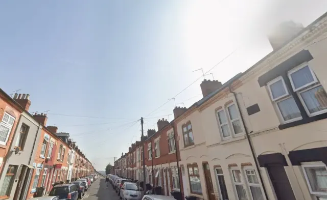
What it's like to live in Leicester
Life in LE1 is lived on foot. A Tesco Express, Fresh Village Leicester and a Poundland on Gallowtree Gate are all within a couple of minutes, with Boots, Superdrug and a Tesco pharmacy just as close. You are not planning big weekly shops so much as popping out.
Community life exists alongside the shops. Age UK's Clarence House, the Afri-Carib Culture Club, the Great Meeting Unitarian Chapel and Shree Girnara Soni Samaj UK all sit within a third of a mile, reflecting how mixed the city is.
Be honest with yourself about noise and crime. Police recorded 1,690 crimes within roughly a mile in July 2026, mostly violence, shoplifting and public order. That is typical of a busy city centre, but it is a lot of incidents in a small area.
Schools and families
There are plenty of schools close by. King Richard III Infant & Nursery is 0.6 miles away, with Sparkenhoe Primary (Saxby Building), Slater Primary, Hazel Community Primary and Taylor Road Primary all around 0.7 miles.
For older children, Castle Mead Academy is the nearest secondary at half a mile, with Brook Mead Academy and Jameah Girls Academy just over a mile. Wyggeston and Queen Elizabeth I College and St Crispin's Grammar School are both about 1.1 miles for sixth form and beyond. Check admissions directly, as city catchments can be tight.
Leicester Central Library is on your doorstep, and St Matthews Library is 0.7 miles. Leicester is a young city: 21.3% of residents are under 16, above the England figure of 18.6%.
Primary schools
- King Richard Ⅲ Infant & Nursery School0.6 mi
- Sparkenhoe Primary School - Saxby Building0.7 mi
- Slater Primary School0.7 mi
- Hazel Community Primary School0.7 mi
- Taylor Road Primary School0.7 mi
Secondary schools
- Castle Mead Academy0.5 mi
- Wyggeston and Queen Elizabeth I College1.1 mi
- St Crispin's Grammar School1.1 mi
- Brook Mead Academy1.2 mi
- Jameah Girls Academy1.2 mi
Parks
- Town Hall Squarenearby
- St George's Churchyard0.3 mi
- Castle Motte0.3 mi
- Spinnyhillpark0.3 mi
- Castle Gardens0.4 mi
Libraries
- Leicester Central Librarynearby
- The Greenhouse, De Montfort University DMU0.3 mi
- Eric Wood Learning Space, De Montfort University DMU0.4 mi
- Kimberlin Library0.4 mi
- St Matthews Library0.7 mi
Everyday essentials
Supermarkets
- Fresh Village Leicesternearby
- Tesco Expressnearby
- Poundland - Gallowtree Gatenearby
- Tesco Expressnearby
- The Uni Store 润嘉超市nearby
Pharmacies
- Boots Pharmacynearby
- Australia peptide zonenearby
- Superdrugnearby
- Boots Pharmacynearby
- Tesco Pharmacy0.5 mi
Hospitals
- Peptides certifiednearby
- Superdrug Aesthetics Clinic- Leicesternearby
- Glen field0.3 mi
- Jarvis Building.0.4 mi
- FlyingMedicine (Medicals and Vaccination Clinic)0.4 mi
Shopping centres
- Odeon Arcadenearby
- St Martin's Squarenearby
- Malcolm Arcadenearby
- Silver Arcadenearby
- Royal Arcadenearby
Getting around
This is one of the easiest places in the East Midlands to live without a car. Leicester railway station is 0.4 miles away, about a ten-minute walk, and Leicester North is 2.4 miles out.
Bus stands are scattered through the centre: Pocklingtons Walk, Welford Place, Rutland Street and two on Charles Street are all within a couple of hundred metres. If you work shifts or do the school run across the city, you will rarely be far from a service.
The flip side is parking. A city centre postcode usually means parking is tight and paid for, so check what comes with any property before you commit to a swap.
Train stations
- Leicester0.4 mi
- Leicester North2.4 mi
Bus stations
- Pocklingtons Walk (Stand EQ)nearby
- Welford Place (Stand EN)nearby
- Rutland Street (Stand EK)nearby
- Charles Street (Stand CH)nearby
- Charles Street (Stand CJ)nearby
Things to do
Green space is small-scale rather than sprawling. Town Hall Square is a minute away, with St George's Churchyard, Castle Motte, Spinnyhillpark and Castle Gardens all within half a mile. Good for a breather, less good for a long dog walk, so factor that in if you have a garden now.
For rainy days, Showcase Cinema de Lux and the Phoenix Cinema and Art Centre are both under half a mile, and ODEON Luxe is 0.9 miles. The arcades — St Martin's Square, Silver Arcade, Malcolm Arcade, Royal Arcade and Odeon Arcade — are all clustered together.
Gyms are everywhere, from ZFit and Everlast to smaller studios. Pubs and bars, including the Knight & Garter and Katie O'Brien's, are plentiful and lively at night.
Gyms
- ZFitnearby
- Everlast Gymsnearby
- Survival Fitness Ltdnearby
- Studio Figura Leicesternearby
- BFT Leicesternearby
Cinemas
- Sultan's Events Solution Ltd0.3 mi
- Showcase Cinema de Lux0.3 mi
- Phoenix Cinema and Art Centre0.4 mi
- ODEON Luxe Leicester0.9 mi
- JMW Sparks Electrical Ltd1.2 mi
Pubs and bars
- Knight & Garternearby
- The Friary Leicesternearby
- Inside No 9nearby
- Katie O'Brien's Irish Tavern Leicesternearby
- Market Tavernnearby
Nightlife
- Club Tanzanitenearby
- Mamba cafe by DSMnearby
- Harvey'snearby
- Fat Cat Cocktail Bar & Loungenearby
- TRUTH Leicesternearby
Community centres
- Afri-Carib Culture Clubnearby
- Age UK Leicester Shire & Rutland | Clarence House0.3 mi
- Seasons Cafe0.3 mi
- Great Meeting Unitarian Chapel0.3 mi
- Shree Girnara Soni Samaj UK0.3 mi
Work and the local economy
The city centre is a working hub: retail, hospitality, transport and the two university campuses nearby all draw staff in, and the arcades and bars mean evening and weekend hours are common.
The wider picture is tougher than the England average. Across Leicester, 53.2% of adults are in work compared with 57.4% for England, and unemployment sits at 5%, against 3.5% nationally. In August 2026, 5.4% of 16 to 64 year olds were claiming unemployment-related benefits, above the England figure of 4%.
The upside is that living centrally cuts commuting costs sharply. With the train station and bus stands walkable, jobs across the city and beyond are reachable without running a car.
Figures are for the Leicester council area, Census 2021 and ONS claimant count.
Housing and who lives here
Leicester has more social housing than England as a whole: 23.2% of homes are socially rented, split between 14.7% council and 8.4% housing association, against 17.1% nationally. Just under half of homes, 46.7%, are owned, and a large 29.4% are privately rented, which is very visible in the centre.
The population skews young. Nearly 45% of residents are aged 16 to 44, and only 11.8% are 65 or over, well below the England figure of 18.4%. That gives the centre its busy, student-heavy feel.
Expect flats and smaller terraced homes rather than large family houses with gardens. Space is the main trade-off for being this central.
Safety
Police recorded 1,690 incidents within about a mile of the centre of Leicester in July 2026. The most common were:
- Violent crime509
- Shoplifting233
- Public order223
- Anti social behaviour204
- Criminal damage arson109
Source: data.police.uk street-level crime. Counts cover a fixed one-mile radius, so busy town centres always record more than quiet suburbs.
Swapping to Leicester
Swap options in central Leicester are thin at the moment. There is one listing within five miles: a two-bed house 0.9 miles away whose tenant wants to upsize. If you have a three-bed and fancy going smaller and more central, that could be a straight match.
Because the list is short, the best thing you can do is get your own home listed and set Leicester as a desired area. New listings appear all the time, and tenants searching for a move here will find you first if you are already on the site.
It is free to list. Add clear photos, be honest about the property, and check back regularly rather than waiting for one perfect match.
Tell me when a home appears near Leicester
One email, the first time a council or housing association home is listed within your chosen distance. No newsletter, no spam.
Live in Leicester? Add a photo
Tenants' own photos help other people picture the place. Approved photos are credited to you. Submit a photo.