What it's like to live in Minster
Minster is a seaside town of around 17,400 people on the Isle of Sheppey in Kent, part of the Swale district. It feels like a sprawling, settled coastal community rather than a holiday resort: low-rise streets, plenty of older residents, young families and the sea never far away. Barton's Point Coastal Park and The Glen are both close by.
"I'd move here" adds Minster to the areas on your listing, so homes here are matched to you first.
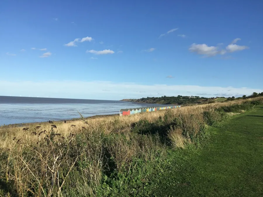
Minster sits on the Isle of Sheppey, off the north Kent coast, in the borough of Swale. Sheerness is its nearest neighbour, about two and a half miles away, with Queenborough just beyond. The mainland towns of Sittingbourne and the Medway towns lie south and west across the Swale.
People move here for a few clear reasons. Housing tends to be more affordable than much of the South East, the coast is genuinely on the doorstep, and the town has its own hospital, library and schools rather than relying entirely on somewhere else. For tenants coming from busier parts of Kent or from London, the pace is slower and the skies are bigger.
It is worth being realistic too. Minster is on an island, and that shapes everything from the commute to how often you nip out for something you forgot. Some people find that peaceful and friendly; others find it limiting. If you like the idea of a coastal town where you get to know faces, and you are happy to plan journeys off the island, it is worth a serious look.
Swapping to Minster: key facts
Can I swap my council or housing association home to Minster?
Yes, if you are already a council or housing association tenant. Mutual exchange means swapping homes with another social tenant, so it does not depend on the council waiting list: you need a tenant in or near Minster who wants your area, and both landlords must agree. Landlords have 42 days to decide and can only refuse on set legal grounds.
How long is the council housing waiting list in Minster?
1,816 households were on the Swale housing register on 31 March 2025, up 5% on a year earlier. 388 social homes were let through the council in 2024 to 2025, roughly 4.7 households for every home let. Source: Local Authority Housing Statistics, Ministry of Housing, Communities and Local Government.
How much is social rent in Minster?
Average weekly social rents in the Swale council area in 2025/26: 1 bed £0 council, £105 housing association; 2 bed £0 council, £122 housing association; 3 bed £0 council, £135 housing association. Affordable rent homes cost more, typically 60 to 80% of market rent. Source: Regulator of Social Housing.
How much social housing is there in Minster and who owns it?
13.3% of homes in the Swale council area are social housing (council 2.2%, housing association 11.1%), against 17.1% across England, according to the 2021 Census. The biggest social landlords there are Southern Housing (6,724 homes), Moat Homes Limited (1,097 homes) and Hyde Housing Association Limited (621 homes).
How much is Council Tax in Minster?
In 2026 to 2027, Council Tax in the Swale council area is £1,604 a year for Band A, £1,871 for Band B, £2,138 for Band C and £2,406 for Band D, for two adults, including police, fire and the average parish charge. The England average for Band D is £2,392. Someone living alone gets 25% off. Source: Ministry of Housing, Communities and Local Government.
What is the average salary in Minster?
The typical (median) full-time salary for people living in the Swale council area was £38,432 a year before tax in 2025, against £39,243 across England. For jobs based in the area, including people who travel in, it was £34,776. Source: Office for National Statistics, Annual Survey of Hours and Earnings.
Who is the MP for Minster?
Kevin McKenna (Labour) is the MP for Sittingbourne and Sheppey, the constituency that covers Minster. Correct on 12 November 2026. Source: UK Parliament.
How Busy Is The Swap Market In Minster?
Figures as of 12 November 2026, updated every night. The waiting list figure is from 2024 to 2025 government data.
Homes to swap near Minster
Homes are shown near their address, not on it. Contains OS data © Crown copyright and database right. Source: Office for National Statistics, Open Government Licence.
No homes listed within 5 miles at the moment. New homes are listed every week: see homes across Kent, use the alert form below, or list your own home so tenants here can find you.
Housing in Minster
Housing figures here are for the Swale council area. Social renting accounts for 13.3% of homes, below the England average of 17.1%, split between housing associations at 11.1% and the council at just 2.2%. Owner occupation is high at 67%, with 18.4% privately rented. So social homes are a smaller slice of the market than in many places, which is one reason mutual exchange is worth pursuing.
Average weekly social rents in Swale for 2025/26 are about £105 for a one bed, £122 for two beds and £135 for three. The largest social landlord by far is Southern Housing with 6,724 homes, followed by Moat Homes, Hyde Housing Association, The Riverside Group and West Kent Housing Association.
The age profile across Swale is close to the national picture, with slightly more people aged 45 to 64 and 65 and over. For context on demand, the council's housing register held 1,816 households at the end of March 2025 and 388 social homes were let through the council in 2024-25; a register is not a simple queue.
Who owns the homes
Share of homes in the Swale council area, Census 2021.
Ages
Share of people in each age group, Census 2021.
Council waiting list and lettings
Households on the register by the size of home they need.
That is roughly 4.7 households waiting for every social home let in a year. Mutual exchange doesn't use the waiting list: if you already have a council or housing association home, swapping with another tenant can be a quicker way to move to Minster.
A register counts households who have applied, so it isn't a simple queue: some are already social tenants hoping to transfer, and people can be on more than one council's list.
Typical weekly social rents in the Swale council area
Social rent averages for 2025/26. Affordable rent homes cost more, typically 60 to 80% of market rent.
Biggest social landlords in the council area
- Southern Housing6,724 homes
- Moat Homes Limited1,097 homes
- Hyde Housing Association Limited621 homes
- The Riverside Group Limited291 homes
- West Kent Housing Association254 homes
- Sanctuary Affordable Housing Limited144 homes
- Places for People Homes Limited129 homes
- Golding Homes Limited124 homes
Compare these landlords against every other on tenant satisfaction, repairs and complaints.
Living in Minster
Day to day, life here is fairly self-contained. There's a Co-op about three quarters of a mile away for the weekly shop, Minster Pharmacy nearby, and a library on your doorstep at Minster-in-Sheppey. Sheppey Community Hospital is under a mile away, which matters more than people realise until they need it.
The town is well served for places to gather. Friendship House and New Road Community Centre are both a short walk, with Thistle Hill Community Centre a little further out. Pubs and bars sit right in the middle of things, including The Highlander and Charisma Cocktail Bar, with The Harps Inn and The Beach a short stroll away. For bigger shops, Sheerness is a couple of miles west with Aldi, Morrisons and Tesco.
Schools in Minster
Families are well covered for schools. Minster in Sheppey Primary School is just 0.1 miles away, with St. George's Church of England Primary School at 0.4 miles and Thistle Hill Academy at 0.7 miles. Halfway Houses Primary and Richmond Primary are both under two miles for anyone looking a little wider.
For older children, Elmley Dray School is 0.7 miles away, Oasis Academy Isle of Sheppey East Campus is 1.2 miles and EKC Sheppey Secondary is 1.9 miles. Having three secondaries inside two miles is unusual for a town this size and means teenagers can often travel independently.
Outside school, The Glen is a short walk and Barton's Point Coastal Park, 1.4 miles away, is the bigger day-out option by the water. Minster-in-Sheppey Library is 0.3 miles away for rainy afternoons and reading schemes. Friendship House, New Road Community Centre and Thistle Hill Community Centre host local groups, and St Peter's Church Hall and Eastchurch Village Hall are within a few miles. Always check current places and catchments with the council before you swap.
Primary schools
- Minster in Sheppey Primary School Report card 2026nearby
- St. George's Church of England Primary School Good 20240.4 mi
- Thistle Hill Academy Inspected 20240.7 mi
- Halfway Houses Primary School Good 20241.4 mi
- Richmond Primary School Good 20221.8 mi
Secondary schools
- Elmley Dray School0.7 mi
- Oasis Academy Isle of Sheppy - East Campus1.2 mi
- EKC Sheppey Secondary1.9 mi
Parks
- The Glen0.4 mi
- Barton's Point Coastal Park1.4 mi
- Vincent Gardens2.2 mi
Libraries
- Minster-in-Sheppey Library0.3 mi
- Sheerness Library2.5 mi
- Queenborough Library2.8 mi
Green good or better (on report cards, the expected standard or better), amber requires improvement or an area needs attention, red inadequate or an area needs urgent improvement, with the year of the inspection. Since September 2024 Ofsted no longer gives one overall grade, so newer results ("Report card", "Inspected") are coloured by their weakest area. Click a school for its full report. Ofsted data at 31 October 2026.
Shops in Minster
Supermarkets
- Co-op Food0.8 mi
- Aldi2.3 mi
- Morrisons2.4 mi
- Tesco2.6 mi
Pharmacies
- Minster Pharmacy0.6 mi
- Delmergate Pharmacy2.3 mi
- Superdrug2.4 mi
- Mistry Chemist2.5 mi
- Well Pharmacy2.8 mi
Hospitals
- Sheppey Community Hospital0.9 mi
Getting around Minster
Minster has no station of its own. The nearest are Sheerness-on-Sea, about 2.6 miles away, and Queenborough at 2.7 miles, both on the branch line that runs down the island and across to the mainland. If you commute by train, factor in getting to the station first, by bus, bike, car or a long walk.
Within Minster itself, plenty is walkable. The primary school, library, community centres and several pubs are all within half a mile of the centre, and the pharmacy and hospital are under a mile. Pavements are generally flat, which helps with buggies and shopping trolleys.
By car, the island is linked to the mainland by the crossing over the Swale, with Sittingbourne and the M2 corridor beyond. Driving makes the bigger supermarkets, the Jobcentre in Sheerness and the gym at Snap Fitness easy. Without a car, you will lean on buses for trips across the island, so it is worth checking current routes and times from the exact street you are considering before you commit to a swap.
Train stations
- Sheerness-on-Sea2.6 mi
- Queenborough2.7 mi
Things to do in Minster
The coast is the main draw. Barton's Point Coastal Park, just over a mile away, is the big open space for walking, pushchairs and letting children run about, while The Glen at 0.4 miles is the handy everyday green space. Vincent Gardens, a little over two miles away, gives another option.
For evenings out, Minster has more choice than you might expect for its size. Charisma Cocktail Bar, The Highlander and Banks Restaurant are right in the centre, with The Harps Inn and The Beach within a short walk. It is a local scene rather than a night-life destination, which suits plenty of people fine.
Beyond that, the library at 0.3 miles is a genuine community hub, and Sheerness Library and Queenborough Library are within three miles if you want a change. Snap Fitness, about 2.5 miles away, is the nearest gym listed, so regular gym-goers should plan how they will get there. Community centres run much of what else happens locally, so it is worth asking neighbours what is on.
Gyms
- Snap Fitness2.5 mi
Pubs and bars
- Charisma Cocktail Barnearby
- The Highlandernearby
- Banks Restaurantnearby
- The Harps Inn0.5 mi
- The Beach0.6 mi
Community centres
- Friendship Housenearby
- New Road Community Centrenearby
- Thistle Hill Community Centre0.8 mi
- St Peter's Church Hall1.8 mi
- Eastchurch Village Hall2.2 mi
Jobs in Minster
Employment figures here cover the wider Swale council area rather than Minster alone. Around 56.7% of adults are in work, just below the England figure of 57.4%, and unemployment sits at 3.2% against 3.5% for England. More recent figures put unemployment-related benefit claimants at 3.5% of working-age people in August 2026, below the England rate of 4%.
In short, the local jobs picture is broadly in line with the national one, without being especially strong or weak. Many people on the Isle of Sheppey travel off the island for work, towards Sittingbourne, the Medway towns and beyond, so a reliable route matters if you are job-hunting.
Practical help is close: Jobcentre Plus is about 2.6 miles away in Sheerness. If you are moving for work, check the commute carefully at peak times, because the island crossing and the branch line both shape how long journeys take. For anyone working from home, a short walk to the shops, hospital and library makes the day easier.
Figures are for the Swale council area, Census 2021 and ONS claimant count.
Typical Pay
Median yearly pay before tax for full-time workers, 2025. Half earn more than this and half earn less.
Where The Jobs Are
The five biggest industries by share of employee jobs, 2024. "Health" includes hospitals, GP surgeries and care homes.
Jobcentres And Recruitment Agencies
- Jobcentre Plus2.6 mi
From OpenStreetMap, which doesn't list every agency. Find more on Find a job (GOV.UK).
Council tax and MP in Minster
Council Tax 2026 to 2027
Yearly bill for two adults, including police, fire and the average parish charge. Most council and housing association homes are in Bands A to C. Living alone takes 25% off, and you may get Council Tax Reduction on a low income.
Your MP
Kevin McKenna (Labour) is the MP for Sittingbourne and Sheppey, which covers Minster. Near the edges, find the MP for your postcode.
An MP can help with problems involving government departments and, sometimes, your landlord or council.
Broadband in Minster
Share of homes that can get each speed, Ofcom, January 2026. Check an address on Ofcom's broadband checker.
Deprivation in Minster
The Swale council area ranks 62nd of 296 council areas in England on the Index of Multiple Deprivation 2025, where 1st is the most deprived. 14.4% of its neighbourhoods are among the most deprived 10% in England.
The index combines seven measures, including income, work, health, education and housing. It describes areas, not the people who live in them.
Is Minster safe?
Like every town centre, Minster has police incidents logged each month. In September 2026 there were 87 within about a mile of the centre, made up of:
Source: data.police.uk street-level crime. Counts cover a fixed one-mile radius around the centre, so busy high streets and stations always record far more than the residential streets around them, and most incidents are minor. Compare like with like: a similar-sized town centre, not a village.
Swapping to Minster
If Minster looks like the right fit, the next step is simple: put your own home on Mutual Home Exchange and set Minster, or the wider ME12 area, as a place you want to move to. Swaps happen when the right two or three households find each other, and you cannot be found if you are not listed.
Write your advert the way you would want to read one. Say how many bedrooms you have, which floor you are on, whether there is a garden or parking, and what your landlord and rent are. Add clear photos, including the outside. Be honest about anything that needs work: it saves time and builds trust.
Then be patient and keep looking. Check new listings regularly, message people whose homes suit you rather than waiting to be contacted, and consider a three-way swap if a direct match is not appearing. Visit Minster first if you can, at different times of day, and walk the route from the home to the school, shop or station you would use. Both landlords must approve any exchange before you move.
Home alerts for Minster
One email, the first time a council or housing association home is listed within your chosen distance. No newsletter, no spam.
Nearby place guides
Thinking of moving a little further? Compare homes to swap, rents and local landlords in places near Minster.
All place guides in Kent → · All place guides in the South East → · All regions →