What it's like to live in Radlett
What is it like to live in Radlett? It is a small, well-kept commuter town in Hertfordshire with a village feel, suiting families and anyone who wants quiet streets and green space without cutting themselves off from London. Life centres on one main shopping street, and there is open countryside close by, plus Watling Street Garden barely a minute from the shops.
"I'd move here" adds Radlett to the areas on your listing, so homes here are matched to you first.
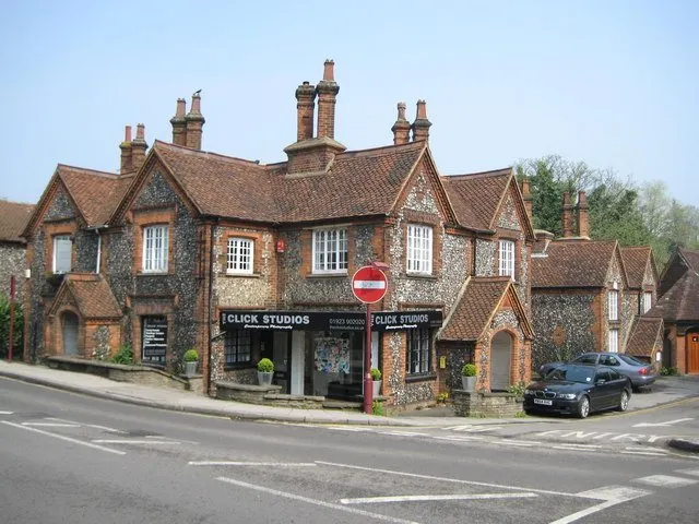
Radlett is a small Hertfordshire town of around 10,060 people, sitting in the Hertsmere district between St Albans and Borehamwood. It is neat, green and leafy, built around one long main street of shops rather than a big centre. Everything you need day to day is close together, which is one of its real strengths.
The town is best known for its railway station, a short walk from the high street, and for the countryside that wraps around it. Watling Street Garden is on the doorstep, and Phillimore Recreation Ground is a few minutes away. Battlers Green Farm, just under a mile out, adds a cluster of shops away from the main parade.
For a council or housing association tenant thinking of moving here, the honest picture is this: Radlett is a comfortable, quiet, mostly owner-occupied town where social housing is a small slice of the whole. That makes a swap here harder to line up, but it also makes it worth being patient for. This guide sets out what living here is actually like.
Swapping to Radlett: key facts
Can I swap my council or housing association home to Radlett?
Yes, if you are already a council or housing association tenant. Mutual exchange means swapping homes with another social tenant, so it does not depend on the council waiting list: you need a tenant in or near Radlett who wants your area, and both landlords must agree. Landlords have 42 days to decide and can only refuse on set legal grounds.
How long is the council housing waiting list in Radlett?
717 households were on the Hertsmere housing register on 31 March 2025, up 7% on a year earlier. 259 social homes were let through the council in 2024 to 2025, roughly 2.8 households for every home let. Source: Local Authority Housing Statistics, Ministry of Housing, Communities and Local Government.
How much is social rent in Radlett?
Average weekly social rents in the Hertsmere council area in 2025/26: 1 bed £0 council, £127 housing association; 2 bed £0 council, £150 housing association; 3 bed £0 council, £172 housing association. Affordable rent homes cost more, typically 60 to 80% of market rent. Source: Regulator of Social Housing.
How much social housing is there in Radlett and who owns it?
17.3% of homes in the Hertsmere council area are social housing (council 2%, housing association 15.3%), against 17.1% across England, according to the 2021 Census. The biggest social landlords there are Clarion Housing Association Limited (4,560 homes), Peabody Trust (1,644 homes) and Hightown Housing Association Limited (288 homes).
How much is Council Tax in Radlett?
In 2026 to 2027, Council Tax in the Hertsmere council area is £1,604 a year for Band A, £1,871 for Band B, £2,139 for Band C and £2,406 for Band D, for two adults, including police, fire and the average parish charge. The England average for Band D is £2,392. Someone living alone gets 25% off. Source: Ministry of Housing, Communities and Local Government.
What is the average salary in Radlett?
The typical (median) full-time salary for people living in the Hertsmere council area was £43,813 a year before tax in 2025, against £39,243 across England. For jobs based in the area, including people who travel in, it was £45,103. Source: Office for National Statistics, Annual Survey of Hours and Earnings.
Who is the MP for Radlett?
Radlett is split between more than one constituency. Sir Oliver Dowden (Conservative) is the MP for Hertsmere, which covers the centre; the area also includes St Albans. Correct on 11 November 2026. Source: UK Parliament.
How Busy Is The Swap Market In Radlett?
Figures as of 15 November 2026, updated every night. The waiting list figure is from 2024 to 2025 government data.
Homes to swap near Radlett
Homes are shown near their address, not on it. Contains OS data © Crown copyright and database right. Source: Office for National Statistics, Open Government Licence.
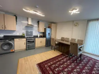 2-bed flat in Hendon £1,340 p/m Wants to move to Colindale
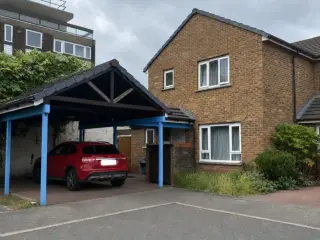 3-bed house in London £950 p/m Wants to move to W11 or Notting Hill +1 more
No homes listed within 5 miles at the moment. New homes are listed every week: see homes across Hertfordshire, use the alert form below, or list your own home so tenants here can find you.
Housing in Radlett
Radlett is mostly owner-occupied, and the Hertsmere figures reflect that: 64.2% of homes are owned, 17.3% privately rented and 17.3% socially rented. That social share is close to the England figure of 17.1%, but it is spread across the whole district, and in a town like Radlett social homes are thinner on the ground than in Borehamwood.
The biggest social landlords across Hertsmere are Clarion Housing Association with 4,569 homes and Peabody Trust with 1,652, followed by Hightown, Notting Hill Genesis and Watford Community Housing Trust. Average weekly social rents in 2024/25 were £124 for a one bed, £146 for two beds and £167 for three.
The council's housing register held 717 households at 31 March 2025, with 259 social homes let through the council in 2024-25. A register is not a simple queue, which is one reason mutual exchange is worth exploring. Hertsmere's age profile is broadly typical of England, with slightly more 45 to 64 year olds.
Who owns the homes
Share of homes in the Hertsmere council area, Census 2021.
Ages
Share of people in each age group, Census 2021.
Council waiting list and lettings
Households on the register by the size of home they need.
That is roughly 2.8 households waiting for every social home let in a year. Mutual exchange doesn't use the waiting list: if you already have a council or housing association home, swapping with another tenant can be a quicker way to move to Radlett.
A register counts households who have applied, so it isn't a simple queue: some are already social tenants hoping to transfer, and people can be on more than one council's list.
Typical weekly social rents in the Hertsmere council area
Social rent averages for 2025/26. Affordable rent homes cost more, typically 60 to 80% of market rent.
Biggest social landlords in the council area
- Clarion Housing Association Limited4,560 homes
- Peabody Trust1,644 homes
- Hightown Housing Association Limited288 homes
- Notting Hill Genesis285 homes
- Watford Community Housing Trust171 homes
- Paradigm Homes Charitable Housing Association Limited140 homes
- Sanctuary Housing Association129 homes
- Pine Ridge Housing Association Limited118 homes
Compare these landlords against every other on tenant satisfaction, repairs and complaints.
Living in Radlett
Day to day, things are within easy reach. Tesco Express and Budgens sit on the high street, with Manor Pharmacy and Boots alongside them, and Radlett Library is a couple of minutes away. It means a lot of errands can be done on foot, though a car is still handy for bigger shops at Colney Fields Shopping Park.
It is not a lively night-time town. The Red Lion and No.58 Watling Street are right in the centre, and there are places to eat, but for a cinema you head to Borehamwood. If you like calm evenings and being able to walk home from the station, that trade-off will suit you well.
Schools in Radlett
Radlett is a family town, and it shows in the number of schools close by. St Johns Infants School is 0.4 miles away, Newberries Primary School 0.5 miles, and Fair Field Junior School 0.8 miles. Radlett Preparatory School and Hertsmere Jewish Primary School are both a little over a mile out. Across the wider Hertsmere area, under-16s make up 19.9% of the population, a touch above the England figure of 18.6%.
For secondary, Hertswood Academy is 2.6 miles away and Queens' School 2.8 miles, with Haberdashers' Girls' School at 2.1 miles and Elstree Screen Arts Academy at 2.9 miles. The National Autistic Society's Radlett Lodge School is 1.4 miles from the centre. Always check current catchment and admission rules with the council before you commit to a swap.
For time out of the house there is Phillimore Recreation Ground, Picnic Field under a mile away, and Radlett Library for rainy days. Battlers Green Farm makes an easy weekend outing.
Primary schools
- St John's Church of England Infant and Nursery School Good 20220.4 mi
- Newberries Primary School Good 20220.5 mi
- Fair Field Junior School Good 20230.8 mi
- Hertsmere Jewish Primary School Good 20241.1 mi
- Radlett Preparatory School1.1 mi
Secondary schools
- Edge Grove School1.3 mi
- Aldenham School1.4 mi
- Radlett Lodge School1.4 mi
- Haberdashers' Boys' School2 mi
- Haberdashers' Girls' School2.1 mi
Parks
- Grace Avenue Public Open space1.2 mi
- Shenley Park1.6 mi
- Brook Meadow1.7 mi
- Thirskcliffe Nature Park2.1 mi
- Aberford Park2.2 mi
Libraries
- Borehamwood Library2.7 mi
- London Colney Community Library2.8 mi
Green good or better (on report cards, the expected standard or better), amber requires improvement or an area needs attention, red inadequate or an area needs urgent improvement, with the year of the inspection. Since September 2024 Ofsted no longer gives one overall grade, so newer results ("Report card", "Inspected") are coloured by their weakest area. Click a school for its full report. Ofsted data at 31 October 2026.
Shops in Radlett
Supermarkets
- Budgensnearby
- Tesco Express1.6 mi
- Co-op Food1.9 mi
- Costcutter2.4 mi
- Lidl2.5 mi
Pharmacies
- Manor Pharmacynearby
- Bootsnearby
- Wellswood Pharmacy2.6 mi
- Bricket Wood Pharmacy2.7 mi
- Care Chemist2.7 mi
Hospitals
- Kingsley Green Hospital1.4 mi
Getting around Radlett
Radlett station is the big draw. It is around 0.1 miles from the centre of town, so for most people it is a short walk rather than a drive, and it puts St Albans, Luton and central London on the line. Bricket Wood and How Wood are both within about two and a half miles if you want alternatives, and Elstree & Borehamwood is 2.7 miles away.
Buses are more of a mixed bag. The nearest larger bus stops are at Colney Fields Retail Park and around Elstree & Borehamwood station, both roughly 2.6 to 2.7 miles out, so bus travel tends to suit journeys between towns more than short local hops.
By car you are close to the main north-south routes through Hertsmere, with Borehamwood, St Albans and Watford all a short drive. Parking on and around the high street can be busy at peak times. On foot, the town is flat and compact, and the shops, library and park are all clustered together.
Train stations
- Radlettnearby
- Bricket Wood2.3 mi
- How Wood2.6 mi
- Elstree & Borehamwood2.7 mi
- Garston2.8 mi
Things to do in Radlett
Most of what Radlett offers is low-key and local. The high street has pubs and restaurants, including the Red Lion and No.58 Watling Street, with The Three Horseshoes about a mile and a half out. Radlett Library is 0.2 miles from the centre and doubles as a useful community spot.
Green space is the everyday pleasure here. Watling Street Garden is right in the middle of town, Phillimore Recreation Ground is a short walk, and Picnic Field is under a mile away. Battlers Green Farm, just under a mile out, is a shopping and browsing destination in its own right.
For fitness there is a decent spread of small independent gyms and clubs within a mile, including Hayes Fitness, Thrive Athletic and Brave. Community life includes Radlett Reform Synagogue and Bayit Chabad Lubavitch, both in the town centre. If you want a cinema, Reel Cinema Borehamwood is 2.7 miles away, and Colney Fields Shopping Park is a similar distance for a bigger shopping trip.
Gyms
- Anytime Fitness2.5 mi
- PureGym2.7 mi
Cinemas
- Reel Cinema2.7 mi
Pubs and bars
- Red Lion Hotelnearby
- No 58 Watling Streetnearby
- The Round Bush1.4 mi
- The Three Horseshoes1.4 mi
- The Oak1.6 mi
Community centres
- Christ Church Vision Hall0.3 mi
- Shenley Village Family Centre1.7 mi
- Shenley Village Hall1.7 mi
- Shenley Parish Council "The Hub"1.7 mi
- Allum Lane Community Centre2.6 mi
Jobs in Radlett
The wider Hertsmere area does well on work. Around 61.2% of adults are in employment, above the England figure of 57.4%, and unemployment sits at 3.2% against 3.5% nationally. Benefit claims linked to unemployment were 3.6% of working-age people in August 2026, below the England figure of 4%.
Radlett itself is a small town, so local jobs are mostly in shops, schools, care, hospitality and the services that keep the place running. Battlers Green Farm and the high street provide some of that, and there are health facilities including Kingfisher Court and the Forest House and Kingsley Green sites around 1.3 miles away.
Many people here commute. The station makes London, St Albans and Luton realistic for daily travel, and Borehamwood and Watford are a short drive or train ride. If your work is London-based or shift-based, check the timetable carefully for early and late services before you decide, as that will shape your day more than anything else.
Figures are for the Hertsmere council area, Census 2021 and ONS claimant count.
Typical Pay
Median yearly pay before tax for full-time workers, 2025. Half earn more than this and half earn less.
Where The Jobs Are
The five biggest industries by share of employee jobs, 2024. "Health" includes hospitals, GP surgeries and care homes.
Jobcentres And Recruitment Agencies
- Jobcentre Plus2.8 mi
From OpenStreetMap, which doesn't list every agency. Find more on Find a job (GOV.UK).
Council tax & MP in Radlett
Council Tax 2026 to 2027
Yearly bill for two adults, including police, fire and the average parish charge. Most council and housing association homes are in Bands A to C. Living alone takes 25% off, and you may get Council Tax Reduction on a low income.
Your MP
Radlett has more than one MP. Sir Oliver Dowden (Conservative) is the MP for Hertsmere, which covers the centre; the area also includes St Albans. Find the MP for your postcode.
An MP can help with problems involving government departments and, sometimes, your landlord or council.
Broadband in Radlett
Share of homes that can get each speed, Ofcom, January 2026. Check an address on Ofcom's broadband checker.
Deprivation in Radlett
The Hertsmere council area ranks 214th of 296 council areas in England on the Index of Multiple Deprivation 2025, where 1st is the most deprived. 1.6% of its neighbourhoods are among the most deprived 10% in England.
The index combines seven measures, including income, work, health, education and housing. It describes areas, not the people who live in them.
Is Radlett safe?
Like every town centre, Radlett has police incidents logged each month. In July 2026 there were 38 within about a mile of the centre, made up of:
Source: data.police.uk street-level crime. Counts cover a fixed one-mile radius around the centre, so busy high streets and stations always record far more than the residential streets around them, and most incidents are minor. Compare like with like: a similar-sized town centre, not a village.
Swapping to Radlett
If Radlett appeals, the practical step is to list your own home on Mutual Home Exchange and set Radlett, or the WD7 postcode district, as a desired area. Swaps here are unlikely to fall in your lap given how little social housing the town holds, so being visible and ready matters.
Write your advert with care. Describe your home honestly, say what is good about your current area, and add clear photos. Many tenants in a small town like this are weighing up a move for family reasons or to be nearer work, so explain plainly why you want to come here and what you can offer in return. Be open to a three-way swap, which often unlocks moves that a straight two-way cannot.
Before anything is agreed, check the details: your landlord's permission, the tenancy type you would be taking on, rent levels and the condition of the property. Visit at different times of day and walk from the home to the station and the shops. Take your time, and only say yes when it genuinely fits.
Home alerts for Radlett
One email, the first time a council or housing association home is listed within your chosen distance. No newsletter, no spam.
Nearby place guides
Thinking of moving a little further? Compare homes to swap, rents and local landlords in places near Radlett.
All place guides in Hertfordshire → · All place guides in the East of England → · All regions →